
SNOW SEASON OUTLOOK 2012 Australia UPDATE
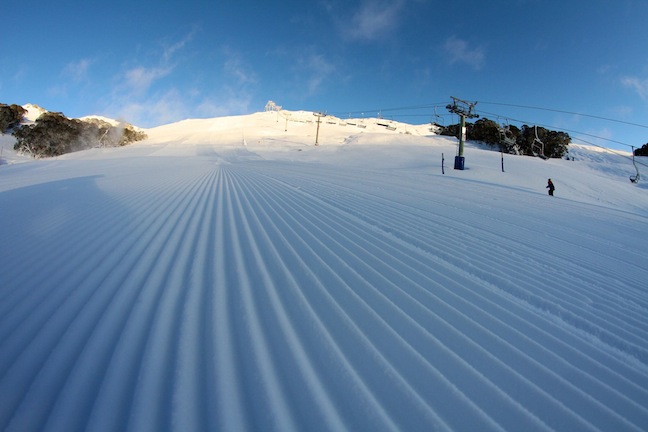
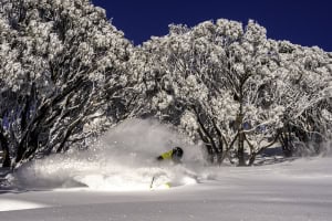
Early season perfection at Falls Creek on 13 July 2011. Image:: Falls Creek
Season Outlooks | The Grasshopper
The Grasshopper is excited. Not only do our daily forecast updates start today, but it’s also time for an update to our 2012 Season Outlook and I have some positive news to share.
You can read the April edition of my snow outlook here. The long and the short of it was that I was picking a peak snow depth of 170cm at Spencer’s Creek in the Snowy Mountains, just shy of their long term median of 176cm. I was also expecting a fairly slow start to the year, and was a bit worried some warmer temperatures and high humidity could bite snow-making where it hurts
So what’s new? Well we’re still looking at a neutral winter in terms of El Nino and the Indian Ocean Dipole. Some indicators are starting to hint at an El Nino by spring.
But what has got me very interested is a signal for some lower than average surface pressures to the south of Tasmania in a few of the main global climate models. If these models are right, then we can expect more frequent or deeper lows stomping from west to east through the oceans south of Tassie, and this means we can also expect slightly stronger or more frequent westerlies over the resorts, accompanied by some decent frontal action.
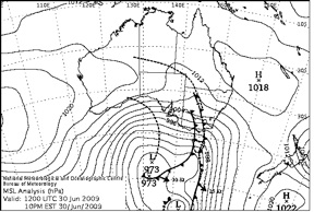
In seasonal outlooks from years past I’ve talked about how positive a persistent westerly flow can be for snow in the Aussie Alps. One of my favourite examples is from June 2009, when a good westerly flow dumped about 50cm on Thredbo. You will notice that in the image below the low is well to the south of Australia and this suits us just fine. It’s the strong cold westerlies that we’re after.
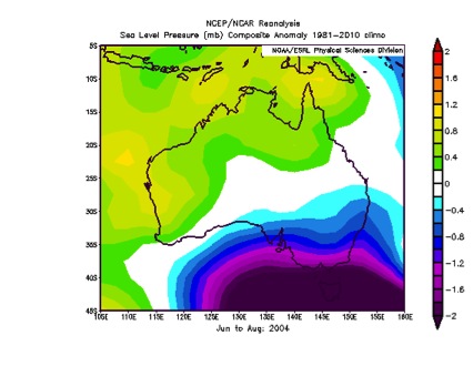
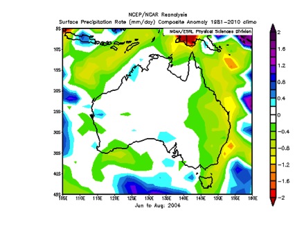
A recent example of a year that had lower than average pressures to the south is 2004, which as fate would have it was a weak (and disputed by some) El Nino year very similar to what we’re expecting this year. 2004 also happens to be the last year we cracked a snow base of 2 metres at Spencer’s Creek. The images below show the sea level pressure and rainfall anomalies from June to August 2004. That means the images are showing the difference between winter 2004 and the average of the last 30 years.
Note two things:
First, in addition to negative pressure anomalies (purple and blue) over south-eastern Australia in the first image there’s also higher pressures over northern and western parts of Australia, and so this would have increased pressure gradients and the westerly winds even more over the winter on average.
Second, the precipitation anomalies are actually negative (green colours). There was less precipitation than normal over the Alps, but thankfully a much larger proportion fell as snow.
So I quite like 2004 as an example of what we might be expecting this year. That year saw good snowfalls from mid-June to early July, a bit of a lull, and then solid August totals with the snowpack standing strong for all of September.
And that means it’s time to change my forecast for the season. Here’s what I think we can expect:
• An unspectacular start to the season, but at least it now looks like it will be a bit cooler than normal and not too bad for snow-making.
• The first big 30cm+ storm to occur in late June/early July (assuming the low this weekend doesn’t throw up a big surprise).
• Spencer’s Creek snow depth to break one metre by mid-to-late July, and to top out at 201cm.
As always it will come down to the random fluctuations of a few big storms that make the difference this winter, but it does look like things may be tipping in our favour. If you’ve got questions, feedback, or a bone to pick, hit me up at grasshoppermw@gmail.com or facebook.
Perisher forecasts,
snow reports and
live snow cams.
Falls Creek forecasts,
snow reports and
live snow cams.
Mount Buller forecasts,
snow reports and
live snow cams.
Hotham forecasts,
snow reports and
live snow cams.
Thredbo forecasts,
snow reports and
live snow cams.