Australian Forecast, Wednesday August 28th – High Altitude Snow Amid Wet and Windy Conditions
Mountainwatch | The Grasshopper
Published early Wednesday, 28th of August 2024
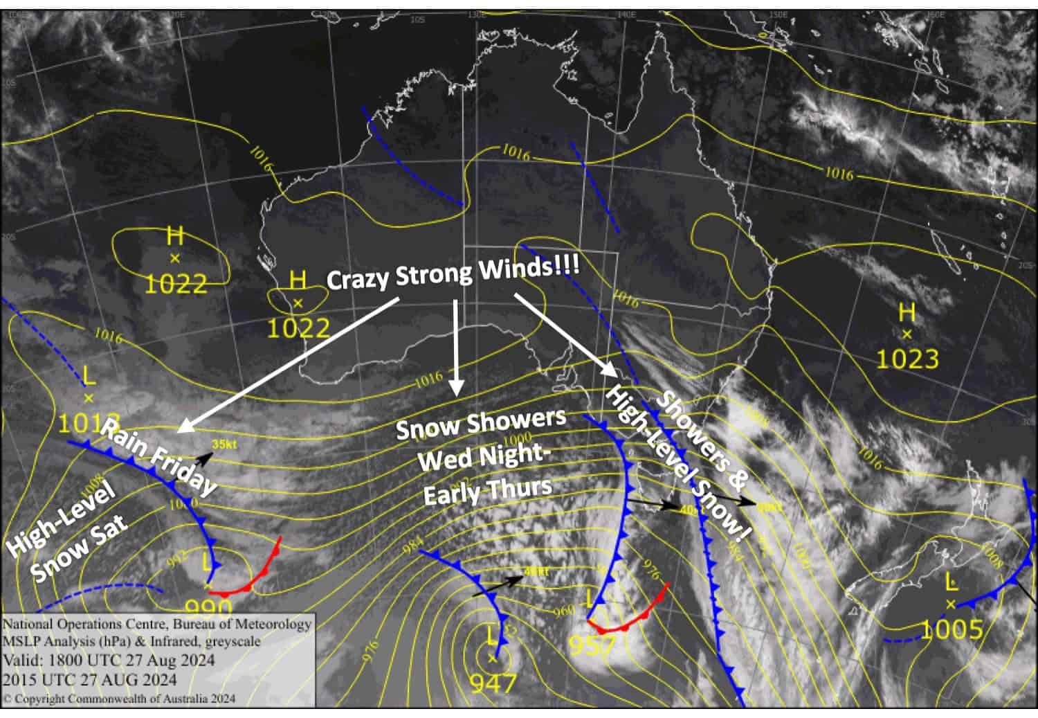
Boy, did it get windy last night. Wind gusts reached 128km/h at Thredbo Top Station! Winds will remain strong for the rest of the week, hampering lift operations, and wet conditions will continue to gnaw away at the snowpack.
Cooler air will arrive later today, Wednesday, allowing high-level snow to lower to near 1500m for a time Wednesday night and early Thursday. However, the bulk of the snow will fall at high altitudes, and throughout Wednesday and Thursday, we could see between 5-15cm accumulate up there with a light dusting lower down. Snow levels will dip down briefly again on Saturday, with another 10-15cm possible about the tops.
Our MountainWatch models reflect this snowfall at high altitudes, although they’re perhaps on the high side. Most of this, however, will fall as rain on mid and lower slopes below 1700 metres.
Wednesday August 28th
Strong northwesterlies reach gale to severe gale force in exposed areas, making life difficult in the mountains, so prepare for the worst. Showers in Victoria spread to New South Wales later in the morning, falling as snow above about 1800-1900m but gradually lowering to 1500-1600m in the evening.
Thursday August 29th
Light showers for Victoria, falling as snow to near 1500m at first, but lifting to 1800m or above in the morning. New South Wales will have a partly cloudy day. Strong to gale westerlies gradually turn northwest and back off a touch.
Friday August 30th
It’ll be a very rough day, with rain at times while severe northwesterlies gradually back off to gale force. Snow will fall above about 1800m at night.
Saturday 31st August
Showers throughout the day, with snow lowering to 1600-1700m briefly in the morning before lifting to around 1900m. Up to 10-15cm of snow could fall up top, reducing to naught down at base levels. Gale to severe gale northwesterlies in exposed areas.
Extended Forecast
Northwesterlies will continue to blow on Sunday while rain and high-level snow continues to fall, but a strong, cold southwest change on Monday should bring a little snow to base levels.
Strong northwest winds will likely return next Wednesday, September 4th, with a couple of bouts of rain thereafter as fronts pass over. Unfortunately, snow is nowhere to be seen next week
That’s all from me today, folks. The next forecast is Friday. See you then, and have a great couple of days.
Grasshopper


