New Zealand Forecast – Opening Days Likely with Cold Temps & Fresh Snow this Week
Published early Monday, 22nd June 2026
It got real ugly on Saturday as that strong northwest rainband whipped through. The Remarkables were hoping to open on Sunday, but the snowpack just took too much of a hammering, so they’ve had to delay again till conditions improve. Canterbury was perhaps worse affected, where winds reached 248km/h at Mt Hutt, only 8km/h shy of their all-time record!
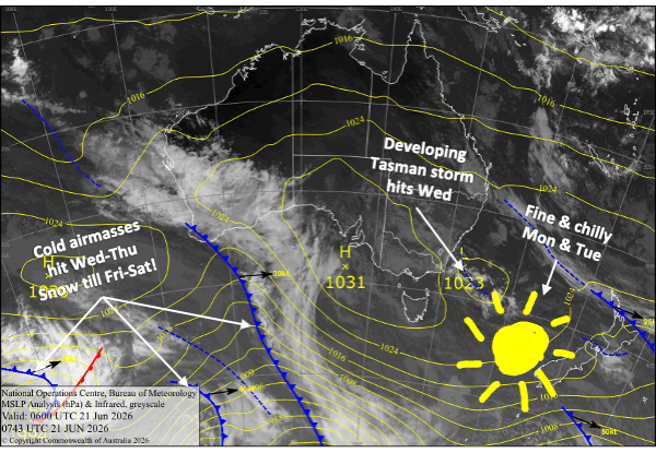
Without a doubt, it’s been a challenging start to winter, but conditions are set to improve significantly this week, which should allow ski fields to finally open. Cold temps arrived on Sunday, which allowed the snow guns to fire up, and that’ll continue through Monday and Tuesday as settled high pressure crosses the South Island.
The main focus of the week, however, is a Tasman storm that will hit the country on Wednesday. A cold airmass rushing up from the south will gradually turn rain to snow, and all Kiwi ski fields are expected to pick up a fresh coat of snow by the time the storm departs on Friday and Saturday.
Models aren’t well aligned on how the storm will play out, so snowfall totals vary widely. The Southern Lakes stand to receive anywhere between 5 and 30 cm, while Canterbury is likely to see figures between 20 and 50+ cm.
Whakapapa and Turoa on the North Island’s Mt Ruapehu are scheduled to open on the 4th of July, and will be chomping at the bit for any good news due to little natural snow. Fortunately, the storm will also turn cold there on Thursday, and ski fields are expected to receive 10-20+ cm through Friday into Saturday. From now on, I’ll keep a closer eye on incoming snowfall there.
Monday 22nd June
Clear sunny skies as high pressure crosses the South Island, allowing a light northwest breeze to develop. Cold temps morning and night will have the snow guns blazing.
Tuesday 23rd June
Fine for the South Island with just a bit of cloud about the place and a northwest breeze, which will be a touch stronger in Canterbury. Temps remain cold, especially for the Southern Lakes, so the snow guns will keep up the good fight.
Wednesday 24th June
A storm in the Tasman Sea moves onto the North Island and upper South Island, while a cold airmass moves up the South Island.
The Southern Lakes will pick up a dusting during the afternoon as the cold front passes over, turning northwest winds to the southwest and getting the snow guns started on what will be a prolonged run.
Meanwhile, rain spreads over Canterbury; most likely it’ll be light, with snow falling about the tops. The cold southerlies spread up the region overnight, bringing snowfall to low levels.
Thursday 25th June
An extra surge of cold southerly winds reaches the Southern Lakes early, bringing fresh snow to low levels throughout the day, possibly to 800m or less. However, the snowfall could be light and intermittent.
Snow will continue to fall in Canterbury throughout the day, with heavy falls possible overnight as southerly winds become strong.
Friday 26th June
Snowfall gradually eases and clears the South Island. This may happen early for the Southern Lakes and later for Canterbury. Cold south-to-southeast winds, which could be strong in Canterbury, also gradually ease.
Extended Forecast
The last remains of the storm clear out on Saturday, but there’s a chance Kiwi ski fields will see light snow showers on Sunday and Monday as a cold southerly works its way up the country.
High pressure then dominates at least through the first half of next week, bringing settled weather and good snow-making conditions. Storms are likely to return from later in the week, with promising signs for snow.
That’s all from me today, folks. I’m sending out NZ forecasts every Monday, Wednesday and Friday throughout the season. Have a great couple of days, and I’ll see you back here on Wednesday.
Grasshopper