Grasshopper’s North American 2025-2026 Snow Season Outlook – February Update
Mountainwatch | The Grasshopper
It’s been a truly mixed bag for North America this season, with some record high snowfalls in the Canadian Rockies during the early months and some record long snow droughts for some United States areas including Utah, Colorado and Oregon. Time to check what has happened so far this season, where we sit right now and what we can to expect for the rest of the season.
Short Term Focus
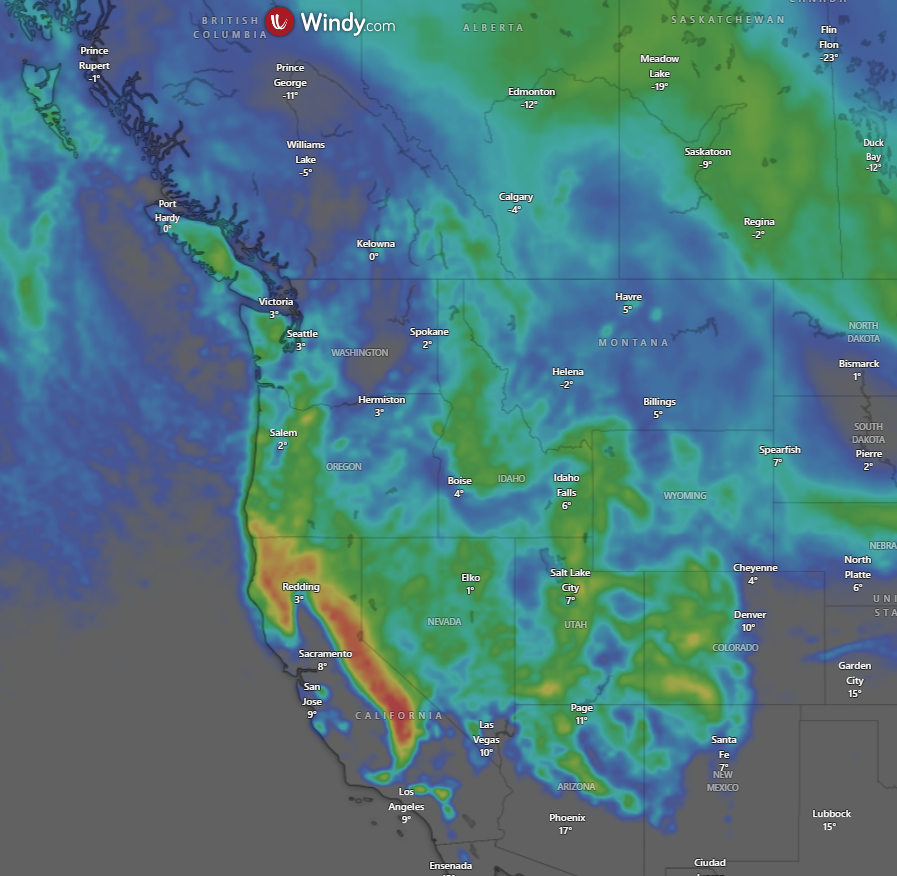
In the short term there is good news, with some fresh snow on the way for most mountain regions in the west, including sizeable accumulations for the Sierras where Palisades Tahoe and mammoth Mountain have already had huge totals in the past 24 hours. Below is the Windy five-day accumulation map from the European model showing a solid spread of falls with top amounts in the 100-150cm in the next 5 days and for the next 7 days 150-200cm (5 to 6.5 feet) in some Californian locations. For a more detailed talk on what is in store for the next week make sure to check my weekly North American forecast on Thursday.
Current Recap
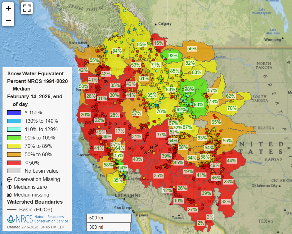
As mentioned, it has been a vastly different experience this winter depending on who you talk to and where they have been skiing and riding. The below graphic of snow water equivalent (SWE) percentage for many of the different basins across the Northwestern United States is a good indication of snowfalls this winter. An important note of this plot is that it takes a few observations from within the basin and then assigns the percentage colour to that entire basin.
So, for quite large basins we can see a few greenish dots in the Canadian Rockies for example, but the whole basin is yellow. Looking at the map spatially we can see a large amount of red throughout areas of the north/central west and southwestern areas. The storm track has been pushed further north leading to the long snow droughts mentioned but has managed to provide some relatively normal levels of snowfall through areas around the USA northern Rockies like the Tetons etc.
Climate Revisit
From our previous seasonal outlooks you might remember that a La Nina experienced this winter, will back to neutral values, possibly quite quickly. Currently we are still in a La Nina event but there are signs it has or is peaking and about to head back well into neutral conditions.
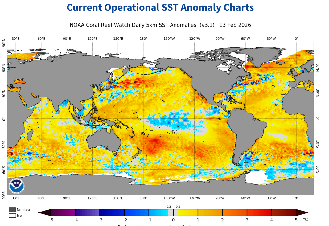
Below we have the global SST anomaly, and we can still see the presence of a La Nina signal with the cooler waters in the central equatorial Pacific and the warmer in western Pacific. An interesting note is that compared to past updates this signal does appear to be slightly weaker.
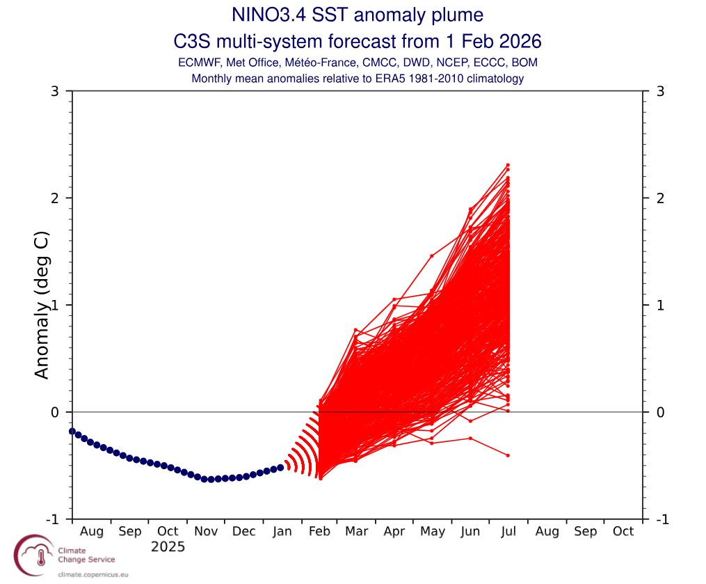
The forecast for the weakening of the La Nina event through February remains the most likely scenario with NOAA putting the probability of a return to ENSO neutral values at 75% chance before the end of March. Below is a plot featured in this season’s past updates showing the ensemble forecast of the SST in the Nino3.4 region. It appears this season’s La Nina event has bottomed out with values from every ensemble member increasing back towards neutral. A caveat for this graph is that predicting the state of the Nino3.4 region past the spring is notoriously difficult and is known as the spring predictability barrier. So simply focusing on the next few months a return to neutral is the most likely scenario, with a possible El Nino perhaps on the cards for next season.
Updated Seasonal Products
So, how will all this influence likely snowfall through the back end of the season? Below is a map of most likely category of MSLP through the March-April period. We are still seeing footprints of a La Nina in North America particularly with broad lower pressure over the equatorial Pacific and the high-pressure anomaly over the Aleutian Islands. This signifies a weakening of the Aleutian Low a common impact of a La Nina which is one of the reasons we see the northwards shift in the storm track over the western coast of North America.
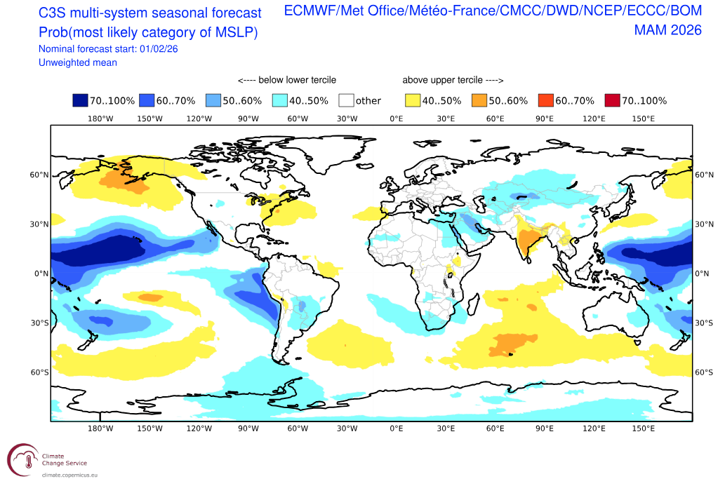
Three monthly forecast for probability of most likely category of MSLP for the March through May period. We can see some evidence of this winter’s La Nina event still having some impact. Source: Copernicus Climate Change Service.
The latest three-monthly outlooks from NOAA are next on the block with an important note that these include February and run to the end of April. Broadly we are seeing a picture that resembles that of previous updates and will appear quite similar to that of the SWE map we discussed at the start. Above average temperatures and below average precipitation the most likely outcome for areas broadly southwest of Oregon to Colorado, neutral conditions across the PNW and an area of cooler and wetter conditions northern areas like Montana. Again, it looks like the best conditions will be confined to further northern areas and particularly the northern Rockies.
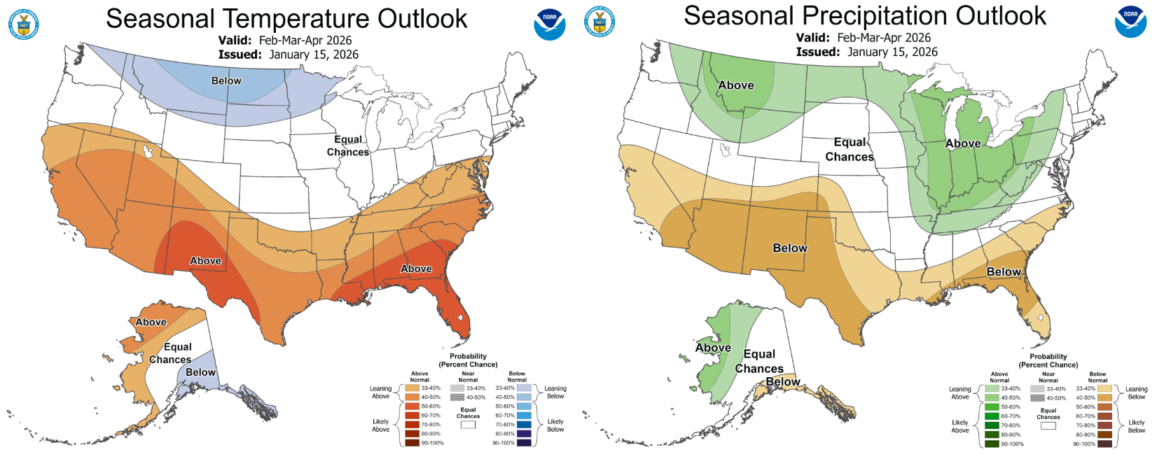
The NOAA seasonal forecast for temperature (left) and precipitation (right) over the February through April period. Source: NOAA
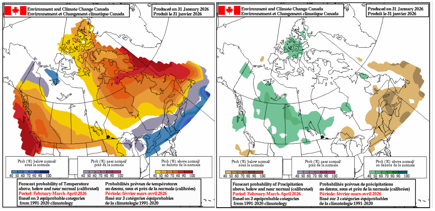
Looking north of the border now we have the same outlooks but from Environment Canada, again running to the end of April. Slightly above to above average temperatures across the southwest and that increased precipitation signal about the Rockies. Similar to past outlooks.
Wrapping it up
Overall as we head into the closing months of the 2025-2026 North American season our broader picture of the winter remains similar. La Nina waters in the Pacific look to ease back to neutral levels with still some lingering effects on the overarching global system that will continue to see the same areas favoured so far this winter for the remainder. The good news for many who have gone begging this season is some short-term accumulations getting quite healthy in areas of California but also some fresh snow reaching most of the forgotten areas over the next 10-day period.
For a more in depth look at the short term keep tuned to the North American weekly forecast updates.