Grasshopper’s North American 2025-2026 Season Outlook – December Update
Mountainwatch | The Grasshopper
We have made it to December with only a few weeks until Christmas and for many ski resorts “more snow” is on the top of their list to Santa. It has been a slow start to the season for across many North American resorts thanks to extended dry spells and mild temps hampering snowmaking efforts at lower elevations. So, let’s see what’s going on and if our theories from the last outlook remain or need any adjustments.
Current State of Affairs
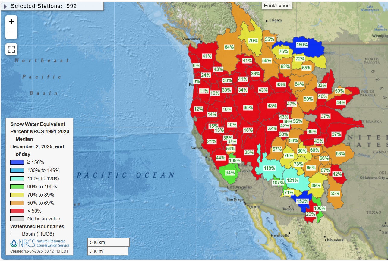
As mentioned, an extended dry spell in the west throughout some of the popular ski areas of the United States has been leaving many wanting. Below is a map of the snow water equivalent for many basins around the western United States. It colour codes that basin’s current measurements against the median value for that specific day from the 1991-2020 period. We can see a lot more reds than desired, but it is the first week of winter and one decent storm could change the complexion of this map dramatically.
Short term forecast
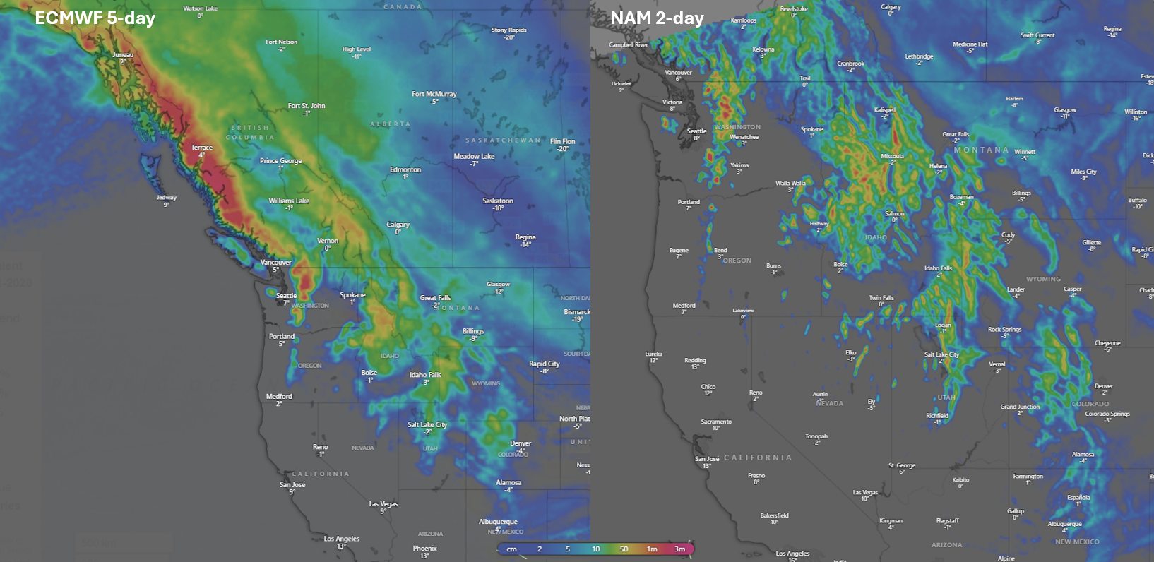
To quickly touch on the short term the good news is there is some snow on the way over the next few days, which is a welcome sign but unfortunately it does seem to miss certain areas. Below is a forecast snow accumulation map for the ECMWF model (widely considered one of the best) and the NAM model (a higher resolution model tuned for the most populated areas of North America). The map on the left shows the snow accumulations for the next 5 days while the right shows the accumulations for the next two days. They have similar patterns and BC’s Coast Mountains, the Canadian Rockies and areas like Montana/Idaho/Wyoming are well-placed as a trough orients itself through that corridor. It moves through further into the US with some snow also for Utah and Colorado areas. Unfortunately, a high-pressure system over California which will gradually weaken into a ridge deflects the storm system away from areas like Tahoe and the Sierras which will ultimately see settled conditions.
Pacific Check in
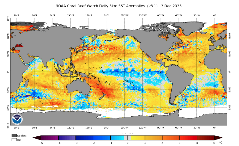
The Pacific Ocean is currently in La Niña conditions and we can see this characteristic pattern from the below daily SST anomaly (cooler Equatorial Pacific/collection of warmer waters in the Western Pacific). Remembering from our last update La Niña is typically good news for many resorts but importantly not all with the promotion of a northward shift in the storm track the pattern usually favours southwestern Canada areas and northwestern US areas. The most likely forecast remains for ENSO to return to neutral throughout the second half of the season.
Other Influences
Another influence not discussed last update but mentioned in the most recent Japanese outlook is the potential for a weakened polar vortex this winter promoting cold air outbreaks in the northern hemisphere. Keeping it brief in La Niña years there polar vortex is more likely to be weaker and this year another acronym in the meteorological landscape the QBO (quasi-biennial oscillation) is also acting to promote this which can lead to cold air outbreaks to higher latitudes through deviations to the polar jet, a fast moving current of air up in the atmosphere. The polar jet and these cold air outbreaks can bring sizable storms with them. For a more detailed deep dive on the potential for slow down events of the polar vortex in the Northern Hemisphere this winter see the most recent Japanese winter outlook here.
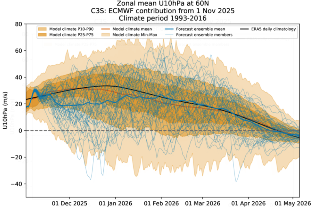
The chart below shows the forecasted zonal (east/west) wind strength in the upper atmosphere at 60 degrees north from the ECMWF model, which we can treat as a proxy for the polar vortex strength. The bold blue line shows the mean forecast this winter which is noticeably lower than the expected climatology through until the second half of winter.
Other Seasonal Forecasts
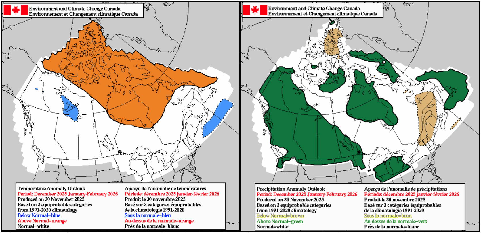
Below are the updated seasonal outlooks from NOAA and Environment Canada for the winter period showing a clearer La Niña pattern that we discussed in depth last update. Starting with the USA specifically, cooler/wetter conditions are most likely in the north/northwest while warmer/drier conditions are the most likely in the south/southwest. A similar pattern to the storm system expected over the coming days.
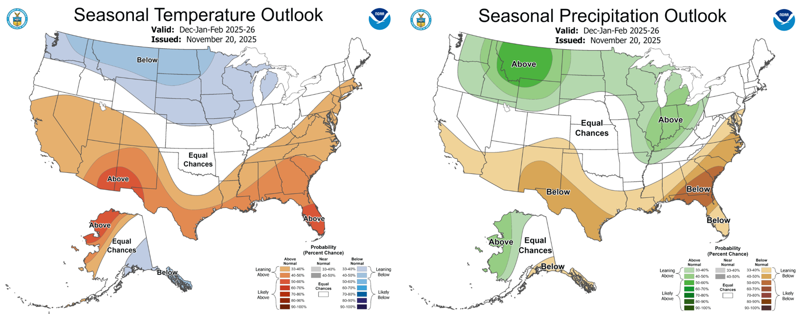
Looking at Canada, the Environment Canada outlook is in agreeance with our master plan, widespread chance of above average precipitation in the west associated withLa Niña influence and broadly neutral temperatures over the typical ski areas.
Waiting Game
As the season is just beginning many are waiting with nervous excitement for what’s to come. Some welcome snowfall will arrive over the coming days and moving further into the winter many resorts remain in line for solid seasons. Our most likely outlook remains the same with La Niña the main driver areas of northwestern US and southwestern Canada are best placed to benefit.
Stay tuned for my weekly North American forecasts, due to start soon.


