Grasshopper’s Weekly Japan Forecast, December 26th, 2024 – Another Deep Week Ahead as Relentless Storm Cycle Continue

Mountainwatch | The Grasshopper
Written Thursday morning, 26th December (Japan Standard Time)
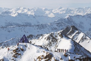
It’s been a very merry Christmas in Japan, where resorts in central Honshu had another deep week in what is becoming a bumper season. Reports from the base of Myoko chalked up over 180cm from the last 7 days, while most others in the region also scored more than a metre. Some resorts further north also scored big, with Geto and Niseko racking up 87cm and 43cm, respectively. In contrast, others in the north had a lighter week, with Zao and Furano receiving 28cm and 19cm, respectively.
The upcoming seven-day period will be deeper than the last for northern Honshu and Hokkaido, and perhaps the deepest one yet for central Honshu (and that’s saying something!) where it’ll often snow heavily. Breaks in snowfall will be few and far between as this relentless storm cycle continues. The most significant break is likely on Monday, offering a rare opportunity to score deep Japow under blue skies.

Thursday December 26th & Friday December 27th
Thursday starts with a warm south-southwest flow over the country while a pair of cold fronts approach from the Sea of Japan.
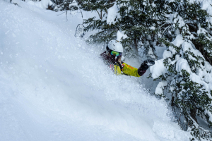
In the north, the two fronts have run into each other and are passing over Hokkaido and northern Honshu simultaneously, as I write, with heavy snowfall and plummeting snow levels. Once the front has passed over by late morning, frigid westerlies will bring persistent light-moderate falls of high-quality Japow all the way through Friday, adding up to a decent load.
Further south, there is more separation between the two fronts. The first will slowly inch its way over Central Honshu during daylight hours Thursday, bringing heavy snowfall to resorts exposed to a southwester, but also rain down low due to mild temps and elevated snow levels. The second, colder front arrives Thursday night, and we’ll see more widespread heavy snowfall eventually reaching base levels. The snow won’t start to ease until late Friday, by which time we’ll be looking at over a metre of fresh powder at some resorts.

Saturday December 28th & Sunday December 29th
The Japow Machine will continue chugging away throughout the weekend, with light-moderate snow showers continuing over Hokkaido and northern Honshu, thanks to persistent and cold west-to-northwest winds flowing off the continent.
Snowfall will pick up again over Central Honshu early Saturday, with moderate-heavy snowfall before things pin back late in the day and even clear that night. Another front will build offshore and then pass over the area during the second half of Sunday, bringing a short spell of moderate-heavy snowfall.

Monday 30th December to Wednesday January 1st J
Remaining snowfall over Honshu will clear early Monday, and clouds will part for some blue-sky powder turns. Light snow showers on Hokkaido will also eventually clear, and clouds will thin, although it may be wishful thinking to mention blue skies here.
A low-pressure system shooting over the Sea of Japan will spread snow down Honshu early Tuesday, with another round of moderate-heavy snowfall. However, it’ll initially fall as rain at low elevations until colder air arrives at night. The storm will gradually wind down and peter out on Wednesday.

The storm will mostly clip southern Hokkaido, with some decent snowfall there late Tuesday into early Wednesday before easing and becoming restricted to northern and western areas due to northerly winds in the lee of the low-pressure system.
That’s all from me today, folks. Have a great week, and I’ll see you here next Thursday for another weekly rundown of Japan’s highlights and snowlights.
Grasshopper