Japan Snow Wrap – Powder is on the way
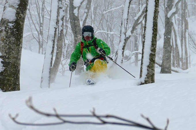
Dry fresh snow is a telemarking heaven. Hakuba Jan 4. Photo Steve Lee/Hakuba Backcountry Tours.
Mountainwatch | Reggae Elliss
The last week of December saw some hectic week of crowds in the major Japanese resorts, but things have mellowed a little now that the locals are back at work and school. The good news continues with good snowfalls in both the Hokkaido and Honshu resorts over the past couple of days and more snow is on the horizon. Reports from Niseko have been good with plenty of powder turns to be had on Jan 5, cold temps ensuring snow quality was light and dry.
Steve Lee, our Hakuba snow reporter had a great day yesterday, making the most of the 30cms of fresh snow, guiding his guests into some deep powder. Reading Steve’s report this morning you could tell he was pretty happy: “Cracking day on the way, lots of new snow after a full day of cold snowy weather yesterday and more into the night. The snow goddess has delivered! “
So far the Japanese winter has been a little stop start with extended periods of light snow and fine weather in between the big snowfalls, but as we head into January the expectation is Japan’s natural snow machine will kick in with regular big dumps.
That may be as soon as next week with both Hokkaido and Honshu expecting good snowfalls from Tuesday onwards.
ALSO READ: The Best Skis For Japan 2016-17
Yesterday’s snow came with strong winds and wind-hold for some lifts but the wind has dropped today, so it should be all lifts open. That also means plenty of cold, smoky powder out there with the possibility of blue skies this afternoon. The fine weather will continue across the weekend, but with a public holiday on Monday it will be a crowded couple of days.
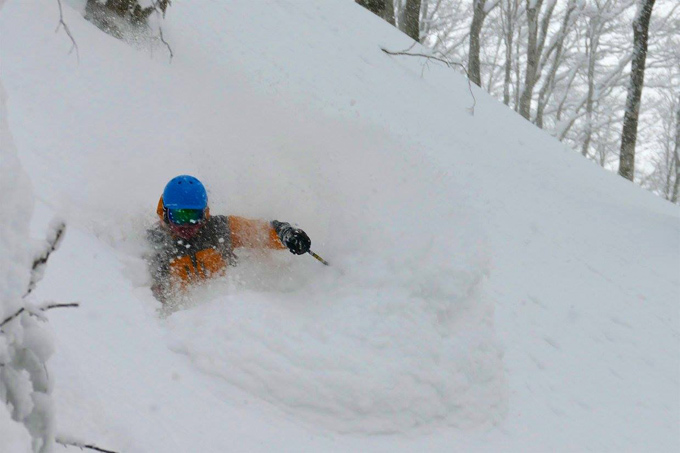
January 5 was one of the best days in Niesko for over a week thanks to a good dump mid-week. Photo: Photo courtesy Oyuki
As we mentioned earlier, it is looking like a great day in the Hakuba Valley, with fresh snow and sunshine. Steve Lee reports “Powder at every resort in the valley, deeper up the valley and powder-packed groomers everywhere.” The base is now sitting at 40cms on the lower slopes, but a healthy 190cms at the top. The next few days will be fine before the next system hits mid-week.
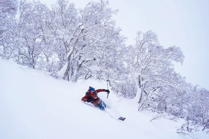
The official call was 30cms of fresh, but it was deeper in the trees. Photo Steve Lee/Hakuba backcountry tours
Cold and mainly clear in Furano today with temps down to -9. The groomed runs will be firm and fast, so an opportunity to work on your turns. Alternatively, there is still some untracked snow to be found in the back country, so a good day to take a guided tour. The good news is snow is on the way, with the forecasts calling for it to start on Monday night and continue through to late in the week.
IN THE FORECAST
There could be a rare burst of blue skies and sunshine this weekend before the next system moves in on Monday. At this stage the models are e showing 20-25cms by Thursday, but as we know this is Niseko and the intensity of the snowfalls is often above the forecast. The freezing level will flat line at an altitude of zero metres, which means quality snow at all elevations. Temps will drop as the storm takes hold with maximums of -10 on Wed/Thursday. The wind may be an issue, looking like 30-40kms/hr by the end of the week.
Sunshine tomorrow with a minimum of -13 before snow showers on Sunday afternoon. The freezing level may jump a little on Monday morning but then it’ll drop to below base level as the next storm kicks in. The Mountainwatch models are looking good with consistent snow from Monday night, the totals building as the week progresses. The wind is also looking OK at 15-25kms/hr out of the W/NW.
There has been some fun skiing the past few days around the Myoko resorts and while there is some cloud around today, the weekend shaping up as mainly fine. Myoko is directly in line for the next storm and the snow should start falling on Monday night. From then on it’s a run of powder days with temps well below zero, the kind of conditions you head for the trees for a day to remember.
Furano forecasts,
snow reports and
live snow cams.
Hakuba forecasts,
snow reports and
live snow cams.
Niseko forecasts,
snow reports and
live snow cams.
Yesterday’s snow came with strong winds and wind-hold for some lifts but the wind has dropped today, so it should be all lifts open. That also means plenty of cold, smoky powder out there with the possibility of blue skies this afternoon. The fine weather will continue across the weekend, but with a public holiday on Monday it will be a crowded couple of days.
January 5 was one of the best days in Niesko for over a week thanks to a good dump mid-week. Photo: Photo courtesy Oyuki
As we mentioned earlier, it is looking like a great day in the Hakuba Valley, with fresh snow and sunshine. Steve Lee reports “Powder at every resort in the valley, deeper up the valley and powder-packed groomers everywhere.” The base is now sitting at 40cms on the lower slopes, but a healthy 190cms at the top. The next few days will be fine before the next system hits mid-week.
The official call was 30cms of fresh, but it was deeper in the trees. Photo Steve Lee/Hakuba backcountry tours
Cold and mainly clear in Furano today with temps down to -9. The groomed runs will be firm and fast, so an opportunity to work on your turns. Alternatively, there is still some untracked snow to be found in the back country, so a good day to take a guided tour. The good news is snow is on the way, with the forecasts calling for it to start on Monday night and continue through to late in the week.
IN THE FORECAST
There could be a rare burst of blue skies and sunshine this weekend before the next system moves in on Monday. At this stage the models are e showing 20-25cms by Thursday, but as we know this is Niseko and the intensity of the snowfalls is often above the forecast. The freezing level will flat line at an altitude of zero metres, which means quality snow at all elevations. Temps will drop as the storm takes hold with maximums of -10 on Wed/Thursday. The wind may be an issue, looking like 30-40kms/hr by the end of the week.
Sunshine tomorrow with a minimum of -13 before snow showers on Sunday afternoon. The freezing level may jump a little on Monday morning but then it’ll drop to below base level as the next storm kicks in. The Mountainwatch models are looking good with consistent snow from Monday night, the totals building as the week progresses. The wind is also looking OK at 15-25kms/hr out of the W/NW.
There has been some fun skiing the past few days around the Myoko resorts and while there is some cloud around today, the weekend shaping up as mainly fine. Myoko is directly in line for the next storm and the snow should start falling on Monday night. From then on it’s a run of powder days with temps well below zero, the kind of conditions you head for the trees for a day to remember.
Furano forecasts,
snow reports and
live snow cams.
Hakuba forecasts,
snow reports and
live snow cams.
Niseko forecasts,
snow reports and
live snow cams.


