New Zealand Forecast – 15-30cm for Ruapehu Wednesday, a Dusting or Top-Up for the South Friday, But Temps Marginal at Base
Mountainwatch | The Grasshopper
Published early Wednesday 26th June 2024
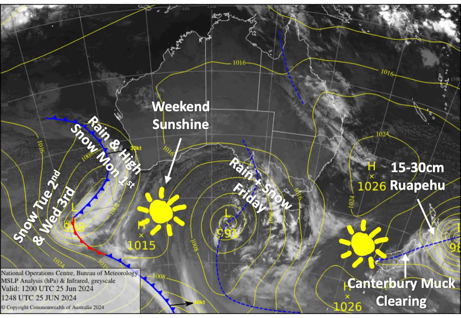
That low-pressure system that hung about in the Tasman Sea has finally disappeared only to be replaced by another, more intense one, which currently sits off the northeast tip of the country. Most of the weather will be over the North Island on Wednesday and Thursday as this new low gradually peels away. About 15-30cm is likely for the Mt Ruapehu resorts which is perfect timing as Whakapapa and Turoa are opening this Friday. Temperatures will be marginal at base levels mind you.
A front from the west passes over the Southern Lakes on Friday, bringing around 2-8cm to mid-upper slopes, although Treble Cone could score up to 15cm. The front will also give Canterbury a 1-5cm dusting up high Friday night. A ridge of high pressure will clear things up nicely for a mostly fine weekend, with some fresh snow to be found up high.
Wednesday 26th June
The Southern Lakes resorts will be sunny and calm above low-level clouds filling the valleys and basins.
Soupy conditions again for Canterbury as light E-NE breezes continue to push in low-level cloud and drizzle at times, limiting visibility. However, this might sink below base levels in the afternoon.
Thursday 27th June
A mint, sunny day for all South Island resorts, which will sit above low-level cloud down below. However, cloud will start to build over the Southern Lakes from afternoon as NW winds pick up.
Friday 28th June
Snowfall spreads over the Southern Lakes during the morning, with heavier, more persistent falls as a front passes over in the afternoon before clearing later. Temperatures will be marginal about the lower slopes, so it’ll either be rain or wet, dense snow there. NW winds will be fairly strong about the tops.
Canterbury will be fine, but high cloud will increase through the latter half of the day before the front also brings a little rain & high-level snow here in the evening. NW winds won’t be that strong.
Saturday 29th June
A nice fine day for all South Island resorts with a light SW breeze – perfect for Opening Day at Treble Cone. Any cloud or leftover precip affecting Canterbury will clear early.
Extended Forecast
The weather stays fine for Sunday 30th June. Then a front from the west will bring a mix of rain + mid-high level snow on Monday the 1st of July, followed by a cold southerly change on Tuesday the 2nd bringing snowfall to low levels through into Wednesday the 3rd. At this stage, snowfall accumulations are looking to be in the light-moderate range for the resorts.
That’s all from me today folks. The next forecast is Friday, see you then.
Grasshopper


