New Zealand Forecast, June 19th – Cloudy, Foggy Conditions Lift Late Thursday as Chilly NE Winds Ease
Mountainwatch | The Grasshopper
Published early Wednesday 19th June 2024
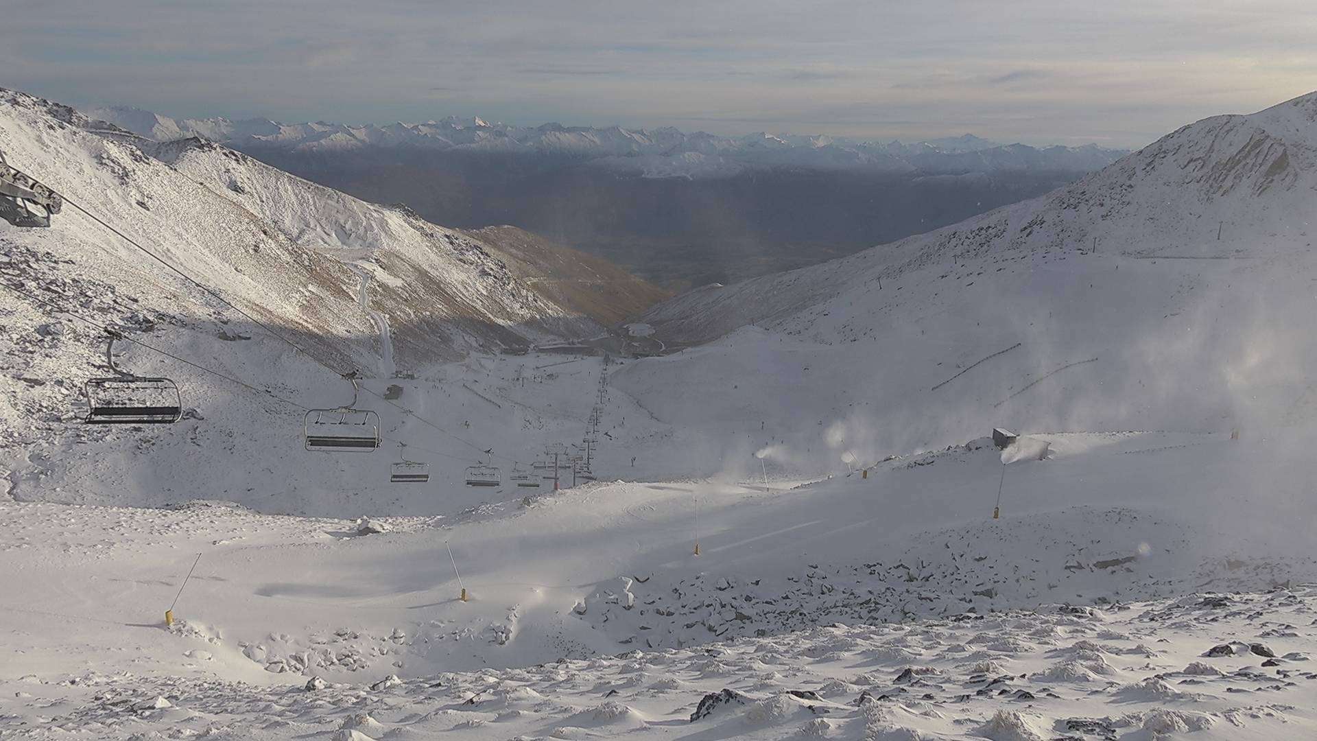
Coronet Peak opened yesterday, Tuesday, after receiving more light snowfall on Monday. Treble Cone is also looking good for their opening day on Saturday 29th June after picking up 15cm overnight Sunday. We’re still waiting on numbers to come in from Mt Hutt after about 25mm of precipitation fell about the Canterbury foothills yesterday – it doesn’t look like that has translated to much snow there. Additionally, chilly temps have allowed Kiwi resorts to keep the snow machines working round the clock as the New Zealand snowpack slowly builds.
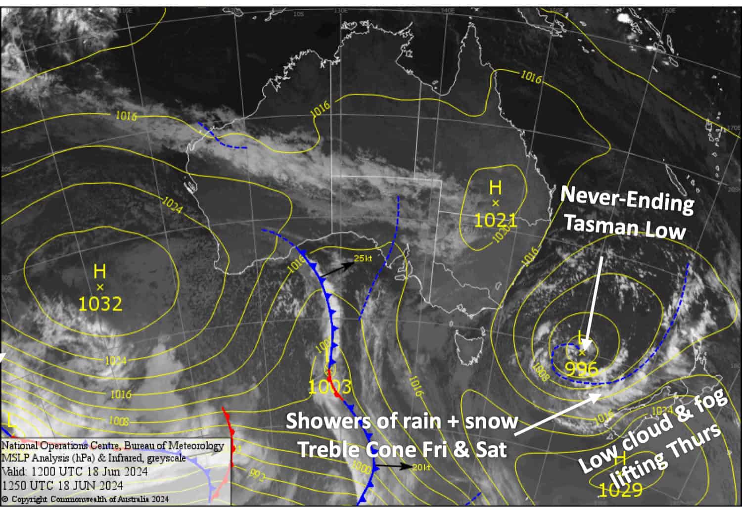
The never-ending low that arrived in the Tasman Sea last week Wednesday will continue to loll about there for the rest of this week and well into next week too. Cloudy, foggy conditions will lift later tomorrow, Thursday, as these chilly NE winds ease and turn northwards while the low weakens and drifts southwards closer to the bottom of the country.
Little will fall in the way of snow, although there’ll be light flurries about Mt Hutt today, and some showers of rain + high-level snow may spill over the Main Divide onto the Southern Lakes on Friday and Saturday which will most likely just hit Treble Cone.
Wednesday June 19th
A cloudy day for the South Island with fog-like conditions limiting the visibility at many resorts, especially in Canterbury where there’ll be light flurries from time to time at Mt Hutt. Chilly NE winds
Thursday June 20th
Chilly NE winds continue pushing in a lot of low-level cloud over the South Island, with foggy, low visibility conditions at most resorts throughout the morning, although the Queenstown resorts are likely to be less affected. The cloud will start to break up in the afternoon and visibility should improve, with some sun rays sneaking in.
Friday June 21st
Fairly cloudy for the Southern Lakes, more so at Treble Cone where there could be the odd shower of rain + high-level snow from afternoon. Northerly winds.
A fine day for Canterbury with just a little high cloud and a N-NW breeze developing.
Saturday June 22nd
A bit of cloud still over the South Island, especially at Treble Cone where there could be a few showers of rain + high-level snow. Mt Hutt will mostly be in the clear, however, with plenty of sunshine sneaking past a little high cloud. NW winds.
Extended Forecast
The never-ending Tasman Low may intensify for a time, pushing another NE rain band over the South Island anytime from late Sunday 23rd through to Tuesday 25th of June, bringing a bout of rain + snow to resorts.
The back half of next week could see the Tasman Low finally weaken and cross the country without too much weather and fanfare, only to have another weak system take its place. However, it’s still early days and I have low confidence in this scenario.
That’s all from me today folks. The next forecast is Wednesday, see you then.
Grasshopper


