New Zealand Forecast Weekend Forecast, June 28th – Freshies Today, Sunny Saturday, Ugly Sunday, Arctic Blast Monday

Mountainwatch | The Grasshopper
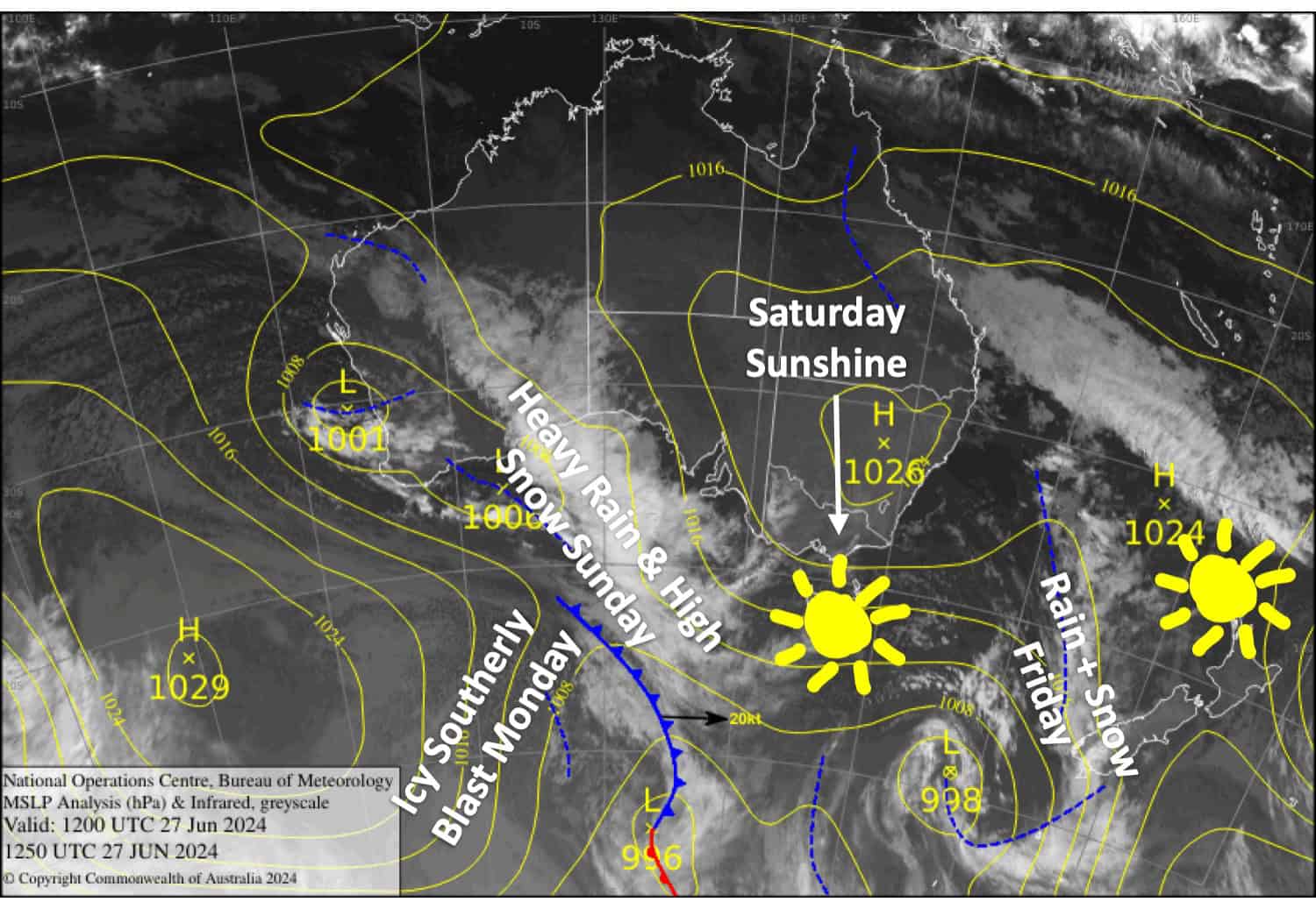
Published early Friday 27th June 2024
Today, Friday is Opening Day at Whakapapa and Turoa and fortunately, they’ve got a rare calm sunny day for it. Porter’s Pass were also hoping to open, but they need just a little more snow down low.
Treble Cone opens on Saturday and it should be an absolute cracker with sunny skies and a fresh 10-20cm layer of snow after a front goes through on Friday. The other resorts in the Southern Lakes are expected to pick up 2-10cm from this front, although temperatures will be marginal at base levels.
An even stronger front passes over the South Island during Sunday through Sunday night, bringing a heavy mix of rain, snow and gale NW winds. It’ll be ugly.
Then on Monday, a strong icy cold southerly straight out of Antarctica will blast up the South Island bringing a short sharp dump of snow followed by lighter snow showers. Canterbury in particular could do quite well out of this, hopefully getting Porter’s Pass over the line. There’s still a lot of uncertainty around this regarding timing and intensity and also snowfall amounts. So I’ll have the latest and greatest come Monday.
Friday June 28th
A bit rough for the Southern Lakes as a front from the west spreads snow over the area during the morning, then eases and clears from late afternoon. Temperatures will be marginal about the lower slopes, so it’ll either be rain or wet, dense snow there. NW winds will be fairly strong about the tops too, so come prepared for stormy conditions.
Not too bad a day in Canterbury where Porter’s Pass is scheduled to open, with just increasing high clouds. But the wind could be an issue as northwesterlies will strengthen throughout the day. The front reaches the area in the evening, giving the tops a light dusting of snow and a sprinkle of rain elsewhere.
Saturday June 29th
A mostly fine day for all South Island resorts as an S-SW breeze dies away – perfect for Opening Day at Treble Cone with freshies to be had. There’ll just be a bit of cloud in Canterbury during the morning.
Sunday June 30th
Rain and snow gradually spread up the South Island, most likely over the Southern Lakes during the afternoon where snow levels will be near, or slightly above, base altitudes, and then over Canterbury at night where snow levels may rocket up way too high for any snow. Once it arrives, the rain and snow will gradually become heavy. NW winds will also strengthen, likely becoming an issue as they rise to gale in exposed places.
Monday July 1st
Heavy rain clears Canterbury early while a few light snow showers linger about the Southern Lakes.
Then, a strong, icy cold southerly wind change will blast up the South Island, most likely in the afternoon, bringing an initial period of decent snowfall, especially in Canterbury, before quickly trailing off later/overnight.
Extended Forecast
Light snow showers from the southerly blast will likely continue over the South Island through Tuesday 2nd July, while the southerlies reach Ruapehu with snow showers also expected there for a day or so.
The following weekend of the 6th & 7th of July could bring another snowfall event, but we’ll have to wait closer to the time before counting on this one.
That’s all from me today folks. The next forecast is Monday, see you then.
Grasshopper


