New Zealand Weekend Forecast , Friday August 23rd – Series of Fronts Bring Heavy Precip and Strong Winds

Mountainwatch | The Grasshopper
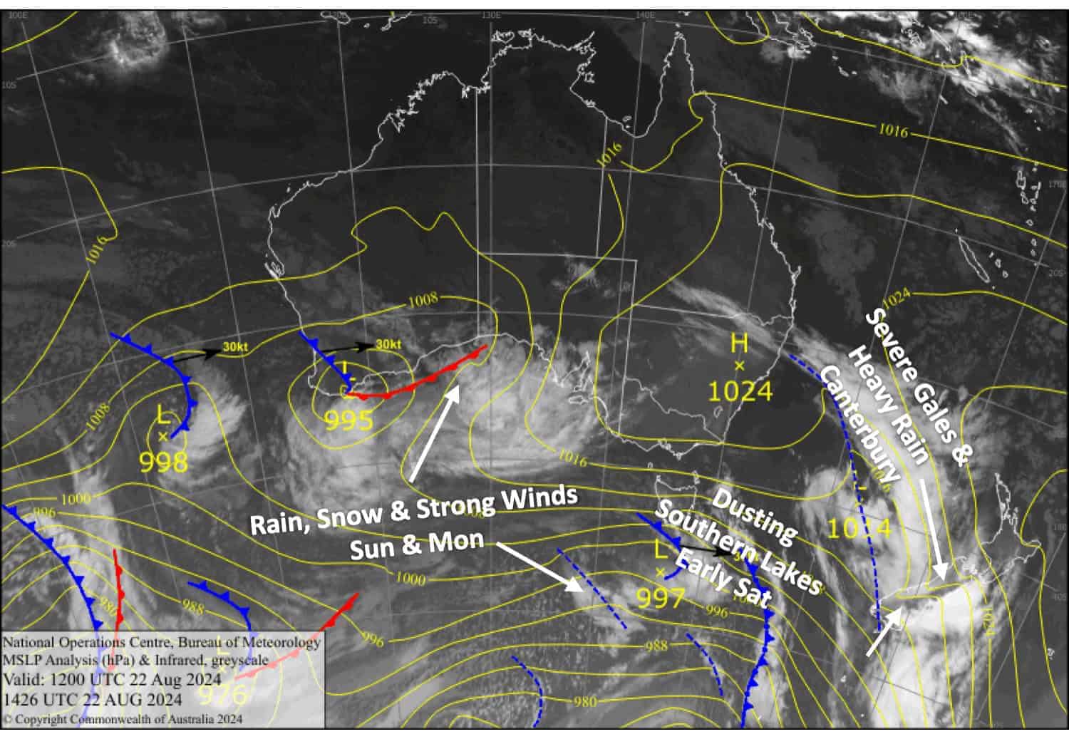
The bumpy ride continues as the weather remains unsettled for the next week or so. The first of a procession of frontal systems will slowly drift up mid and upper South Island today, Friday, then the North Island on Saturday, bringing heavy rain and gale-severe gale winds with it, especially to Canterbury today. A weak cold change will also give the Southern Lakes a dusting of snow early Saturday.
Another frontal system will bring heavy precipitation and strong winds to the South Island on Sunday and the North Island on Monday. Fortunately, this precip will fall as snow to or near base levels in the Southern Lakes and to about mid-slopes in Canterbury. However, the snow will be pretty low quality and dense. Models are still sketchy on details, so I’ve gone relatively broad-brush in the forecast.
Friday August 23rd
Partly cloudy for Southern Lakes with northwest breezes. We could see a few light showers, most likely on Treble Cone and Cardrona, which would fall as snow above about 1800m if they turn up.
A horrendous day for Canterbury, where we’ll have heavy rain and severe gale northwesterlies in exposed parts. This will cause a few headaches and no doubt limit operations. Some of that rain will fall as snow up high, and it’ll all start to ease in the south in the afternoon and elsewhere in the evening.
A cloudy day for Mt Ruapehu with light rain developing in the afternoon, falling as snow above 1800m, while northwesterlies rise to gale in exposed areas.
Saturday August 24th
Strong northwest winds for the South Island again, reaching gale force in exposed places, but it’ll be a mainly fine day apart from a little high cloud and some early snow showers about the mid-upper slopes of the Southern Lakes around dawn. Showers of rain and snow spread over most South Island resorts in the evening.
Rain on Ruapehu will be heavy for a time as a front passes over, turning strong-gale northwesterlies to a lighter westerly. The rain will fall as snow to mid-slopes and clear around evening.
Sunday August 25th
Snow is expected for South Island resorts, with heavy falls possible, especially for the Southern Lakes. The snow will be dense and may be wet on the lower slopes, particularly in Canterbury. Resorts closest to the Main Divide will see the most, while those in the east, such as Mt Hutt, will see significantly less. Strong northwest winds, gale force in Canterbury.
Mt Ruapehu will be partly cloudy with a spot of drizzle in the afternoon along with northwest winds.
Monday August 26th
A mainly fine day for South Island resorts, but northwest winds will strengthen again, rising to gale force in Canterbury.
A grotty one for Mt Ruapehu with rain and gale northwest winds.
Extended Forecast
The rest of next week still looks pretty gnarly. Northwesterlies will continue blowing like mad as fronts cross the country, bringing heavy rain and some high-level snow. Colder air should arrive towards the end of the week, so we could see at least a little snow making it down to mid or lower slopes. If you have plans for this week, I would watch the weather closely and be prepared for disruptions.
That’s all from me today, folks. The next forecast is Monday. See you then, and have a great weekend.
Grasshopper


