Weekly Japan Forecast, Friday January 16th – Long & Strong Storm Next Week
Mountainwatch | The Grasshopper
Written early Friday, 16th January (Japan Standard Time)
It’s been another big week in Japan, in which several days of heavy snowfall has dumped over 0.5-2m of powder across the country. Japan has certainly been making up for a slow start in recent weeks and is now fast approaching that elusive above-average mark.
We’ll see a bit more snow on Friday and this weekend as a couple of weaker low-pressure systems pass over the country, bringing a mix of rain and snow. However, the real news is all about a long and strong storm that’ll dump a massive load of Japow over the country from early Tuesday. The storm will last several days, and Central Honshu in particular will see heavy falls and deep, deep totals. After this one, chances are, we’ll be sitting nice and lofty above the average mark.
Friday January 16th to Sunday January 18th
Yesterday, Thursday, snowfall in northern Honshu gradually built while transitioning to rain at lower levels, as milder southwesterlies arrived ahead of a low-pressure system. The belt of rain and snow pushed south over central Honshu late in the day, although here snow levels were even higher, like above 1200-1400m, so it was mucky stuff.
Fortunately, the low crossed the country last night, dragging in cooler west-to-northwest winds behind it and allowing snow levels to drop significantly. Snowfall over the Nagano Prefecture and areas to the south/west will dry up this Friday morning, but light falls will continue further north, including flurries on Hokkaido, though they will become fewer and farther between later in the day.
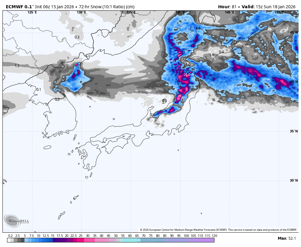
Thursday and Friday’s pattern repeats this weekend, with another low from the west crossing Honshu on Saturday. However, we can expect a more favourable result, especially for central Honshu, where around 10-25cm should fall. Temperatures and snow levels will be colder, both ahead of and after the low, and there’ll be less rain involved. Models are more at odds as to how much powder will fall over Northern Honshu and Hokkaido this weekend, but we should be looking at similar totals.
Monday January 19th to Thursday January 20th
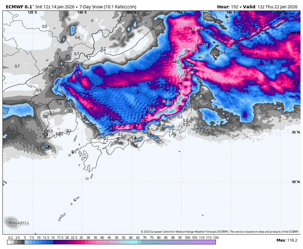
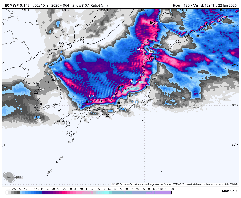
The next storm that hits Japan during this period will likely be the biggest and longest of the season so far. The storm starts ramping up late Monday, but, as usual, things start off warm in central Honshu. However, cold winds off the continent will hit the country early Tuesday and will continue through to at least Sunday, Jan 25th, bringing a massive load of high-quality Japow.
The snow will absolutely puke down over Central Honshu, where storm tallies are likely to be nearing the one metre mark in some areas by the end of Thursday. Snowfall will taper off to the north, but we could still see half a metre or more in some areas of northern Honshu and Hokkaido by the same time. So much snow is bound to create operational headaches and avalanche risks, so keep an eye on them.
That’s all from me today, folks. Have a great week, and I’ll see you here next Thursday for another weekly rundown of Japan’s highlights and snowlights.
Grasshopper


