SEASON OUTLOOK – On Track, An August Update
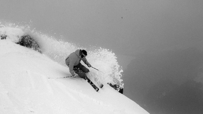
A turn to be remembered, Falls Creek July 26 Image:: Courtesy of Falls Creek
Season Outlook | The Grasshopper
Brought to you by ESS Boardstores
It’s been snowing in the Aussie Alps this week and we’re nearing the mid-way point of the season. I’m starting to field emails, tweets and facebook messages asking me what we can expect out of August and September, so what better time to update our seasonal outlook and take a squiz at the winter that’s been and the winter to come.
Rearview Mirror
In the April edition of the outlook I was feeling pretty neutral about the prospects for the year, picking a peak snow depth of 170cm at Spencer’s Creek in the Snowy Mountains, just shy of their long term median of 176cm.
Then in May I upped my forecast of maximum snow depth at Spencer’s to 201cm. This was because of a signal for some increased low pressure activity about and south of the Aussie Alps.
In June I stuck to my guns, predicting that we’d “pick up snow 10 to 20cm at a time.”
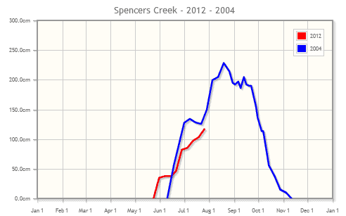
In May and June I also compared this year, with its growing El Nino, to 2004, a similar year and the last time we cracked 2 metres at Spencers Creek. 2004 saw less rainfall than average, but more snow. So how are we tracking? The image below shows that on July 26 we were just a little bit behind 2004 in terms of snow base and as expected we’re picking up snow very gradually.
The Eighth Month
That leaves us to talk about the rest of August and September. For the next fortnight I think we’re going to see more of what we’ve seen during July. That is to say, high pressure systems will dominate and when we get fronts coming through they will be solid but not spectacular.
Part of my reasoning is that global climate models are continuing to forecast above average surface pressures south-west of Australia. The growing El Nino will also help to maintain the subtropical ridge that runs west to east across central Australia during winter.
That’s likely to continue the present flavour of the weather patterns, and I’m pretty happy with that because although it doesn’t promise huge powder days it reduces the odds of big wet rainy events that could send the year backwards in a big way.
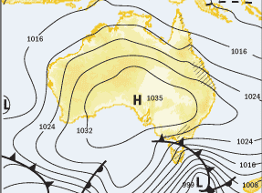
It doesn’t hurt here to re-use this example from the last outlook of what a typical front will look like over the next few weeks. The cold front you can see that is just about to pass over south-east Australia doesn’t have much in it, maybe 5 to 10mm/cm. But that high will have been feeding in cooler westerlies ahead of the front so when it does arrive, the balance will be tipped towards snow rather than rain.
The Grasshopper’s Gut
There’s something else. Call it insect’s intuition. Call it a balls to the wall gamble. Whatever you call it I’ve got this nagging idea that some time from mid to late August we’ll get one more really decent storm that lays down a good half metre over a couple of days. At some point I feel the see-saw has got to flip, these high pressure systems will fade for a week, and we’ll get a big outbreak of low pressure from the Southern Ocean and a monster westerly.
That would set us up nicely for September, where I think the high pressure systems will still be winning the arm wrestle on average and keeping conditions a touch cooler than usual, meaning that when the spring westerlies arrive we should pick up just enough snow out of each front to counteract the losses from the preceding rain.
With all that optimism I’m going to stick with my prediction of 201cm peak snow depth at Spencers Creek. I say that knowing that this whole season could quickly fall apart with just a couple of nasty rain events. The above is just my best guess given all the factors I see affecting the climate over the next two months. If you’ve got questions, feedback, or a bone to pick, hit me up at grasshoppermw@gmail.com or facebook.


