2025 Australian Snow Season Outlook – Grasshopper’s Mid-Season Update
Mountainwatch | The Grasshopper
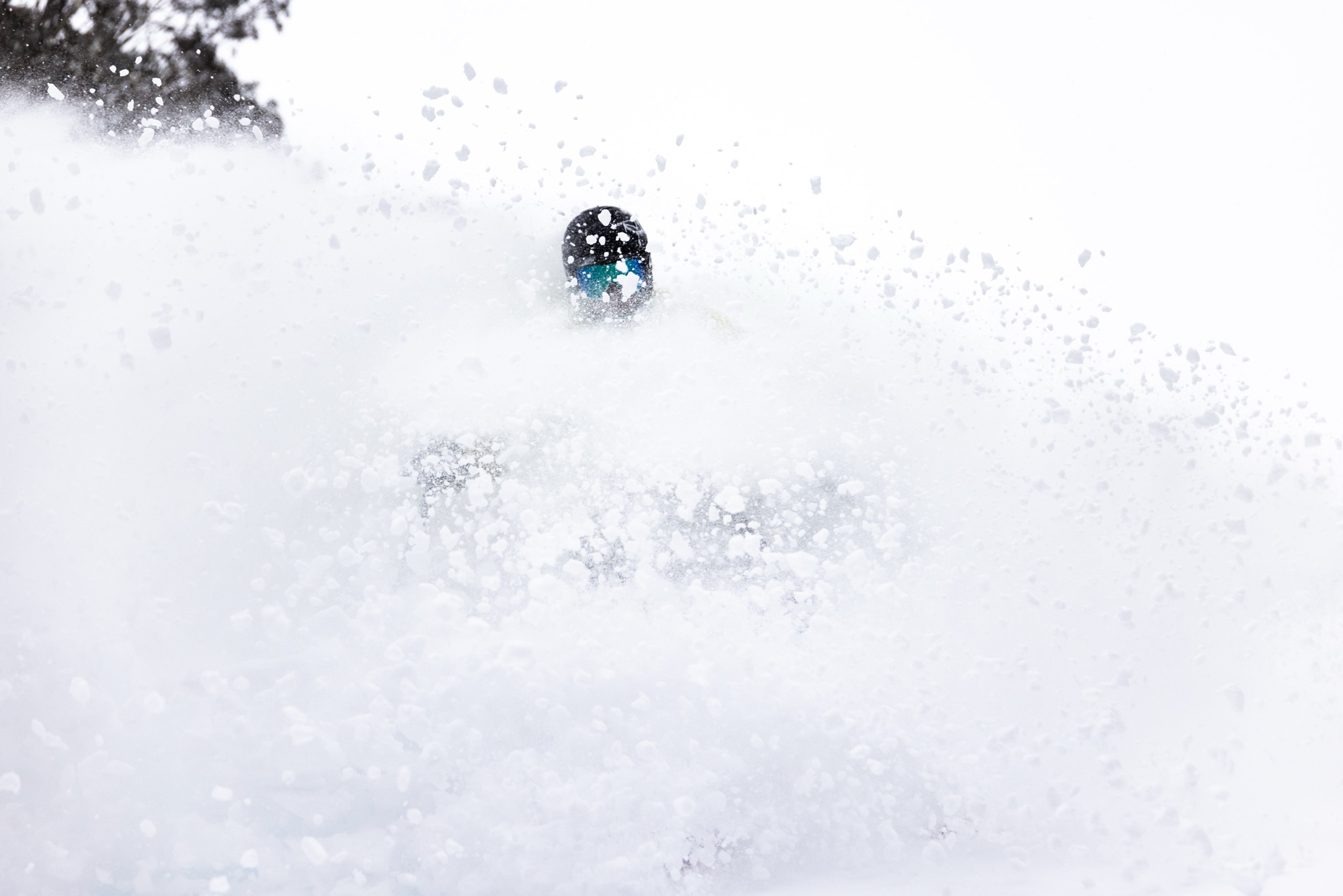
From humble beginnings with a somewhat bleak initial outlook for the winter some sizable storms across the Australian Alps have resulted in some of the best days in recent memory. This trend continued across the weekend although the snow quality wasn’t as good as earlier storms, with wet show falling at higher elevations – above 1600m – and rain below that.
The four-day accumulations will vary, dependent on location, but higher-end totals above 40cm are looking promising for the upper terrain in the major resorts the time by the time the snow showers ease Monday afternoon.
As for the season ooutlook as we hit the mid-season mark, let’s look at what has happened and what is predicted to happen for the second half of the Aussie winter season.
New Year New Me
Up until now the Australian resorts have seen some relatively regular storms gradually build bases to one metre. Some rain mixed in has dampened the potential of a few fronts that rolled through but overall, the season is building solidly, especially thinking back to last season.
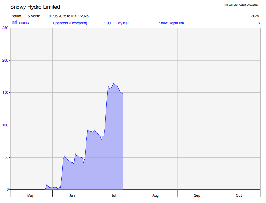
Below is a visual of the snow depth at Spencer’s Creek measured by Snowy Hydro and located in the NSW’s Main Range. The measurement is at1830m and is commonly used as a proxy for snow depth during the Aus season. We can see a steady building thanks to relatively frequent fronts delivering snow to the alps. Last year the back half of the season was not something to write home about but as we have been hinting in the outlooks for 2025, the back half of this season may be a different story. Time to dive into that below.
State of Drivers
Pacific Ocean
As alluded to initially the Pacific Ocean is sitting in a very much neutral state with no heavy influence on the Australian climate. Another feature of the SST (Sea Surface Temperature) environment is that the waters surrounding Australia are still historically warm with the second warmest June on record. Also, every month since July 2024 to last June the SST has been either the warmest or second warmest on record for that specific month. The reason this is important is because it can act to drive up terrestrial temperatures over Australia and which may lead to more rain than snow in a marginal situation.
Indian Ocean Dipole
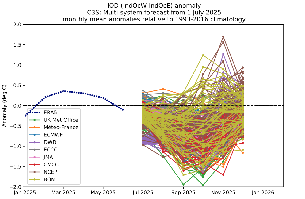
From previous seasonal outlooks you might remember I mentioned the likelihood of a negative swing in the IOD through the back end of the season. The IOD remains neutral but that swing negative in the coming months is becoming increasingly forecasted. The plot below shows an updated spaghetti plot illustrating possible modelled forecasts for the IOD index throughout the remainder of the year. We can see a likely negative peak through the end of the southern hemisphere winter before a return to neutral.
Connecting the Dots
Heading into the back end of the season we are getting a relatively clear picture of a negative IOD event developing. In earlier updates we discussed how this lends itself to an increased chance of precipitation over for east/southeastern Australia through an influx of moisture available thanks to warmer SST collecting to the northwest of the country.
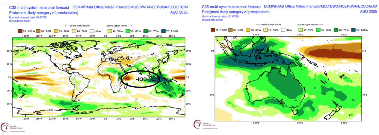
We can see this clearly in the graphic below produced by the Copernicus Climate Change Service showing global three-monthly precipitation probabilities. The figure below shows a global map on the left and a zoomed in version of the Australasian region. The negative IOD pattern outlined is immediately obvious in the global plot with forecasted below average precipitation in the western Indian Ocean and increased in the east. A good sign looking at the increased probability of above average precipitation over much of the Australian continent.
Below we have three-month August-October products from the BOM. We can see that increased chance of precipitation visualised but also see a high chance of warmer than average temperatures, a theme of all the Australian seasonal outlooks this season.
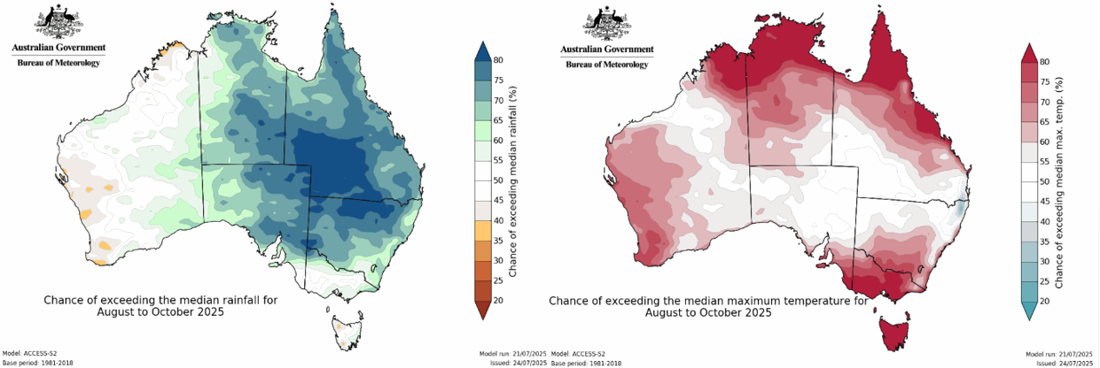
You might be thinking, but “Hopper it’s been pretty cold this year are you sure that’s right?” The answer to this question is a diplomatic yes and yes. We haven’t quite seen the doom and gloom temperature forecasts with very high chances of exceeding the maximum temperature from initial outlooks. Looking at data from June only (because we haven’t quite gotten through July yet), the maximum temperature was around average and the minimums below to very much below average.
Now you’re sceptical. It has been closer to average thus far over the Alps, so why won’t it continue to be? That is a more complex question, and the answer is tied into the weather than we have seen over the past two months. Repeated fronts hit the Alps with intense high-pressure systems helping drive more cold air up from the south with these systems. This differs from the forecasted neutral to below average precipitation forecast which was initially the plan for the first half of the season. But one of the big factors promoting warmer temperatures is the warm waters surrounding Australia over the past year and since there has been no real reprieve, this is still one big driver.
How do I know you can deliver?
You don’t, but I can. The picture for the back end of the season has been consistent with a negative IOD event becoming increasingly likely. The seasonal outputs from global are evolving to reflect this by painting increased levels of precipitation over Australia. Though we have just spoken about how temperatures remained mainly average through the season so far, there is still the worry that warm temperatures may be a feature possibly confining best conditions to during active storm cycles (which is often the case in Aus anyway). But the stage is set for a productive second half with solid bases built at many resorts. All that’s left is to wait and see and hope we can keep any warm spells at bay.
Stay across any incoming storms via my Australian snow forecasts every Monday, Wednesday and Friday while our on the ground independent snow reporters keep you up to date on daily conditions with their accurate and honest reports.
That’s it from me folks. If you’ve got a different theory on what’s going to happen this winter, or just want to provide feedback, then please hit me up on Facebook and hit the follow button while you’re at it.


