Grasshopper’s New Zealand 2026 Snow Season Outlook – Mid-season Update
Mountainwatch | The Grasshopper
Moving into the second half of the winter season the last few weeks have seen an improvement with consistent top ups and cold temps. With a storm moving through as we speak and some more snowfalls this weekend things keep ticking along. The storm window is likely to open up again next weekend, with the leading front likely to make landfall on the South Island on Sunday, the 23rd of August. Check my latest forecast for the details. A s we are wait for that system, let’s have look at what we can expect through the back end of the season .
Climate Recap
By now it needs no introduction that we are in an El Niño event this year, with the event tipped to break records in being the highest recorded SSTs ever and not by any small margin. For some reference before this year the strongest recorded El Niño came in 2015-2016 with SST anomalies in the Nino3.4 region maxing out at around 3.0°C. However this year the maximum SST anomaly is forecasted to be in the 3.5-4.0°C range. A clear outlier and what’s been dubbed a “Super” El Niño event.
It is also worth noting this year was also the earliest event declared by Australia’s BOM and with ENSO phases typically peaking in the December-February period it is still on the rise. Below is a current map of the global SST anomaly and the central-equatorial Pacific immediately stands out with warmer temperatures reaching closer and closer to the hotter ‘pointy’ end of the scale. The cooler waters in the western Pacific are also noticeable which should come as no surprise.
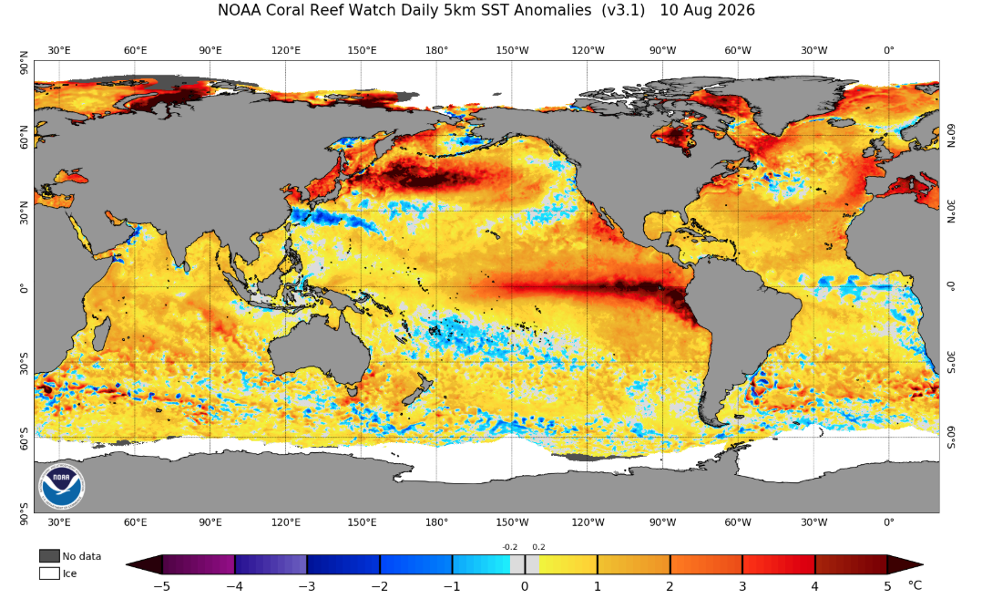
Global SST anomalies showing an obvious El Niño signal across the equatorial Pacific. Source: NOAA.
Seasonal Products
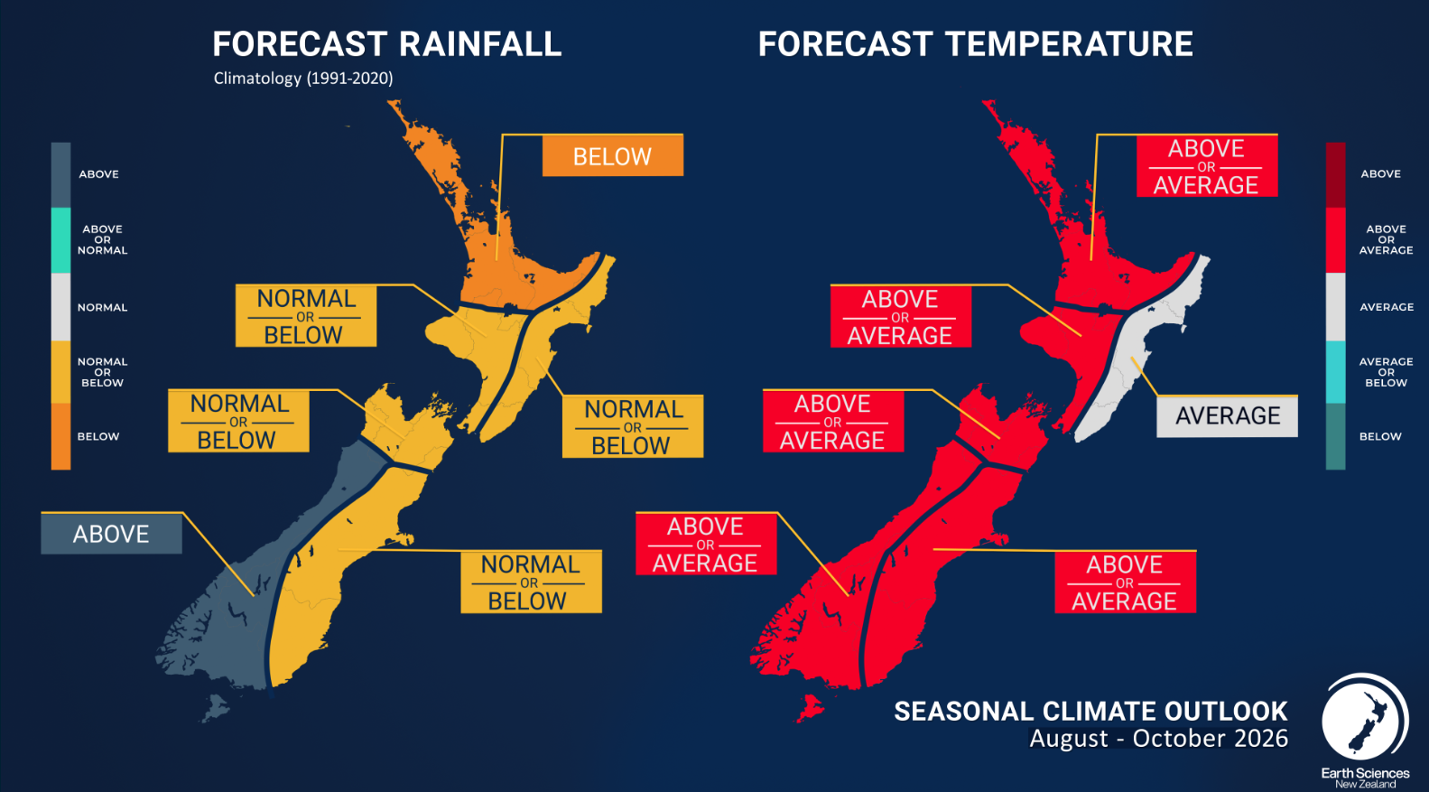
Looking at NIWA’s (National Institute of Water and Atmospheric Research) outlook now we can see a story that we would usually expect in a traditional El Niño pattern. Precipitation is largely normal to below with the North Island faring the worst. But for western areas of the South Island the precipitation outlook remains above normal. For temperature across the country the most likely outcome is for average to above average temperatures.
The answer to why western areas of the South Island are the outlier in the precipitation outlook is due to the expected pressure pattern during an El Niño event. We have touched on this point in prior outlooks but although ENSO phases do not have the same level of impact on NZ seasonal variability as somewhere like Australia, the traditional pressure patterns provide is with clues as to what is the most likely outcome (particularly when the pattern is strong or well pronounced).
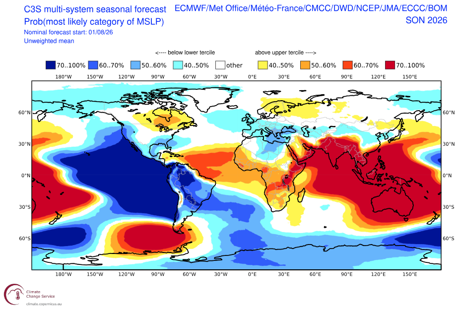
Below we can see the most likely category of MSLP for the next three months through to the end of October. We can see a large area of high pressure across Southeast Asia/Australasia while a low-pressure area sits south of New Zealand in the Southern Ocean. This pattern promotes a southwesterly regime across New Zealand which in turn promotes moist onshore winds for western areas of the South Island, hence one reason why we see an above average chance for precipitation over the period.
Wrapping it up
With a dominant ENSO phase, the talk of the town and having been the talk of the town since the start of the year, it is no surprise our main story for the NZ outlook remains unchanged. ENSO’s impact on New Zealand snow seasons is not as clear cut as it’s trans-Tasman neighbour but favoured by the predicted pressure pattern areas to the west/southwest of the South Island are typically best placed during an El Niño event.
A minor cause for alarm is that widespread areas see a chance for warmer than normal temperatures across the remainder of the season, potentially restricting best snowfalls to higher elevations and possibly seeking to keep a lid on the duration of the season as temperatures seasonally warm up. Overall if broad high pressures don’t extend too far South of the Australian mainland areas of the South Island can fare quite well with Southern Ocean storms dragged up north below these broad highs.
Stay up to date on short-term forecast through my regular New Zealand forecasts on Monday, Wednesday and Friday.