The Grasshopper’s 2026-27 Japan Snow Season Outlook – Super El Niño Points to Average to Below Average Winter
Mountainwatch| The Grasshopper
We are back. Things are warming up in the Southern Hemisphere after a winter to forget in Australia but one that’s still going in New Zealand, and our attention now turns to the North. If you have been keeping up with the state of the climate this year, you’ll already know the words of the year are Super El Niño. But what does that really mean for our chances of getting some of Japan’s finest turns this winter? That is the golden question. Let’s unpack it below.
Setting the stage
So, before we get into it, we need to recap where climate drivers are sitting at the moment. There is currently a record Super El Niño underway in the Pacific, dominating the scene. Below is a recent global SST anomaly map, and it doesn’t take long to see what’s happening. The obvious El Niño signal in the Pacific is immediately clear, with the almost off-the-scale warm waters throughout the central/eastern equatorial Pacific and cooler waters collecting in the west.
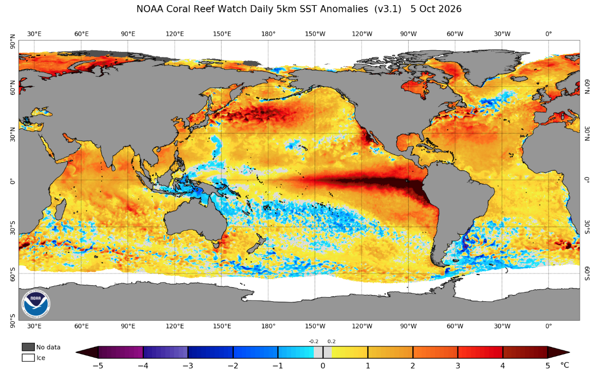
This year’s El Niño event broke records by being the earliest ever declared, which means that heading into the Northern Hemisphere winter, the atmospheric conditions are already very much exhibiting formed El Niño behaviour, something that is not regularly the case. ENSO events typically peak over the Northern Hemisphere winter, so with an already formed event so early and so strong, is it going to be able to persist?
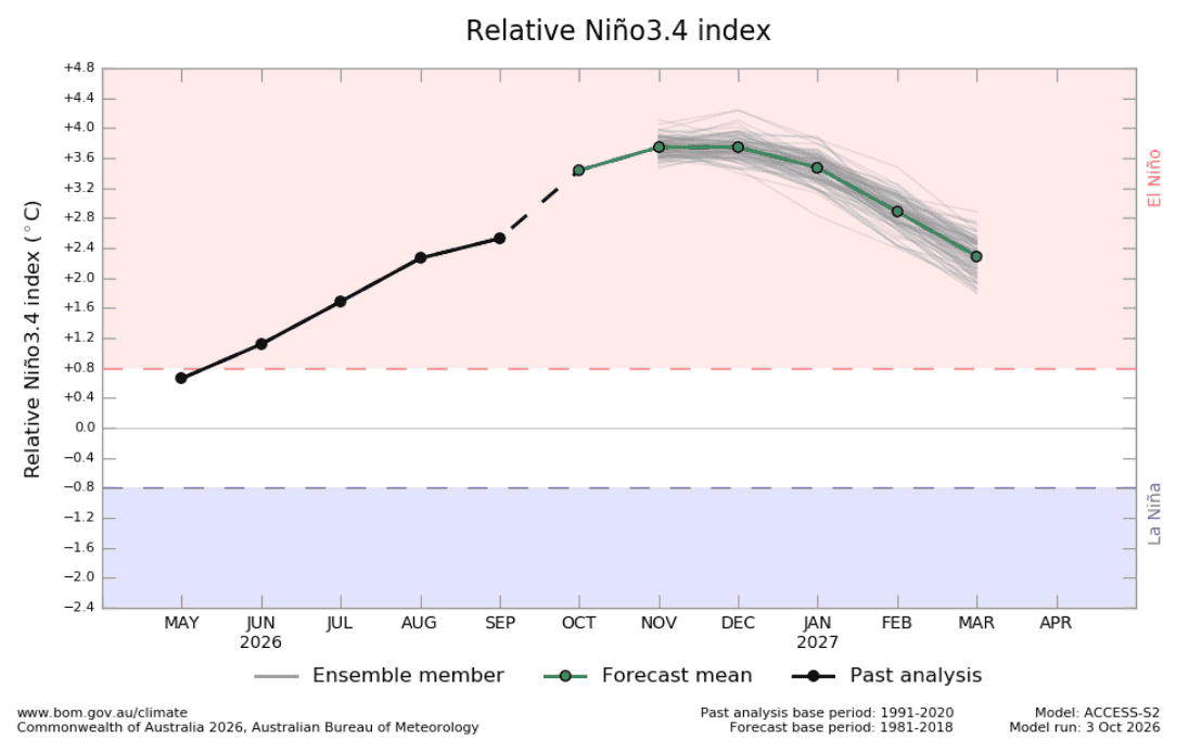
Well, I’m glad you asked. I have two figures to speak to this. The first, below, shows us the evolution of this year’s Niño3.4 index to this point, with the BOM’s best guess as to where it will head from now on. The area in red, highlighted above 0.8°C, is the BOM’s El Niño threshold for the Niño3.4 index (among some other atmospheric conditions), showing us that early formation just mentioned. But to the question of when it will peak, we can see the curve maxing out in the November/December period and then steadily declining for the remainder of the winter.
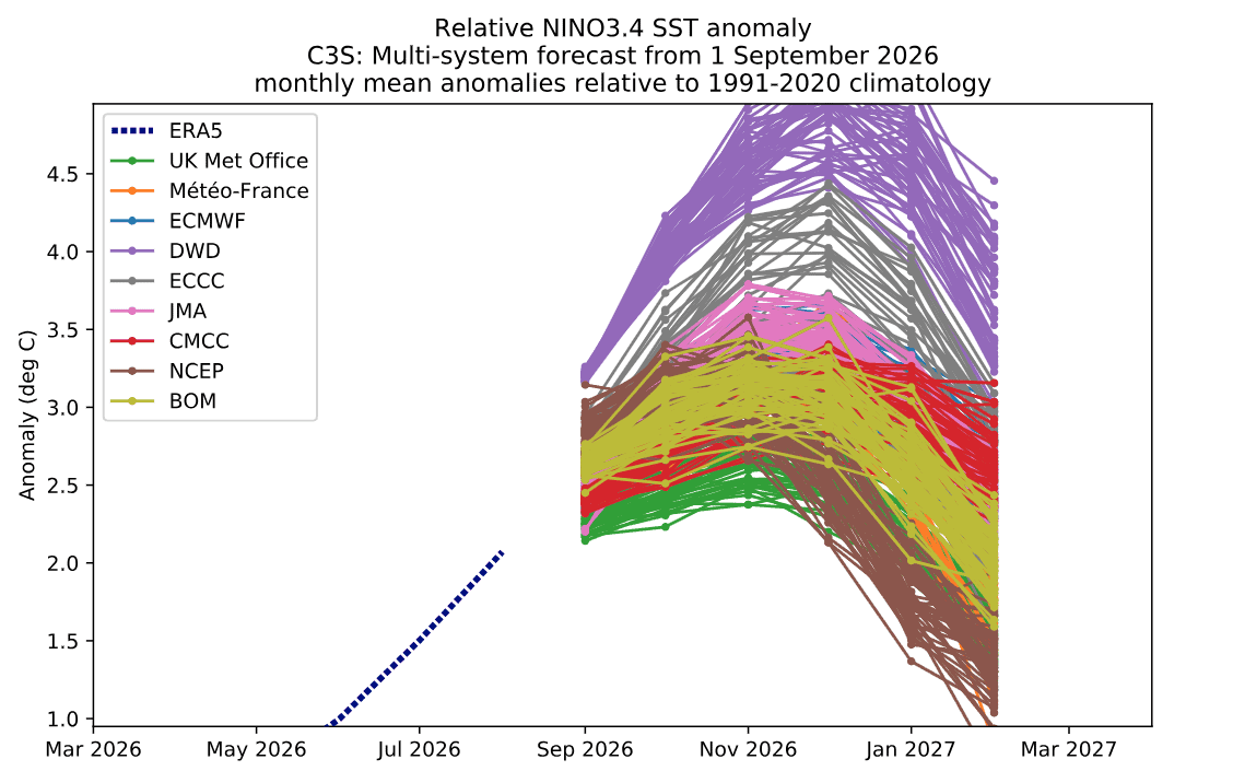
This brings me to the second figure, which shows more predictions of the future evolution of this curve through the winter. Broadly, we can see some pretty firm agreement that the peak will be early in the winter, around December on average. So, the short answer to whether it will persist is yes, but we may see conditions ease slightly coming into the back end of the season.
What does this mean for the Japanese snow season?
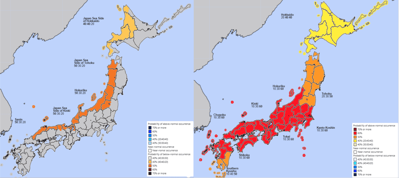
Let’s start with what the JMA is forecasting for this season and then work backwards as to why that is and what we are looking at. Starting with what we are all here for, below are the JMA outlooks for snowfall (left) and temperature (right) for the winter period (Dec–Feb).
Blues are the more ideal colour on this map, but the current outlook is for an average to below-average season in the Hokkaido region and a below-average to average season for Honshu areas. So, a slightly better outlook for Hokkaido, but an outlook leaning towards below rather than above average for other areas across Japan.
Moving next to temperature, we can see Hokkaido again faring best, with average to above-average temperatures. Moving further south through Honshu, the most likely outlook for temperatures gets slightly warmer.
Average to below average? Why?
Important question. Before we dive into the specifics, let’s do a quick idealised dynamics recap for the Japanese snow season.
ENSO is important for the snow season, but a more important driver of the snow season in Japan is the East Asian Winter Monsoon (EAWM). The nuance is that, because everything is connected, ENSO can have an impact on the strength and behaviour of the EAWM.
The EAWM is what drives the strong and, importantly, cold north-westerly winds that stream across the Sea of Japan in winter and bring boatloads of high-quality pow to the Japanese ski fields. One key driver of the strength of these north-westerlies is a semi-permanent high-pressure system across Siberia, which is aptly known as the Siberian High.
The basic way to think of it is that a stronger Siberian High leads to stronger EAWM winds and, in turn, usually a better-performing snow season with more heavy snow-bearing systems.
How does ENSO tie into this? Well, usually during an El Niño year, the strength of the Siberian High is weakened, which, as we just spoke about, can lead to less strong/frequent cool north-westerly winds across the Sea of Japan. One way this is done is by the promotion of an anomalously high-pressure pattern in the North Pacific.
Pressure Points
Looking at the outlook for pressure over the winter below, we notice anomalously lower pressures throughout the northern Asian region, signifying a slight weakening of the Siberian High. As we spoke about above, that can lead to less strong cold north-westerlies hitting Japan.
Also, for an idealised scenario, we would rather see lower-than-normal pressures in the North Pacific to promote these north-westerlies than the high seen below. Higher-than-normal pressure in this area can be associated with El Niño conditions.
One interesting thing to notice between these two plots is that, as we move into winter, the maximum areas of anomalies seem to decrease, suggesting a less pronounced impact through the second half of the winter.
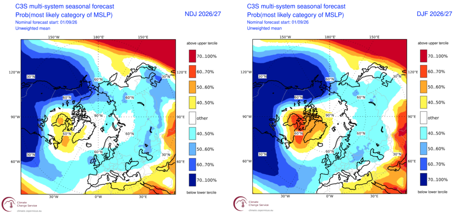
Three-month forecast for MSLP for the Northern Hemisphere for the Nov–Jan period (left) and the Dec–Feb period (right). Source: Copernicus Climate Change Service.
Precipitation Outlook
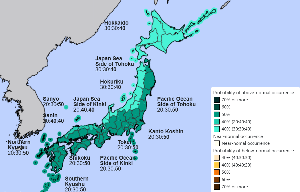
It sounds counterintuitive, but the JMA forecast for precipitation over the coming winter is actually above average. Make it make sense, Grasshopper.
Well, that anomalously high pressure in the North Pacific we have touched on lends itself to more onshore flow on the Pacific side of Japan rather than the Sea of Japan side. Linked to the reduction in the EAWM and warmer temperatures, these conditions typically lend themselves to average to above-average precipitation in winter, but particularly for the Pacific side. We can see this outlined in the outlook below.
Wrapping it up
So, for our initial look at the upcoming Japanese season, the most likely situation is an average to below-average snow season, favouring areas further north. Unfavourable pressure patterns and a potentially weaker EAWM may lead to warmer outbreaks and also promote more rain events. Northern areas may also be better equipped to naturally mitigate against this due to being colder in general.
Importantly, we need to remember that an average year in Japan still presents some of the deepest average snowfalls in the world, so don’t pack it in just yet.
I’ll keep my antennae tuned, with monthly updates heading into and through Japan’s season, so we stay up to date and my detailed weekly Japan forecasts will start in mid-December. Also, keep an eye out for my first North American outlook and how El Niño may impact snowfalls in the US and Canada – out soon.
– Grasshopper