Australian Forecast , Monday July 15th– Powder Alert! Heaps of Snow today & Some More in Next Couple of Days Too
Mountainwatch | The Grasshopper
We’ve been screaming out for it, and it’s finally here. A low-pressure system just southeast of us will deliver a hefty load of snow over to the Aussie Alps over the next few days, totalling between 15cm and 45cm.
The spread in accumulations is due to fluctuating snow levels, which cause some of it to fall as rain on mid and lower slopes from Tuesday onwards. However, the heaviest falls will occur later Monday into Monday night while the snow levels are nice and low.
Conditions will be rough most of the time with strong winds out of the west and south, but things will ease and mostly clear up on Thursday as the low moves away into the Tasman Sea.
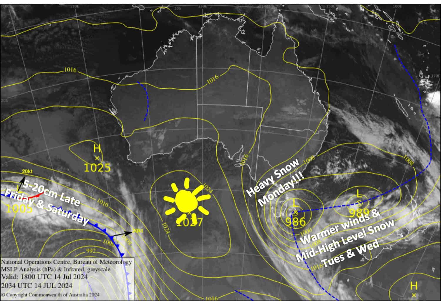 Latest pressure analysis and satellite image. Source: The BOM (vandalised by the Grasshopper)
Monday July 15th
Finally, a big snow day! Snowfall will build throughout the day, starting out light and then gradually becoming heavy from afternoon as westerly winds rise to gale force. It’ll get rough out there with blizzard conditions.
Warmer southerlies will spread over Victoria evening and night, lifting snow levels to around 1800m and turning snow to rain on mid-lower slopes. Fortunately, the precipitation will quickly ease once this happens.
Tuesday July 16th
Heavy snowfall over NSW will ease to showers during the morning as warmer southerlies arrive, lifting snow levels to around 1800-1900m.
In Victoria, rain and high-level snow will likely become heavy for a time from afternoon as snow levels, starting around 1700-1800m, lift even higher for a time. Strong southerly winds make for hearty conditions.
Wednesday July 17th
Periods of rain and drizzle falling as snow above about 1700m. However, Mt Buller won’t see much of it, and snow levels will lower in the evening before clearing at night. Strong southerly winds abating.
Thursday July 18th
SW winds will bring light snowfall to Baw Baw for much of the day with a few flurries possibly showing up on Buller along with some cloud. The other resorts will have a mainly fine, sunny day.
Extended Forecast
A front from the west is expected to bring a light-moderate load of powder as it passes over us late Friday into Saturday. At this stage, between 5cm and 20cm looks like a good bet, which will be a nice little bit of sugar on top of the cream.
From then on, we look to be on the cusp of storm activity over the Southern Ocean. Models disagree as to whether we’ll pick up just light snow showers early next week or something much more substantial. Forecasts later this week will give us a better indication.
That’s all from me today, folks. The next forecast is Wednesday. See you then, and have a great couple of days.
Grasshopper


