Grasshopper’s North America 2025-2026 Snow Season Outlook – La Niña Set to Send Snowfalls North

Mountainwatch | The Grasshopper
Welcome back to our North American Outlook series for the 2025/26 winter season and it’s off to an early start in some areas with decent snow totals already falling. Early snow falls are always welcome but let’s look into the crystal ball and see what we might expect for the season.
Current Conditions
Thanks to those storms, driven by deep lows in the North Pacific, there are currently a handful of Canadian and American resorts that have been able to open early. In the short term there is more snow on the way for most areas particularly throughout the Rockies and the Sierras which will help build and early season base. In the next 10 days the best totals are expected in Canada and the PNW, although temperatures may be borderline at times not surprising as it is only November.

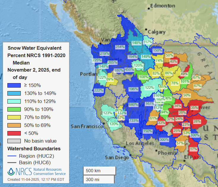
Below is a map of snow water equivalent (SWE) levels in basins across the western United States which shows their percentage of ‘normal’ (the median from the 1991-2020 period for that basin). We can see a solid beginning for areas further west and this map becomes more indicative of the snow performance further into winter. However, for now it gives us a hint about a solid start especially in the northwest, which is expected for reasons we will go through below.
Current Atmospheric Conditions
So, what’s the situation right now? Below we have the global SST (Sea Surface Temps_ anomaly, a usual feature of these outlooks, and the pattern in the Pacific Ocean is indicative of La Niña conditions. We have cooler than normal waters through the Central Eastern Equatorial Pacific and the Northeastern Pacific (blue ovals in the picture), warmer waters in the Western Equatorial Pacific and Northwestern Pacific (red ovals). So, it is no surprise you might have heard rumblings of a La Niña event this winter.

On La Nina Patrol
Right now, we are sitting in a ‘La Niña Watch’ with conditions currently in La Niñaterritory. As we have discussed with ENSO in previous years it depends on who you’re asking as to what the exact criteria for an event are. America’s National Oceanic and Atmospheric Administration (NOAA) has declared a La Niña advisory and conditions are expected to peak in the first half of winter (Dec-Jan) and gradually transition to neutral through the end of the winter season.
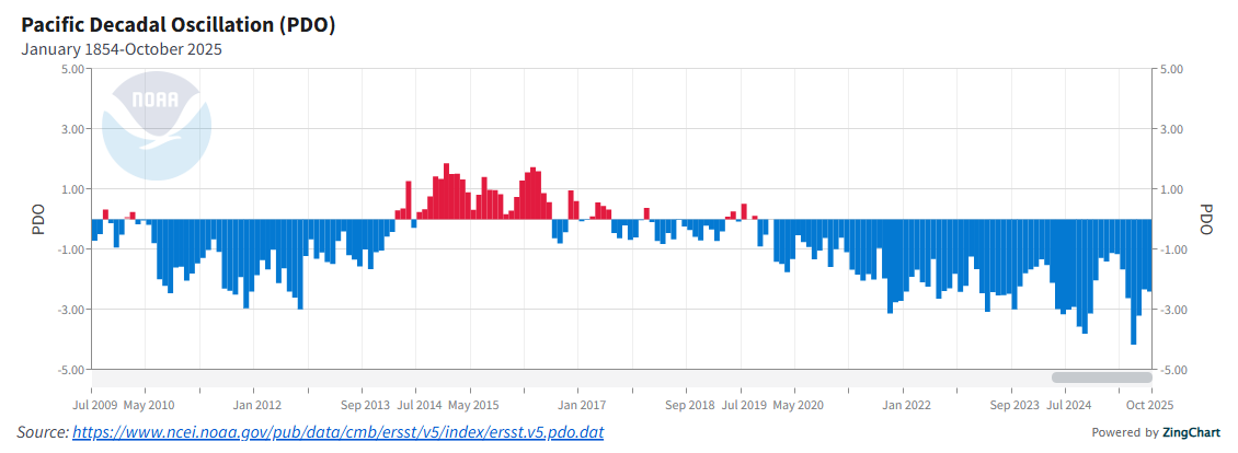
An interesting note during our Pacific focus is the state of the Pacific Decadal Oscillation (PDO). The PDO can be thought of as a longer-term state of the Pacific with variability on a more decadal than interannual. It is of use to us because during a negative PDO phase there is an increased tendency for La Niña events to occur and the PDO can amplify ENSO when the two are in phase (e.g. both positive or both negative). The graph below shows an index that tracks the PDO, we see a negative shift in the last five to eight years which most recently in July this year reached the most negative values ever recorded. This background negative Pacific signal can act to help reinforce the typical conditions of a La Niña, and those typical conditions are what we are going to investigate next.
La Nina Refresher
So, all this talk about ENSO what does it mean when zeroing in on North America? Below is a diagram from NOAA showing the typical changes induced by ENSO during the winter. Through changes in the typical pressure pattern in the North Pacific there are induced changes in the Jet Stream and hence typical storm track. I’ve included El Niño below so you can see the full picture but focus on the La Niña diagram (right) the storm track is shifted polewards/northwards and typically favours those areas in the northwest in terms of snow. The poleward shift also leads to cooler temperatures through more cold air bought down from the north.

Putting all the Pieces Together
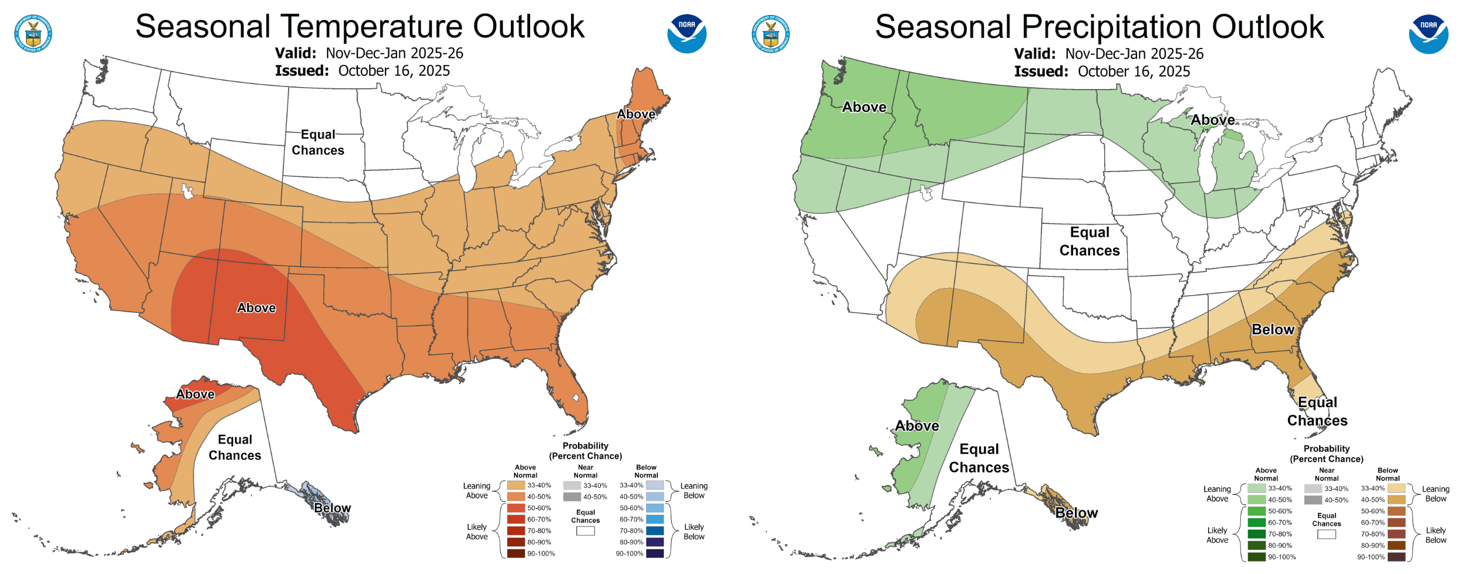
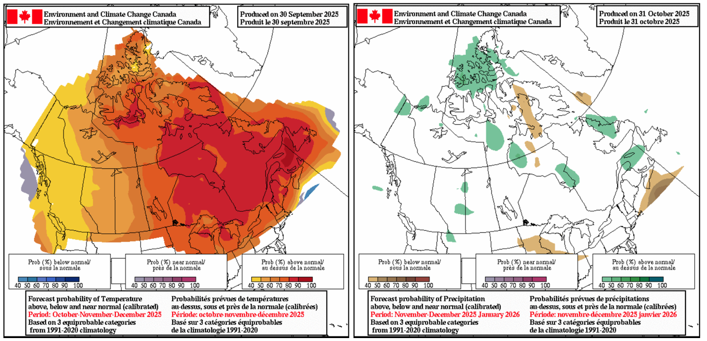
Now that we have had a little discussion about atmospheric dynamics let’s get to the point, where is looking the best and the worst? Below we have the NOAA seasonal forecast for the winter period in which we can see that La Niña pattern from above. Looking at the outlooks and after our own analysis the most favourable areas look to be north of and including Idaho/Wyoming, PNW, Canadian Rockies, Coast Mountains etc.
Throughout areas further south an underlying warmer than normal trend sees the chance of neutral influence for Utah/Colorado and for areas of California like Tahoe. Forecasted warming and small-scale variability are going to have an impact with similar years seeing some of those neutral areas like Tahoe/Utah perform quite well, but for now we will have to wait and see. Looking a bit further into the outlook it looks like slightly warmer temps than average will be expected initially. Overall, slightly above average temperatures for many US areas south of that Idaho/Wyoming line mentioned above.
Summing it up
A welcome start to many areas has seen some solid early season snowfalls with more in the way in the short term. Looking further ahead a La Niña event is expected to peak in the first half of the winter with conditions favouring areas of the northwestern US and the Canadian Coast Mountains/Rockies. Neutral conditions with perhaps slightly below average snow due to warmer temperatures and a northward shifted storm track are most likely for areas like Utah, Colorado and Tahoe. Short scale variability will come into play as we move into the thick of the season and I’ll keep you updated monthly throughout and stay tuned for my weekly North American forecasts, due to start in mid-December.
Get those skis/boards ready; it’s almost go time.


