Mountain Safety Collective Backcountry Conditions Report – Friday 5 September 2025

Mountainwatch |Mountain Safety Collective
The storm of the winter rounded out August with a bang late last week, delivering 60-80cm of cumulative snowfall that wind loaded more than a meter deep on leeward slopes. As the storm petered out through last Saturday, cold winds kept the surface snow dry, providing excellent quality turns for anyone braving the elements.
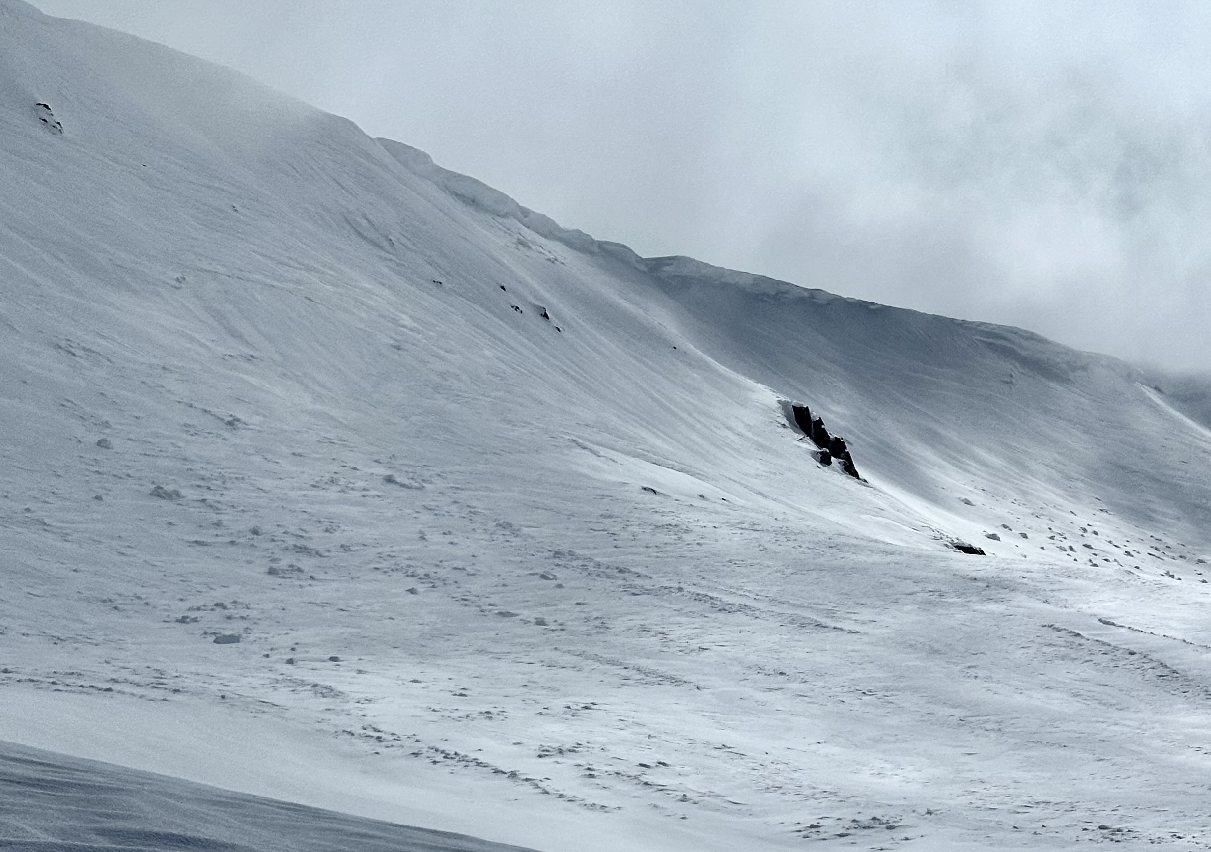
This new snow came with multiple reports of windslab avalanches along with evidence that an entire slope on Mt Kosciuszko released at some point during the storm, likely triggered by a cornice collapse. These observations reinforced MSC’s “Considerable” avalanche hazard rating we’d posted during and straight after the storm and our advice to step out cautiously.

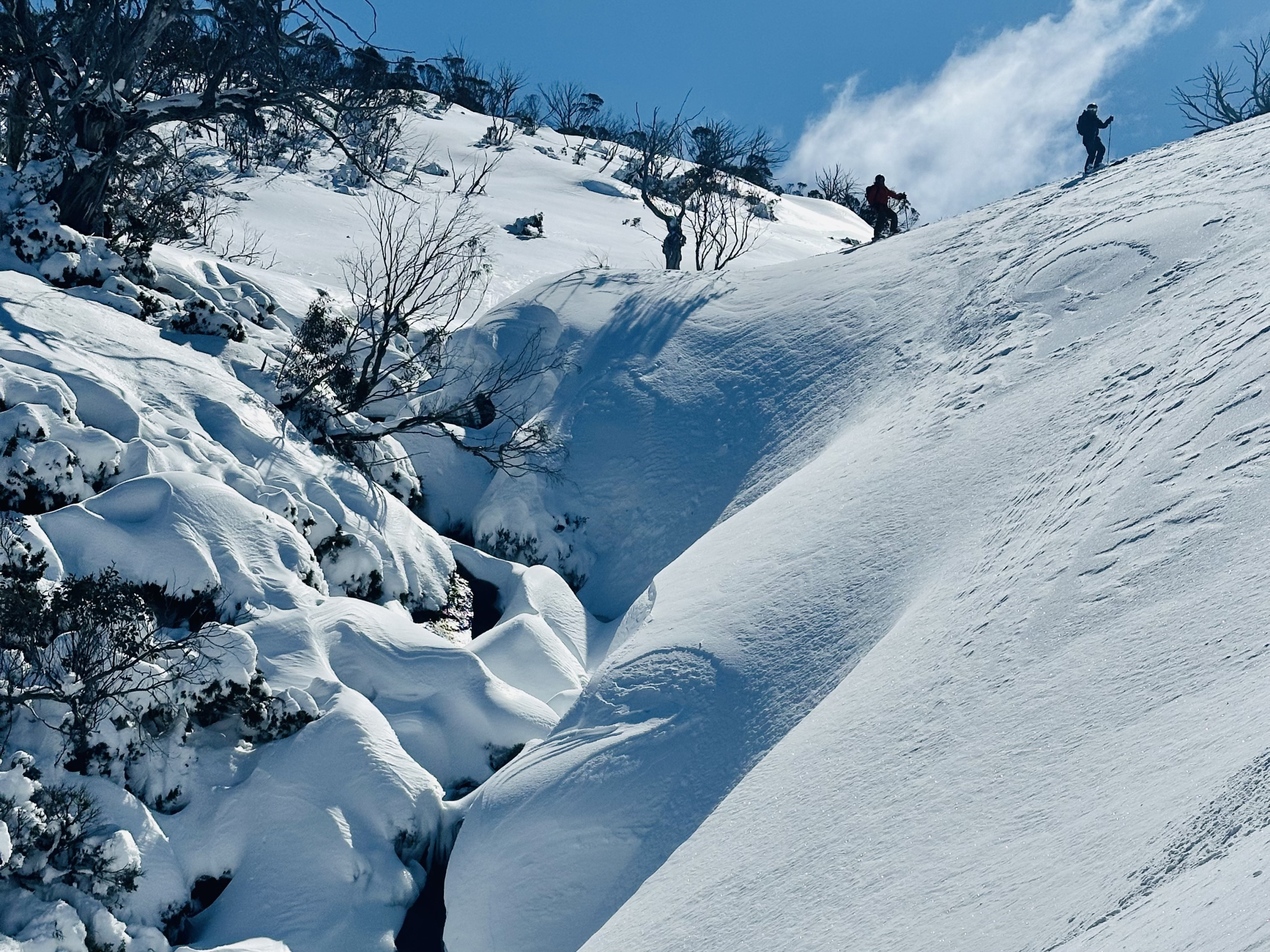
Sunday and Monday saw the sun return with phenomenal conditions on offer across the mountains. As temperatures climbed and the winds remained moderate, it was a case of seeking out sheltered slopes that were holding the best quality snow. Some ridgetops were stripped back to rime ice requiring crampons to exit, while alpine slopes became extensively windscoured by Tuesday morning, bringing the powder frenzy to n swift end.
The winds have been roaring throughout Wednesday and Thursday this week with snow falling above 1700m since Thursday morning. This should see 5-10cm of new snow by Friday morning, with much deeper wind loading on leeward slopes again.

As we move towards the weekend, Friday will be the pick with mostly sunny conditions, moderate winds and mild daytime temperatures. The sun will stick around on Saturday, but warmer north westerly winds will steadily increase through the day. Things turn for the worse on Sunday and Monday as extreme winds accompanied by mild temperatures and rain impacts the mountains. We’re unlikely to see clear weather again until late next week, so pay close attention to updated weather forecasts if you’re planning longer backcountry tours or snow camping missions after Saturday 6 September.
You can keep up to date with free Backcountry Conditions Reports every day by visiting Mountain Safety Collective.
Mountain Safety Collective Backcountry Conditions Report – Friday 29 August 2025
Last weekend saw the sun return to the mountains for a stunning run of clear days and exceptional quality spring corn snow on sun facing slopes. Monday saw temperatures climb significantly in the subalpine (10.4 degrees recorded at Perisher) after no overnight refreeze, resulting in an isothermal snowpack where the snow temperature reaches zero degrees and loses cohesiveness – i.e. slush!
Viv dropping off Ramshead on Monday morning with Kosci in the background.
Tuesday saw the wind pick up in the afternoon followed by a significant amount of prefrontal rain. Victoria saw under 30mm of rain, but NSW got smashed by over 100mm before temperatures fell enough for it to start snowing. This will have significantly depleted the snowpack at lower elevations with the rain impacting the slushy snow.
Thursday morning saw the core of the storm start impacting the mountains with around 25cm of fresh powder at daybreak and another 20cm by sunset. This “storm of the season” is set to continue until Saturday morning with cumulative snow totals in excess of 60cm. With the strong westerly winds, wind loaded snow will easily exceed a meter deep on leeward easterly slopes.
With such a significant storm, the message for the backcountry this weekend is to step things back and carefully assess the conditions before you rush into riding bigger terrain. The avalanche hazard will be significantly elevated due to the amount of windloading, so dial things back until it’s clearer what the snowpack stability is like.
Winds will remain elevated through Saturday but will abate on Sunday as the sun makes its return and a spring melt freeze cycle returns early next week. If you’re planning a snow camping adventure, the weather will remain relatively stable until stronger winds return on Wednesday and Thursday next week.
You can keep up to date with free Backcountry Conditions Reports every day by visiting Mountain Safety Collective and MSC’s Membership Drive closes on Sunday 31 August!
A big shout out to everyone attending the Australian Backcountry Festival in Hotham this weekend – this week’s storm will provide some epic conditions!
Mountain Safety Collective Backcountry Conditions Report – Friday 22 August 2025
If you were lucky enough to be in the backcountry early this week you’d know it was the highlight of an already great season so far. While Saturday’s storm snow totals barely nudged 10cm official depth, the wind loaded it up to 60cm deep on top of a supportive crust.
Stellar conditions across the Australian Alps earlier this week as this view from Ramshead to Mt Bogong in the distance attests!
This was followed by cold temperatures through Sunday that dipped to -12 at Thredbo top station on Monday morning, the coldest recorded temperature of the year. With no accompanying winds, these cold temperatures dried out the snow and provided the opportunity for some amazing footage from the backcountry.
The run of sunny weather continued until Wednesday afternoon in NSW before the edge of the coastal rain system brushed the mountains with a fine, wet mist that saturated the snow surface through Thursday. Victoria dodged the worst of the moisture but milder temperatures have been creating softer surface conditions there too.
Navigating through the moist fog in NSW on Thursday.
As we move into the weekend, high pressure will dominate the mountains with partly cloudy conditions on Friday into Saturday, clearing to mostly sunny on Sunday and Monday. Winds will remain light to moderate and we’ll likely see a melt freeze cycle develop from Sunday morning as nighttime temperatures dip below zero and solar aspects soften through the day. Overall, the next few days will provide a good opportunity for longer backcountry tours and snow camping.
A significant storm system will develop from Tuesday 26 August and run through the rest of next week, accompanied by extreme winds and blizzard conditions with forecast models starting to indicate 30-50cm of new snow.
You can keep up to date with free Backcountry Conditions Reports every day by visiting Mountain Safety Collective and MSC’s Membership Drive will be releasing a load of new prizes up for grabs in August!
Mountain Safety Collective Backcountry Conditions Report – Friday 15 August 2025
The past week saw the tail end of a long run of high pressure over the mountains creating a spring-like melt freeze cycle of cold clear nights and mild days with snow softening on sun facing slopes. The name of the game during these periods is to be aiming for the terrain you want to ski by late morning in time for the morning crust to release into soft corn snow.
Taking in the view from North Ramshead earlier this week
With morning ice comes an elevated sliding hazard, so carrying ski and splitboard crampons is often essential for early ascents whilst utilising self arrest tools like whippets or ice axes and maintaining caution on steep slopes should you slip and fall.
A weak trough crossed the mountains on Wednesday that delivered a few millimetres of precipitation, falling as snow in the high alpine. We then saw low cloud lock in against the NSW Main Range on Thursday creating white out conditions despite most weather forecasts expecting a blue bird day.
As we move into Friday, a cold front will bring increasing winds through Victoria early in the morning, with NSW being impacted from around lunchtime onwards. This system will bring snowfalls from late Friday night and throughout Saturday with most forecasts indicating flurries continuing until Monday resulting in 15-20cm of cumulative new snow. Winds are forecast to abate through Sunday while freezing levels could fall as low as 800m. This should provide a welcome top up, but venture out cautiously until there’s clarity on how well this new snow has bonded to the firm crust.
The sun should return by Tuesday with a run of clear days expected through the middle of next week providing potentially great conditions for longer backcountry missions after some fresh snow.
You can keep up to date with free Backcountry Conditions Reports every day by visiting Mountain Safety Collective and MSC’s Membership Drive will be releasing a load of new prizes up for grabs in August! If you’re in Mount Hotham on Friday 15 August, check out the Film Night.
Mountain Safety Collective Backcountry Conditions Report – Friday 8 August 2025
Last Sunday saw arguably the nicest day in the backcountry this season as a high pressure ridge cleared the mountains of cloud accompanied by the rarity of almost no wind, with sun facing slopes softening into spring-like corn snow by lunchtime. The sun continued on Monday morning, but the wind picked up through the day as a fast moving cold front approached on Monday night.
The view from Rawson Pass across the NSW Main Range on Sunday 3 August
Temperatures remained stubbornly mild into Tuesday morning accompanied by extreme winds over 100kph and the system delivered around 10mm of rain in NSW and 20mm in Victoria. Low cloud behind this front obscured visibility through Tuesday and into Wednesday making for unpleasant conditions.
With the sun returning on Thursday, it seemed like we were in for a repeat of Sunday’s spring-like conditions, but Tuesday’s rain had created a crust on all aspects and elevations up to 10cm thick that failed to soften through the day despite mild temperatures and bright sunshine.
As we move into Friday and the weekend, a large high pressure system will bring cold nights and clear days to the mountains making for ideal backcountry touring weather. The next cold front is forecast to arrive on Wednesday 13 August followed by a larger snow bearing system from 16 August.
However, with the widespread surface crust in place across the mountains, there’ll be an elevated sliding hazard, particularly in the mornings before any softening on sun facing slopes is possible. Carrying crampons will be a must and tools for self arrest if travelling on steeper terrain.
You can keep up to date with free Backcountry Conditions Reports every day by visiting Mountain Safety Collective and MSC’s Membership Drive will be releasing a load of new prizes up for grabs in August! If you’re in Hotham next week, check out the Film Night on Friday 15 August.
Mountain Safety Collective Backcountry Conditions Report – Friday 1 August 2025
The major weather event of the past week was the huge, continent-spanning low pressure system that moved across south east Australia from last Saturday to Tuesday. This system was pulling moist air from Indonesia, down the east coast and then back onto the mountains, resulting in moist snow above ~1800m and rain on lower slopes. Perisher recorded 109mm of precipitation and Mount Hotham 88mm during this period.
The good news is that what did fall as snow continued to build this season’s impressive alpine snowpack as westerly winds loaded snow onto the leeward (easterly) slopes. While the moist, dense snowpack is largely stable, large cornices have started to develop with the possibility they will collapse, so be extra cautious when travelling on top or below them.
Take care around large cornices that have developed over the past week.
Tuesday and Wednesday saw excellent quality skiing down to around 1700m while the alpine peaks were shrouded in low cloud and fog requiring white out navigation. With winds swinging to the east in the back half of the week, moisture impacted the snow surface and refroze in the colder temps on Thursday night, so be prepared for a crust on most aspects and carry crampons for safe uphill travel.
As we move into the weekend, the weather forecast is largely favourable for backcountry travel with light to moderate easterly winds before returning to stronger north westerly winds on Monday. Cloud is forecast to increase through Friday evening into Saturday with the chance of light snow flurries before clearing into a mostly sunny Sunday and Monday accompanied by milder temperatures.
You can keep up to date with free Backcountry Conditions Reports every day by visiting Mountain Safety Collective and MSC’s Membership Drive will be releasing a load of new prizes up for grabs in August!
—————
Mountain Safety Collective Backcountry Conditions Report – Friday 25 July 2025
Last weekend’s classic run of sunshine and great snow in the backcountry came to an abrupt end as extreme winds and rain ripped through the mountains on Tuesday. Given the depth of the snowpack and the firm crust on many aspects, the rain didn’t do much damage and was quickly topped up by fresh snow as the temperatures fell overnight into Wednesday morning.
This new snow has been wind loaded onto east aspects by the westerly winds and adhered well to the moist surface following Tuesday’s rain. More snow fell on Wednesday night and Thursday saw exceptional snow quality on leeward slopes from peaks to valley floors. While areas of ice crust remain on westerly aspects and ridgetops, the new snow has healed previously icy south aspects. Continue to carry crampons in case you do encounter icy slopes.
Friday will see a cold morning and mostly cloudy day with winds increasing through the afternoon as the next front arrives through Friday night. Pay very close attention to the weather and backcountry forecasts in coming days, as this storm cycle will see extreme winds, pre-frontal rain and blizzard conditions from Saturday through to at least next Tuesday. Put any big mission plans on pause until a stable weather window returns.
Visibility will be very limited in the alpine during the next week as low cloud is forecast to hug alpine peaks and will be prime conditions to get lost in a whiteout. Stick to terrain below the treeline during these periods for better visibility and more opportunities to identify navigation landmarks. Be very confident with your whiteout navigation skills if you do venture into the alpine during these periods.
With larger volumes of snow forecast in this next storm and extensive wind loading on leeward slopes, wind slab avalanche hazards are likely to increase. You can keep up to date with free Backcountry Conditions Reports every day by visiting Mountain Safety Collective.
The Arc’teryx Winter Film Tour continues its run in Canberra and Jindabyne next week if you want to watch some fantastic mountain movies, and don’t forget that MSC’s Membership Drive is running with over $6500 of prizes up for grabs in July!
Mountain Safety Collective Backcountry Conditions Report – Friday 18 July 2025
The weather and snow have yo-yoed over the past week as a series of fronts crossed the mountains bringing every variation of conditions imaginable. Last weekend saw a potential repeat of 2023’s great ice age as a humid mist covered the soft powder and froze into an impenetrable surface crust last Saturday. A light top up of snow last Sunday night then transformed east facing slopes into the day of the season (so far) on Monday morning with non-stop wind buffed powder laps. The rest of the week has then alternated between sunny days and complete white out conditions while the strong westerly winds have remained a constant factor.
Wind blown snow on east facing slopes is this weekend’s backcountry objective
As the sun rises on Friday morning, we’re back to blue bird sunshine with a generally clear forecast until Monday. If you’re planning any snow camping missions, factor in that extreme north westerly winds (above 60kph) are forecast to pick back up through Saturday afternoon when choosing a sheltered tent site. Winds will abate through Sunday before picking up again on Monday afternoon ahead of the next cold front and precipitation on Tuesday.
Snow conditions remain highly variable depending on aspect and elevation, with the best wind blown snow generally found on leeward (east facing) slopes below the tree line. There may also be a risk of small wind slab avalanches on wind loaded slopes, so take your time to assess conditions before dropping into any big lines. Windward (west facing) slopes and ridgetops have been largely stripped back to the ice crust, so carry crampons if you’re planning to access those areas and be conscious of the slide for life risk on steep exposed slopes. At lower elevations there’s likely to be some areas of breakable crust to carefully navigate on the descent.
Overall, the snowpack depth is now consistently covering most major hazards above 1600m and any top ups of additional snow will continue to improve backcountry conditions.
Mountain Safety Collective Backcountry Conditions Report – Friday 11 July 2025
This week saw the start of back to back snow bearing weather systems that should see consistent snowfalls well into late July. The double edged sword of Australian snow storms is that they’re usually accompanied by extreme winds which has seen extensive lifts on hold in the resorts since Tuesday and blizzard conditions in the alpine making backcountry trips not advisable at higher elevations.
The week started with rain to all elevations on Monday that created a widespread ice crust when temperatures dropped below freezing on Tuesday July 8. This was followed by snow above ~1700m on Wednesday that loaded into wind drifts of 40-50cm deep on lee aspects. A second, much colder front impacted the mountains on Thursday seeing snowfalls below 1000m elevation and excellent quality cold powder across NSW and Victoria with wind loading of 20-30cm on lee slopes by lunchtime above 1800m.
MSC’s early season Field Observer training was held this week in NSW & Victoria.
For those following along, this means we now have 60-80cm of windloaded snow on a widespread ice crust. While this was stubborn to react in snowpack stability tests MSC ran on Thursday, exercise caution on steep wind loaded slopes over the next few days, as wind slab avalanches with substantial volume may be possible.
When visibility is a whiteout in the alpine, stay below the tree line for a better view.
Winds will back off a bit on Friday but will still be in the moderate to strong range while temperatures become a bit milder, making the new snow heavier and denser. Visibility is likely to remain poor in the alpine, so stay below the treeline if you like being able to see. Be aware that the snowpack in the sub alpine is still relatively shallow with hazards like fallen trees still lurking and creeks flowing strongly.
A brief respite with light to moderate winds and sunny periods is expected on Saturday, so make the most of this before the wind and precipitation returns on Sunday. Pay very close attention to the weather forecast if planning any snowcamping.
You can keep up to date with free Backcountry Conditions Reports every day by visiting Mountain Safety Collective. We’ll also have MSC representatives at most of the east coast venues for the Arc’teryx Winter Film Tour if you want to watch some fantastic mountain movies.
Don’t forget that MSC’s Membership Drive is running with June’s winners just announced and over $6500 of prizes up for grabs in July!
Mountain Safety Collective Backcountry Conditions Report – Friday 4 July 2025
Skiing untracked dry powder for five days after a storm is pretty rare in Australia, but that’s what we had until Monday this week if you’d been following the MSC reports and seeking out south east facing slopes in the backcountry. That abruptly ended on Tuesday morning as the edge of the east coast low brushed the mountains with low cloud, mild temperatures and liquid precipitation on lower slopes.
Matt Nethery navigating this week’s whiteout by skinning downhill.
The mountains were spared the worst of east coast low, with the Perisher weather station recording 36mm in 48hrs and Victoria only a couple of millimetres with moist snow falling above 1800m. Combined with above freezing temperatures and strong winds the snowpack on slopes below 1800m will have contracted, exposing rocks and bushes with creeks flowing swiftly.
With clear skies returning, an overnight refreeze into Friday morning will see widespread surface crust before temperatures warm and the snow surface softens in the sun through the day. This pattern will continue into Saturday before a low pressure trough crosses the mountains in the evening bringing stronger winds and some precipitation into Sunday.
If you’re planning a backcountry tour this weekend, Friday and Saturday will be the pick in terms of weather with the best potential for rideable snow in the higher alpine, but adopt a cautious mindset until you’ve been able to assess the conditions in person. If planning snow camping adventures, choose sheltered sites from the forecast strong north/north westerly winds on Saturday night.
Things get a lot more exciting next week as a significant storm system impacts the mountains from Tuesday until at least Thursday accompanied by extreme wind speeds and snow totals of 40-60cm.
You can keep up to date with free Backcountry Conditions Reports every day by visiting Mountain Safety Collective. We’ll also have MSC representatives at most of the east coast venues for the Arc’teryx Winter Film Tour if you want to watch some fantastic mountain movies.
Don’t forget that MSC’s Membership Drive is running with June’s winners just announced and over $6500 of prizes up for grabs in July!
Mountain Safety Collective Backcountry Conditions Report – Friday 27 June 2025
This week has seen every side of what the weather can do in the Australian mountains. The wind picked up on Monday morning with gusts exceeding 100kph and 70-90mm of rain fell through the night before temperatures dropped below zero and it turned to snow by mid morning. We then saw extreme blizzard conditions into Wednesday with wind gusts peaking at 122kph and wind chill of -23 degrees recorded at Thredbo top station. By the time the storm cleared on Wednesday evening most resorts were reporting 30-40cm of fresh snow.
The view of Mount Kosciuszko on Thursday morning
Thursday saw a stunning cold blue bird day and MSC’s field teams were able to get out for observations and found the wind was the main factor in where this new snow has ended up and what its quality is like to ski and ride. The broad story is that the rain has consolidated the deeper snowpack from the June long weekend storm and a rime ice crust has formed in places where this older layer is still exposed. Windward slopes to the West and South and ridgetops have been heavily scoured by the wind and leeward slopes to the East and North have been loaded with snow, with depths of up to 275cm recorded in high alpine wind drifts. Snow in the alpine is densely windpacked and scoured into sastrugi ridges. Below the treeline, the surface snow is generally softer but the snowpack is still much thinner and exposed hazards remain, like open creeks, rocks and partially buried timber.
You can keep up to date with free Backcountry Conditions Reports every day by visiting Mountain Safety Collective. We’ll also have MSC representatives at most of the east coast venues for the Arc’teryx Winter Film Tour if you want to watch some fantastic mountain movies.
Don’t forget that MSC’s Membership Drive is running with June’s winners just announced and over $6500 of prizes up for grabs in July!
A skier-triggered wind slab avalanche photographed from the Blue Cow Ridge Chair on Thursday morning.
The main hazard to be aware of after a storm event like this is the potential for wind slab avalanches on lee slopes. This became very apparent when a skier ducked the rope into the closed zone of Rock Gardens at Blue Cow on Thursday morning and triggered a larger avalanche into a terrain trap chute. While there were no reports of injuries it highlighted the risks even within resort boundaries.
The next few days across the weekend will see stunning weather conditions with clear skies, colder night time temperatures and light winds, so perfect for snow camping and bigger objectives. Be aware that daytime warming on sun exposed slopes may create instability. Cloud returns on Monday with some unsettled weather from Tuesday into Wednesday.
You can keep up to date with free Backcountry Conditions Reports every day by visiting Mountain Safety Collective.
Don’t forget that MSC’s Membership Drive is running with some fantastic prizes to be drawn at the end of June and more in July and August.
Mountain Safety Collective Backcountry Conditions Report – Friday 20 June 2025
Welcome back to MSC’s weekly backcountry conditions summary that we’ll be publishing on Mountainwatch exclusively every Friday.
We had a fantastic start to the season on the June long weekend with around 60cm of snow across NSW and Victoria to start setting things up. If you’ve visited the daily Backcountry Conditions Report, you’ll see we’ve been using the term “Early Season” frequently. This period is characterised by a snowpack that’s variable in terms of depth and surface quality and hasn’t completely covered obstacles like rocks, creeks, fallen trees and bushes yet. As such, it’s important to be stepping out cautiously and assessing conditions as you go.
MSC Field Observer Art Hodder inspecting the debris from a larger wind slab avalanche that a skier triggered (without injury) on Wednesday 18 June.
It’s important to note that the first large snowfall has been followed by consistently cold temperatures over the past two weeks, meaning that the snow has stayed relatively dry and unconsolidated. This has meant that lower altitude approaches have been very unsupportive with lots of collapsing through to bushes. On popular touring trails, this is mitigated by staying on established skin tracks that have compressed the snow down and provide more stability.
Daytime temperature fluctuations have also seen a widespread breakable crust form on the snow surface up to around 1900m which has made skiing back down through the trees particularly difficult. You may need to carry ski crampons for early morning ascents.
It’s a better story in the higher alpine above 1900m, where strong winds have packed the snow into a more supportive state and extensive pockets of windblown snow have provided great skiing this week. Be aware that this windblown snow has created windslabs on lee (Easterly) slopes. The avalanche pictured above on Mount Tywnam is an example of this where windblown snow has accumulated on a harder bed surface and released when a skier with the appropriate skills intentionally tested it before skiing the slope.
The weather forecast for the weekend ahead is superb, with clear skies, warm days and light winds. Make the most of this before we see prefrontal rain on Monday ahead of some new snow through the middle of the week.
If you’re in the mountains already, join MSC for the Alpine Education Series in Jindabyne and Bright over the next couple of weeks. MSC’s Membership Drive is also running with some fantastic prizes on offer.
You can keep up to date with free Backcountry Conditions rReports every day by visiting Mountain Safety Collective.