New Zealand Weekend Forecast, Friday September 19th – Friday & Saturday the Picks with Fresh Snow & Sunshine
Mountainwatch | The Grasshopper
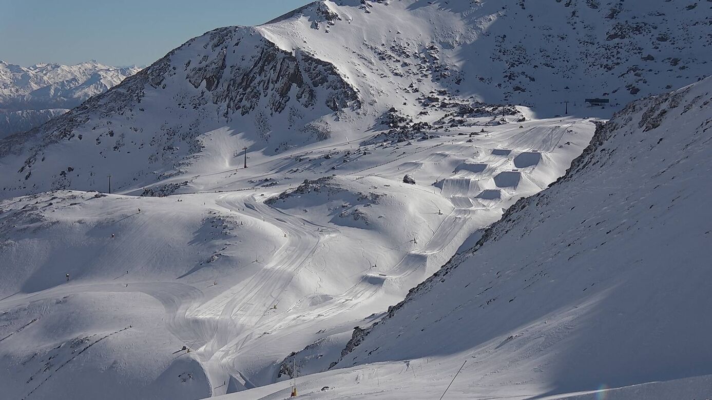
After a thorough drenching and ferocious winds on Wednesday. Temps thankfully dropped, leaving a nice 10-20cm new layer of powder over the Southern Lakes by Thursday morning and a dusting on some ski fields in Canterbury. A cold southerly whipping up the country has dropped more snow since late Thursday. Morning reports will have the latest number on this, but we were expecting a dusting for the Southern Lakes and a more substantial top-up for Canterbury, while Mt Ruapehu will receive a wee top-up throughout Friday.
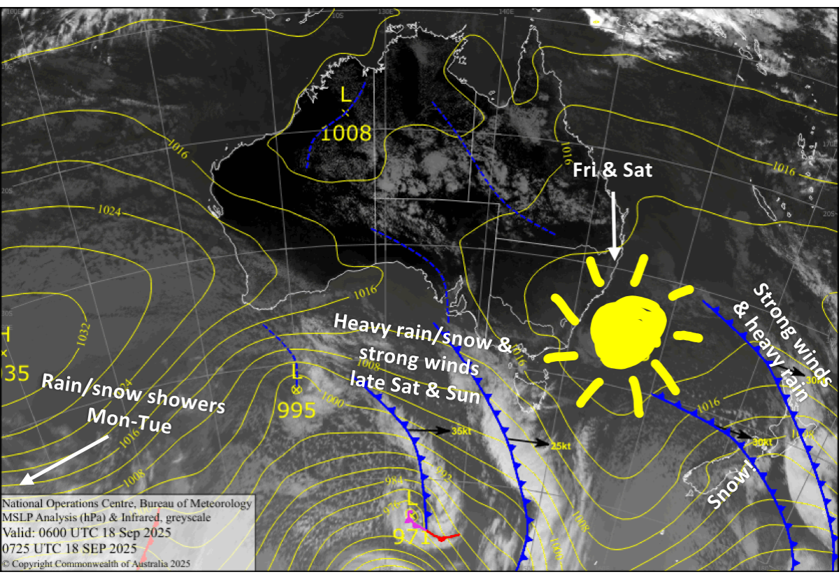
A lovely, sunny ridge moves up the South Island on Friday and the North Island on Saturday, these being the picks of the bunch.
Conditions will deteriorate again as a strong front moves up the South Island from late Saturday, with heavy snowfall expected up high. The front stalls over the upper South Island later on Sunday, and then another front from the south gives the upper slopes of the Southern Lakes a dusting of snow on Monday.
Then, on Tuesday, the front stalled over the upper South Island could sink back south over Canterbury, bringing a mix of rain and snow. However, confidence in this is low, so it’s subject to change.
Friday September 19th
Any remaining snowfall and cloud clear South Island ski fields early as a ridge of high pressure moves up the country, leaving a fresh layer of powder and sunny skies. Northwest breezes develop, and there’ll be some afternoon high cloud over the Southern Lakes.
A cold southerly whips over Mt Ruapehu early morning, bringing snow showers to low levels. The snow showers clear later in the afternoon as the winds ease, leaving an extra 5-10cm of fresh powder.
Saturday September 20th
Cloud builds and northwest winds strengthen over the South Island as the next front approaches. Later in the afternoon, the winds will reach severe gale in exposed areas, so expect left operations to be affected. The front moves up the South Island after dark, bringing heavy rain and dense mid- to upper-level snow.
The ridge passes over the North Island with sunny skies for Mt Ruapehu, while easterly breezes turn northwards.
Sunday September 21st
The heavy rain and mid- to upper-level snow clears the Southern Lakes early and then Canterbury later in the afternoon as the front continues northwards before stalling over the upper South Island. This leaves mainly sunny skies and deep, dense snow about the upper slopes. Severe gale northwesters also back off behind the front, but this won’t happen till late in Canterbury, where ski fields will either be closed or have limited operations.
Strong northerly winds will bring overcast skies to Mt Ruapehu.
Monday September 22nd
Partly cloudy for the Southern Lakes. Showers of rain and high-level snow spilling over the Main Divide from a front from the south will likely reach ski fields there in the afternoon and evening, giving the upper slopes a dusting. Northwest winds will be strong in exposed areas of the South Island, so although Canterbury will be sunny, lift operations could be hampered.
Brisk northerlies again for Mt Ruapehu with plenty of cloud and a bit of light rain and drizzle.
Tuesday September 23rd
The front stalled over the upper South Island sinks back south, spreading a mix of rain and snow and northerly winds down over northern and central parts of Canterbury. A few light showers of rain and mid- to upper-level snow may also reach the Mackenzie Basin and Southern Lakes, where skies will otherwise be cloudy along with light northwest-to-northeast breezes.
Another cloudy day for Mt Ruapehu with light rain and drizzle at times as brisk northerly winds persist.
Extended Forecast
A wet and warm storm system rolls over the upper South Island and North Island on Wednesday, September 24th, which will pave the way for strong, stormy winds from the westerly quarter to establish over the country.
The winds may last through to the end of the month and possibly into the start of October. A steady supply of fronts embedded in the flow will bring frequent shots of powder, although we could see substantial rainfall next weekend, the 27th and 28th September, ahead of one such front. The snowpack could grow substantially, but strong winds will likely play havoc on the snowpack and lift operations.
That’s all from me today, folks. I’m sending out these forecasts every Monday, Wednesday and Friday throughout the season. Have a great weekend, and I’ll see you back here on Monday.
Grasshopper


