North America Forecast – The Big Calm, followed by big snowfalls in the Sierras
Mountainwatch | The Grasshopper
Wednesday 9thof January (Pacific time)
The ten-day snow accumulation chart paints a rather different picture this week with the southern half of North America inline to score the bonanza, while the northern half clocks up some sunshine hours during the “Big Calm”. The Sierras sticks out like a sore toe with figures reaching over 2m at the extreme end and around the 1m mark at the lower end. Most of this will fall from Monday onwards as storms in the Pacific take aim there. The southern half of the Rockies too will score anywhere between 30-60cm from these more southern placed storms.
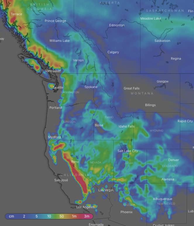
The Sierras stick out like a sore toe in this week’s ten-day snow accumulation chart. Source: windy.com
Thursday 10 Jan:
A big low churning in the Pacific will push northerly winds and snow onto the Coast Mountains of Canada, some which will cop the northern Cascades early in the day. Remaining snowfalls over the northern half of the Rockies from the previous days leftovers will mostly clear, but a low over the High Plains will spark up light to moderate snowfalls over the southern portion later in the day.
Friday 11 Jan:
The low off the Pacific Coast will shoot north, sending its southern extending front over the Sierras at night, providing a nice wee dusting there. Before then, snowfalls would have cleared the Coast Mountains early in the day, as well as Wyoming and New Mexico, but they will linger over Colorado until late.
Saturday 12 Jan:
The last of the dusting will clear the Sierras early and we might see snow flurries about the Coast Mountains for a time. Apart from that, the western half of North America will be rather snowless and settled under high pressure, while further east will be getting a fair dolloping.
Sunday13 Jan:
The Big Calm continues with high pressure still dominating the scene. However, the Sierras will break the silence with light snowfalls getting going there during the second half of the day, thanks to a low migrating southwards off the Pacific Coast.
Monday 14 Jan:
We may have light to moderate snowfalls again over the Sierras as the low stops its southward trajectory and inches closer to the coastline. Models are iffy about these snowfalls throughout the day, but they tend to agree that there’ll be heavy falls at night/overnight, so it’s one to keep an eye on. Light snowfalls will also creep inland across Utah and into Colorado by the end of the day. Meanwhile, further north should remain mostly calm and clear.
Tuesday 15 Jan:
Snow should continue to come down over the Sierras with potentially heavy falls on the cards. Snow showers will make it onto the southern half of the American Rockies and the odd one may spring up further north later in the day as moisture finds its way to these parts.
Wednesday 16 Jan:
We should have yet more snow in the Sierras with potentially heavy falls as another low in the Pacific keeps things going there. The southern half of the American Rockies will also keep receiving light to moderate snowfalls, while models are undecided whether some of that will make it further north.
Extended Outlook:
Models tend to agree that snowfalls will eventually ease over the Sierras during next Thursday, while it may continue to come down over the Rockies through into next Friday. After that, another storm in the Pacific is lining up the Coast Mountains, Cascades and Sierras late next Friday or Saturday, with snowfalls likely to spread further inland to the Rockies thereafter.