SEASON OUTLOOK 2012 – September, It’s a Long Way Down
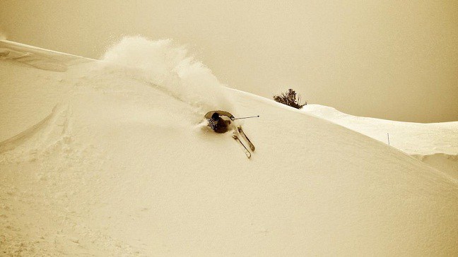
August has delivered quite a few days like this, slashing some in Falls Creek Image:: Hocking/Falls Creek
Season Outlook | The Grasshopper
Brought to you by ESS Boardstores
One month to go in season 2012 and already it’s obvious this has been one of the best years in recent memory. If June was like the first date, and July was a bit of foreplay, then you’d have to say that August has been one spectacular climax to a beautiful relationship. We’ve been loving the snow conditions with everything we’ve got and the snow has been loving us back.
Totals for August have been so good I’ve lost track of how much has fallen, and we’ve seen an absolute frenzy every weekend to get to the Alps and participate in an orgy of powder.
Sing when you’re winning
Leaving the tawdry connotations to one side for a second let’s have a look at how the seasonal outlooks have gone so far this winter and then cast forward to what we can expect from September. There were several big calls made that I’m really proud to recap and we can see them playing out in the Spencers Creek snow-depth graph for this season.
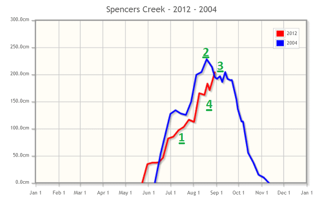
1) Back in May and June I was confident of a slow steady increase in snow-depths as we got popped with frequent small fronts. You can see this gradual build-up next to the number 1 below.
2) In May I pointed out that this year was looking similar to 2004, the last year we broke the two metre mark at Spencers.
3) In May I called a peak depth of 201cm, and I stuck to my guns through June and July even though the snow build up was only gradual. Spencers Creek hit 204cm on August 30.
4) In my July update I had a strong feeling we could see something special from August. I called several small fronts and one big storm from mid-to-late April. Well it turns out we’ve had three big storms and a couple of medium sized ones, and you can see that snow depth charging upwards next to the number 4.
So whether you call it skill, dumb luck, or a bit of both, I’m calling this a win for 2012.
Running at the cliff
Tomorrow is the start of spring and so my job today is to pick when those snow depths will slump away. September traditionally sees plenty of fronts crossing the Alps in a strong westerly flow so rainfall is fairly reliable. I covered some of the stats on this in an article last year
But this year is a little different because we’ve got an emerging El Nino event in the Pacific. That’s leading to higher pressures over the north of Australia that could keep passing fronts a little further south than normal. In addition to this, sea surface temperatures to the north-west of Australia are a touch colder than average, meaning the air up that way is cooler and drier. This can reduce the supply of moisture flowing down across Australia ahead of passing fronts and reduce rainfall across the Alps.
Taking into account all of the above, I would expect September to be a touch drier than normal for the resorts.
The wicked wind of the north-west
Those higher pressures and low rainfall will have another undesired effect, encouraging the formation of warm air masses over the interior of Australia. Even if September’s fronts don’t quite have as much rainfall as normal, we can still expect them to be preceded by a strong north-westerly flow that drags warm air down across the south-east. Then we get that dreaded hair drier effect that can drastically eat away at the snowpack.
With daylight hours getting longer we’re already seeing the development of warmer air masses over the interior of Australia. There are strong signs that some of that air will pay us a visit next Wednesday or Thursday with the freezing level reaching above 3000m. There are also hints of a similar pattern a week later. Although both systems could lay down some snow, my instinct is that we’ll lose more depth to rain and warm winds than we gain in fresh.
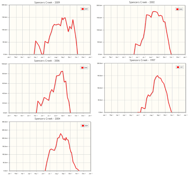
We can look back on some previous El Ninos to get a feel for this. Check out the graphs below for the five most recent El Nino flavoured Septembers and the dominant theme seems to be a loss of about 50cm of snow over the month. But apart from 2006, which was a rubbish year all round, snow depths were still generally over one metre by the end of September.
The big advantage we’ve got this year is that we’re starting from a nice high base, so we can easily handle losing 50cm, even 70cm, at the major resorts over the next month. The grooming teams are so good at working their magic during low snow years that my guess is they’ll have no trouble keeping us riding until the end of the season.
This is the Grasshopper’s last seasonal outlook for Australia this year. If you’ve enjoyed reading them and haven’t done already then please “like” my facebook page so I can let you know about the first outlook when we start up again next season. And if you’ve got questions, feedback, or a bone to pick please leave a posting or hit me up at grasshoppermw@gmail.com.


