Snow Season Outlook 2017 – June Update – Steady as She Goes
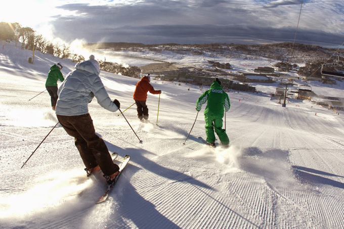
Not since 2012 have we had an early opening at Perisher, this Saturday – that’s all about to change. Image:: Provided
Australian Seasonal Snow Outlook – June update | The Grasshopper
Temperatures have been above average this Autumn but Ullr has finally worked some magic and things have started to take on a wintry feel. Images of an early snowy wonderland have been plastered all over social media. Perisher is even breaking with tradition to open early this weekend, and Mt. Buller is doing the same this Friday night, but be warned as it is still early days. Will this early snow last the test of time? More importantly, when will we get our first big ‘game-changing’ snow storm? I know that for some, these questions can be anxiety inducing. What with constant forecast checking and NWPs (Numerical Weather Prediction Models) moodier than Nicole Kidman on a good day it can all get a bit too much. There are times when it seems like getting a 30cm+ snowfall is about as likely as the Wallabies winning the Rugby World Cup. However, do not panic. Your friendly grasshopper is also here to impart some wisdom about how to live a zen life and to take the rainy days with the pow-loaded days.
In this outlook I am going to throw a number of ingredients into the wok to pull together various ideas about this upcoming season:
- First of all… it’d be good to blow away the cobwebs and have a re-cap on the first couple of seasonal outlooks this year.
- We will then have a chat about how things have changed in the last few weeks.
- This is the most exciting part of the outlook – I talk about what the weather is likely to be in the next couple of weeks. Can we score big in June?
- Finally, I will update the seasonal peak snowfall depth prediction.
Hit playback
In the first couple of outlooks of the season I outlined how we have a moderate chance of an El Nino developing this winter. El Nino (aka the biggest fluctuation in the Earth’s climate system) is characterised by a pool of warmer than average water lying in the central and eastern equatorial Pacific. For Australia, this means that if we get lumbered with a ‘classic’ flavoured El Nino then sumo-sized high-pressure systems park their fat arse over the Aussie Alps scuppering our chances for snow. This year, it looked like the Nino would go hand in hand with a positive Indian Dipole (IOD). In its positive phase IOD represents an increase in sea surface temperatures (SSTs) in the Western Indian Ocean. This has the knock-on effect of reducing precipitation in Australia. These factors led me to hypothesise that this season would be slightly worse than average for Australia – especially taking into consideration the long-term downward trend in peak snow cover exacerbated by man-made climate change.
Touch and go Nino
The climate models are notoriously unreliable at making predictions during Autumn and especially so when the ENSO (El Nino Southern Oscillation) state is transitioning. Measurements of sea surface temperatures have shown a warming trend in the Eastern Pacific during the last few months but it has not been enough to cross El Nino thresholds. *The main change to have taken place during the last few weeks is that the Bureau’s climate model has backed off the idea of an El Nino developing this winter.*The international climate models have also slightly shied away from the idea with roughly half favouring El Nino conditions developing towards the end of winter – any El Nino that does develop is likely to be weak. On the surface, this slight delay in El Nino conditions developing (if they develop at all) could be good news for our winter. Neutral years register on average 20cm more snow than either La Nina or El Nino years. However, hold your horses for now matey, the IOD is still forecast to remain positive though the winter. This would have the effect of reducing rainfall overall.
I’ve talked before about the SAM index (Southern Annualar Mode) and its effects on our snowfall. During a positive phase, the band of westerly winds encircling the Antarctic contracts while during a negative phase we may expect a higher proportion of low pressure systems getting closer to the Aussie Alps topping up our snow depths on a regular basis. The SAM index is generally persistent over a few months and has just turned positive after a long negative phase. Abnormally warm SST anomalies over SE Australia continue to persist and climate models forecast the warmer water to hang around through the whole winter. Higher than average SSTs over SE Australia are bad news for snow cover in the Aussie Alps.
Weather up Until Opening Day
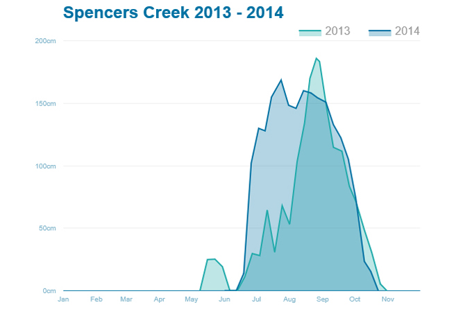
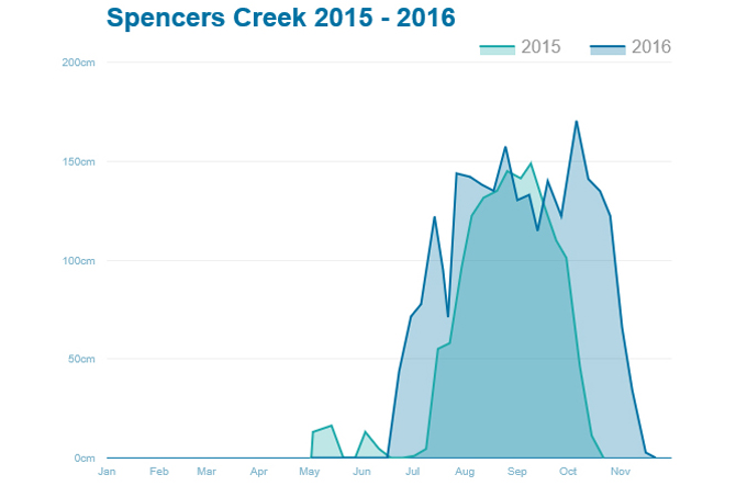
It is normal to have low snow depths at the start of the season, just look at the last four years. Source:: Snowy Hydro
Here in the Aussie Alps the season normally gets going late June/early July, a couple of weeks to a month after opening day. It is relatively normal to have no-snow or to just scrape through for the first couple of weeks of the season so don’t have a Facebook strop if you are not making snow angels on the 10th of June! The last four years confirm this hard-to-swallow fact. Little to no natural snow for the start of the season was followed by a sharp increase around the middle/end of the month in the case of 2014 and 2016. The neutral ENSO year of 2013 was a bit slower off the starting blocks but made up for it with a cracking August. One big snow storm can change everything and that’s why we love the Aussie season.
The numerical weather prediction models show that things will be pretty settled for the first week of June with high pressure firmly in control. This means mostly sunny days with daytime temperatures above freezing and cold nights which will be great for snowmaking. We will lose most of last weeks natural snow during this time so don’t be surprised to see bare patches on either side of the snow-gun maintained slopes. Things get interesting around the 6th of June. A cut-off low pushing up from the south-west could potentially deliver colder air and another dose of natural snow before opening weekend on the 10th. There is still a lot of uncertainty with the track of the low with the models flip-flopping around as to its location. Depending on the location of the snow we will get either rain or snow or a mixture of both! If we get lucky and it sticks to the south we could see 15-30cm of snow, a more northerly track could give us some nasty r–n followed by a rain/snow mix which would be a bit of a bummer I’m not going to lie. We will have to wait and see how this one develops in the next few days. A calmer period will develop on opening weekend itself as a high builds in from the west. The models then suggest another push of snow from the south-west around mid-month. Not bad for June!
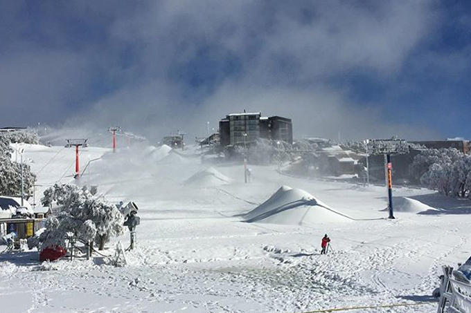
Buller has been stockpiling snow for weeks now thanks to their new snow factory system, announcing they’ll open this Friday night – and it’s free!. Source:: Provided
Summary
The recent snowfall and forecasts of further snow do not change the fact that overall this season is likely to be less snowy than average due to the positive IOD and the chance of El Nino conditions developing as the winter progresses. The SSTs are still warm in the Tasman. I am going to stick to the peak snow depth of 160cm that I forecast in the first outlook of the season. However, don’t get down about it as I still expect a few big storms to roll through. For now, we need to get as much cover as possible to last through the lazy high-pressure systems which will have you reaching for your sunscreen. We love the Aussie season with its characteristic highs and lows – and I’m not just talking about the weather systems. Technically there is no good or bad weather, what really matters is how we perceive it. So, this is a rallying call to all fair-weather skiers. Go snowboarding in the drizzle. Get up at 6am to make the first few turns after a fresh dump of snow. Experience the exhilaration of the first lift to watch the sunrise over the clouds during a settled period of high pressure. Accept that what you cannot change and make the most of what we can. Be wary of hashtags and promises of 60cm of snow. Give thanks to modern technology and the snow guns which give nature a helping hand where needed. I for one hope to see you up on the slopes soon to put in the first few turns of the season. Make sure you go skiing/boarding as much as possible this year – don’t Snapchat your way through life, ride through it!
That’s all from the Grasshopper. We’ll update this outlook in early July. If you’ve got a different theory on what’s going to happen this winter, or just want to provide feedback, then please hit me up on the discussion below. Or you can follow me on facebook. You can also subscribe to my Weekend Forecast e-mail which gives you the first heads up on any big dumps heading our way over the next few months.


