The Grasshopper’s Japan 2025-2026 Seasonal Outlook – La Niña Set to Deliver Above Average Snowfall
Mountainwatch |The Grasshopper
Welcome back new and regular guests to our Japanese Seasonal Outlooks. With the weather in the southern hemisphere getting warmer and the northern hemisphere getting cooler it’s time to look ahead to see what’s in store for us in only a couple of months’ time.
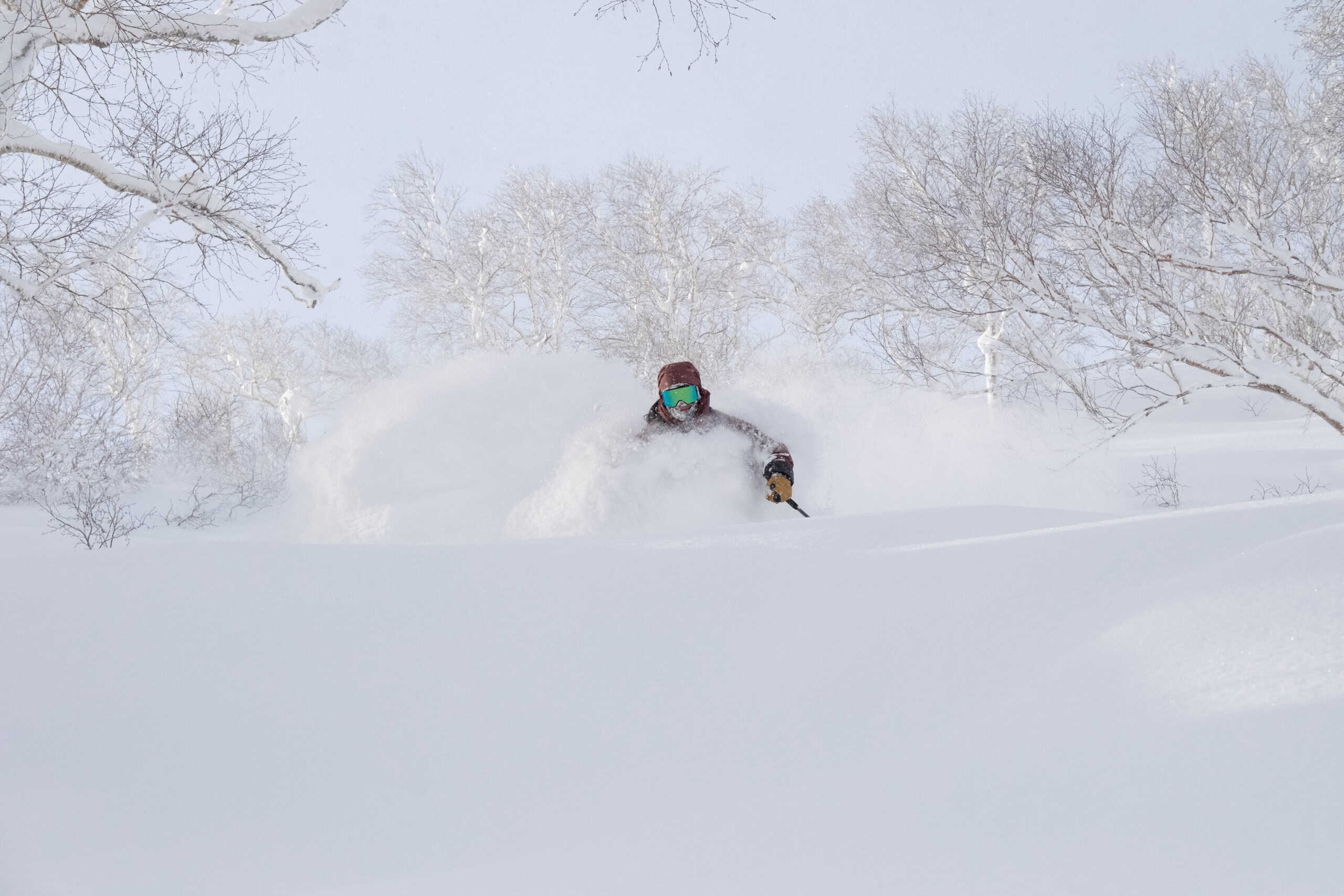
Casting our minds back to last Japanese winter, the 24/25 season was one to remember with a La Niña event delivering the deep powder Japan is renowned for, particularly on Honshu. It’s hard not to be excited about this upcoming winter, so let’s have a look at the state of play and see if we can expect similar results this time around.

Current Conditions
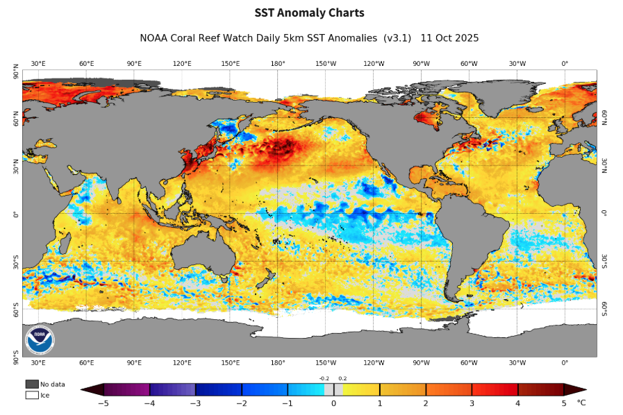
Right now, as the weather gods prepare the table for winter, we can see hints of what is to come. Below is the current global sea surface temperature anomaly and we can see a couple of fingerprints from some of the typical global models. Starting with the Pacific there is a signal that the SST is developing cooler-than-normal in the central/eastern equatorial Pacific contrasted with warm waters in the west. These are the typical conditions when a La Niña is developing.
Looking at the Indian Ocean, we can see an example of a negative IOD with warm water in the east and cool in the west. Around Japan we can see quite warm waters through the Sea of Japan and around much of the country’s coastline which may be acting to drive up temperatures.
The main takeaway here is the fingerprints of La Niña which we’ll unpack more below.
Pacific ENSO Update
As mentioned earlier a La Niña over last winter helped promote the deep Japow conditions that we know and love. Taking a more in depth look at the biggest hitter in the seasonal variability landscape, the graph below shows the relative Nino3.4 index which basically tells us the state of the sea surface in the central equatorial Pacific Ocean relative to ‘normal’.
Very warm = El Niño events and very cool = La Niña events, with the red and blue bins used as the BOM’s criteria for each respectively. You’ll notice the peak of an event occurs over the northern hemisphere winter typically December/February and after last season conditions are trending downwards towards another subsequent La Niña, which is known as a ‘Double Dip’ La Niña. Good to note that this is not rare but something that is seen after roughly 50% of La Niña events.
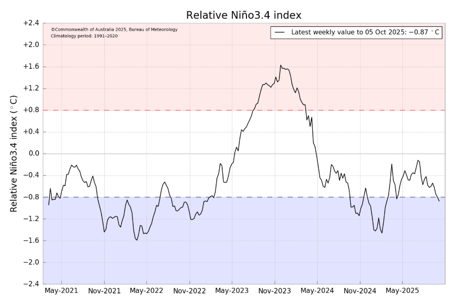
Right now we are in a La Niña watch with conditions forecasted to again reach La Nina thresholds through this winter and are already very close to reaching those thresholds. America’s NOAA ( National Ocean and Atmospheric Administration) currently says we are in La Niña conditions but the declaration of an event depends on how long these conditions persist and a little on who you ask with different criteria. The most likely scenario is a La Niña event being declared this side of Christmas then returning to netural conditions in the Pacific Ocean through the January-March period.
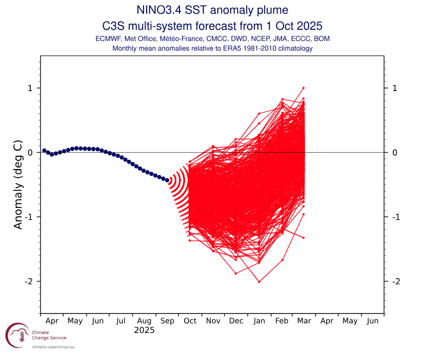
Below is a spaghetti plot showing ensemble member trends for a combined model forecast from many of the biggest global met agencies. We can see the trend further into negative (La Niña) values peaking around the Nov-Jan period before returning up into netural values, aligning with our most likely idea.
It’s always, what is ENSO but never how is ENSO?
So, a quick recap as to why La Niña is generally good news for heavy Japanese snowfalls. Well, it has to do with the East Asian Winter Monsoon (EAWM), something we’ve talked about in the past. The EAWM is the weather mechanism by where Japan’s mountainous western shores receive abundant amounts of snowfall each winter. Cold air from Siberia to the northwest of the country is driven across the sea of Japan by the EAWM, picking up tons of moisture on the way over the ocean and dumping it in the form of snow.
Good years see a strengthened EAWM consistently drive these strong northwesterly winds across the Sea of Japan. La Niña conditions help strengthen the EAWM through changes in global pressure patterns, promoting more cold air outbreaks in that continental Eurasian region and stronger northwesterlies over the Sea of Japan.
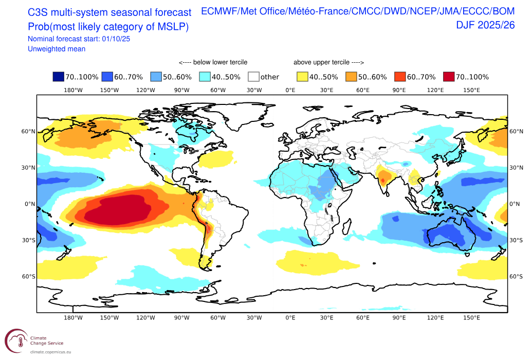
Below is a forecast product of the same mix of leading agencies for the most likelty category of mean sea level pressure (MSLP). Broad low pressure over the West Pacific and Indo-Pacific and higher pressure through the central eastern Pacific and Aleutian Islands is indicative of a La Niña signal. Looking more specifically at Japan, low pressure around and to the southeast of the country can be thought of as La Niña’s way of communicating to higher latitudes. This low pressure around this region and slightly further, helps promote the northwerly winds indicative of the EAWM.
JMA’s Thoughts
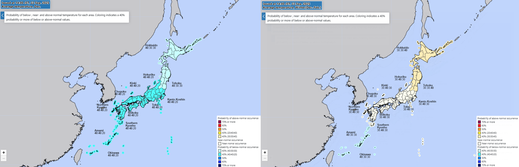
According to the JMA (Japan Meteorological Agency) temperatures in the lead-in to winter through November are expected to be slightly warmer than average. Temps then switch a cool December and then remain mostly average over the winter season.
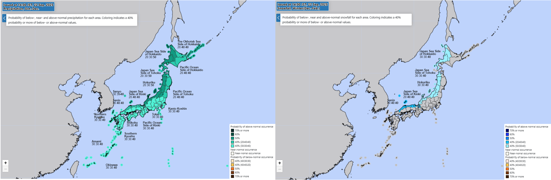
Wetter than normal conditions are expected through the lead in and this should continue through the winter with the JMA’s outlook, with the predicted development of a La Niña event early into winter, calling for an above average snowfall.
Wrap it up
Fair to say our first look at the Japanese season is promising and if you’re planning a trip to Japan, you should be happy. To sum it up quickly: the likely development of a ‘Double Dip’ La Niña through the end of this year promotes a snowier than average season through strengthening the EAWM.
However, to play the contrarian, it is still October and when dealing with Mother Nature we must remain vigilant. Revisiting some of the current state of play. we are on La Niña watch right now with high chance of an event developing this year. The JMA have 40% chance of above average winter snowfall and 70% of at least average-to-above average. I’ll keep the antennae dialed in as the days grow cooler and stay tuned for another update in a month’s time.


