The Grasshopper’s Weekly North American Forecast – 2 metres for Canada’s Coast Mountains
Mountainwatch | Grasshopper
Howdy partners, this is your faithful Grasshopper bringing you the first forecast of the 2018/2019 northern hemisphere snow season. Now that the season is ramping up, I will be bringing you these forecasts on a weekly basis, covering all meteorological highlights and lowlights that I can feel out with my super sensitive antennae.
Wednesday 12 December (Pacific Time)
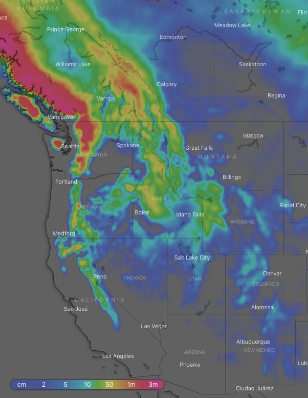
Looking at the overall picture for the next ten days, storms rolling in from the Pacific should dump around 2m-2.5m or more onto the coast mountains of Canada, wowzers! The Cascades will follow close behind with snowfalls in the 1m-1.5m range with 2m on the most exposed peaks in the north. Some of that good sauce will spill over onto the Rockies, with the Canadian portion looking set to receive 50cm-1m. Snowfalls will gradually decrease as we head south along the Rockies, but Idaho, Montana and Wyoming can still expect a range of 30cm-60cm to fall, while only 10cm-15cm is expected further south as this area will be dominated by higher pressure. Snowfalls also decrease as we head south along the Pacific with 15-30cm expected for most of the Sierras.
Thursday:
A S-SW flow will pump snow onto the Coast Mountains and the northern Cascades, with decent snowfalls also making onto the Canadian Rockies. Meanwhile, a big high lying smack bang over the American west will nudge off any remaining snow showers over the southern half of the American Rockies during the morning, leaving mostly fine weather.
Friday:
Truckloads of snow will fall on the Coast Mountains as a low crosses the Canadian coast, while snow showers will ease for a time over the Canadian Rockies. A front extending south will also dust up the Cascades and northern Sierras from afternoon. The big high will continue to dominate the American Rockies, but snow showers will move on in over Idaho and Montana late in the day.
Saturday:
Any snowfalls will peter out during the morning as a high and ridge dominate.
Sunday:
The next weather system rolls in from the Pacific with a northerly airstream dumping snow on the Coast Mountains, but it’ll be a bit warm and wet as it hits the Cascades and northern Sierras later in the day. Snowflurries will also spill over to the Canadian Rockies from afternoon. High pressure still dominates the American Rockies.
Monday:
Snow showers spread over the American Rockies, while it eases elsewhere. However, late in the day another front comes off the Pacific and dumps snow in the usual places of the Coast Mountains, Cascades and northern Sierras.
Tuesday:
The westerly airstream will push further inland and kick off good snowfalls for the Rockies of Canada, Idaho, Montana and Wyoming. Meanwhile, it’ll keep dumping on the Coast Mountains and Cascades, while it peters out over the northern Sierras.
Wednesday:
Snow will continue to come down over the Coast Mountains (does it ever stop?), while it clears from the southern Cascades. There’ll be smatterings of snowfalls over the Rockies of Canada, Idaho, Montana and Wyoming. High pressure further south will keep the southern states fine and frosty.
Next Thursday:
A cold front will work its way SE, followed by a cold N-NW flow. This will provide some good light fluffy snowfalls for the Rockies of Canada, Idaho, Montana and Wyoming, while the Coast Mountains and Cascades will get more than their fair share. High pressure continues to ward off any snow for the southern states.
Outlook for next Friday and next weekend:
The high over the American Rockies may briefly break down, allowing some cold air to spill over the southern half of the American Rockies. Snowfall amounts look small, but at least it’ll keep the dream alive. Another front is likely to roll in from the west with the usual candidates copping it i.e. the Coast Mountains, Cascades, maybe northern Sierras, as well as some spilling over to the northern half of the Rockies.