Grasshopper’s 2025 Australian Snow Season Outlook – Neutral ENSO but Above Average Temps
Mountainwatch | The Grasshopper
As the days get a little shorter, darker and cooler we know that winter is on the way, so it is time to think about what’s in store for the Australian winter season. After the past two winters that saw above-average temps in the back half of the season, we are all looking for a more ‘normal’ winter with at least a few strong cold storms out of the west.
It is early days, and remember this outlook is not a snow forecast, but an observation of current climate drivers and how that may influence the upcoming Australian winter.
Who’s behind the wheel?
Typically, the elephant in the seasonal forecast is the El Nino Southern Oscillation (ENSO) but this year, after a La Nina event peaking over the Australian summer, the state of the equatorial Pacific has returned into neutral values. So, it will most likely not be the key contributor in the state of the coming winter.
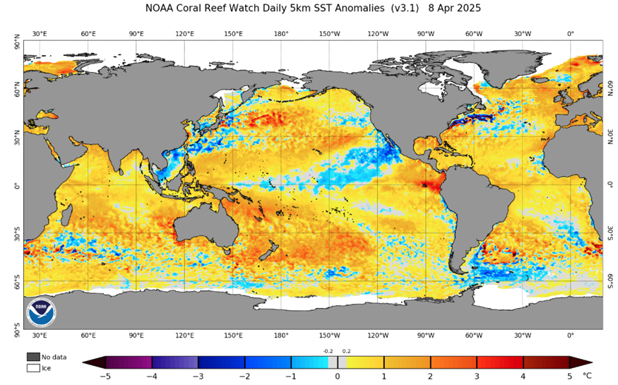
Below we can see a stalwart of the seasonal forecast, the global SST anomaly plot. Right now, it is broadly unremarkable in terms of typical climate drivers although Australia is surrounded by historically warm waters. Forecasts have ENSO remaining neutral until possibly the end of winter and at this point neutral is the most likely outcome.
This means the door is ajar for other drivers to leave their mark and one such player is the Indian Ocean Dipole. The IOD can have noticeable impacts on the Australia climate through the collection of cooler or warmer waters to the northwest of Australia in the eastern Indian Ocean. A negative phase sees this area warmer than average, enhancing convective activity and increasing the available moisture for snow-bearing systems hitting the alpine region in the form of fronts or northwest cloud band events. A positive IOD typically is categorised by the opposite.
So which one is it this year? Well, the answer comes with some caveats of course. IOD events typically peak in the Australian winter but are notoriously hard to predict through the lead up at this time of year. Right now, the conditions are in the positive range with global ensemble models gradually shifting towards negative through the next six months.
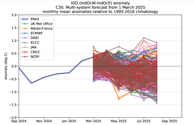
Below is a plot showing the main index for determining IOD phase for individual ensemble members of many of the best global models throughout the next few months heading into winter.
For those who aren’t sure what ensemble member means, think of them as possible scenarios with model outputs the result of averaging these scenarios to find the most likely. First thing we notice is that it is messy, but we can see a gradual trend heading in the negative direction through winter, but mostly remaining in neutral values until further into the winter season.
What does all the neutrality mean?
With both ENSO and IOD forecast to be largely neutral with possible shifts towards event thresholds towards the end of the winter what should be expect? As a result of these two being neutral it leaves the climate open to be more impacted by sub-seasonal mid-scale drivers such as the Madden Julian Oscillation and the Southern Annular Mode (SAM) and unfortunately climate change.
These drivers’ inherent nature acts in shorter timescales and predicting their behaviour from now is unreliable. However, these short mid-range drivers do have an impact, a negative SAM for example, sees the sub-tropical jet move north. That in turn allows the polar jet to also move north which means more chance of snow as it allows cold fronts to cross our alpine resorts.
Another thing that could be more of an impact in the absence of strong climate driver signals is climate change with the global SSTs so far in 2025 the second warmest for each month on record behind only last year.
Below we have seasonal products from the Bureau of Meteorology and a multi-model product combining many of the leading global models for Temperature and Precipitation and it’s not painting a very optimistic picture.
Firstly, we’ll start with the Bureau of Meteorology outlook for the next three months encompassing the May-July period. Starting with temperature the lead in to winter has a high likelihood of being warmer than average with notable what is not pictured here a very high chance of unusually warm minimum temperatures. As for precipitation it’s not great news either, most likely drier than average about the southeast and the ranges.
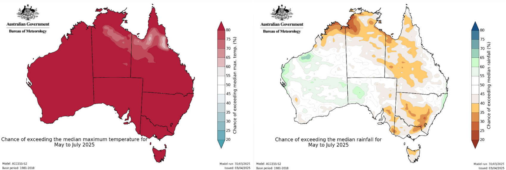
Bureau of Meteorology seasonal outlooks for the three-month period May-July for Temperature (left) and Precipitation (right). High likelihood of warmer temperatures across the country and a more moderate likelihood of drier conditions in the southeast about the ranges. Source: Bureau of Meteorology
Now, looking at the winter period of June – August (one month further into the future than the above outlooks) we see a largely similar story for temperature on the left showing the most likely temperature at 850hPa (approximately 1500m elevation). On the right precipitation looks slightly better with neutral to slightly wetter conditions expected but if coupled with abnormally warm temperatures it may not necessarily mean better chances of snow.
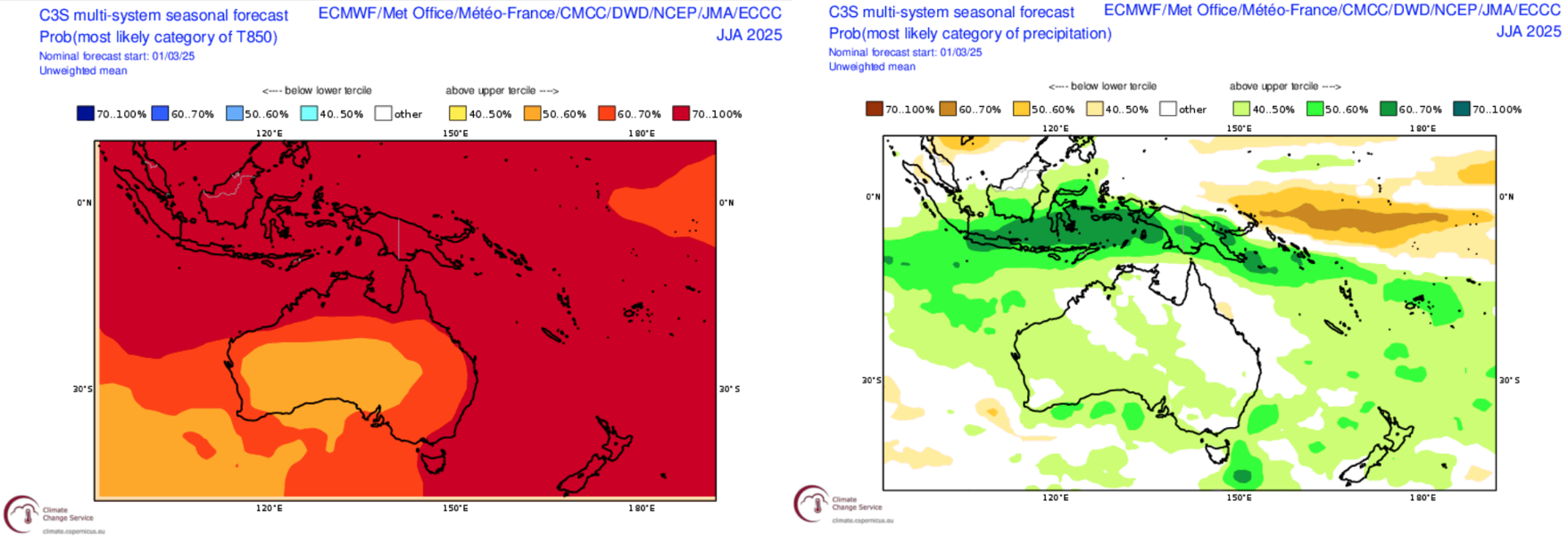
As already mentioned because of the neutral state of major drivers ENSO and the IOD being forecasted conditions should be more impacted by climate modes on shorter timescales so large storm systems are still very much in play. However, the theme of warm temperatures doesn’t bode well for lower elevation resorts with the potential for rain or prolonged warm weather to threaten the longevity of the snowpack.
Summary
Overall, our first look at the season ahead does present some challenges. With no clear driver taking the reins and climate change still a present threat, this season could go either way. There will still be storms with short-term drivers influencing their frequency and quality. it We will follow how the signals develop in the lead up to the season and keep you informed with what to expect for the season ahead.
As in any season, it’s often about timing, and the best way to time it right is to keep a handle on weather forecasts, which you can do right here on Mountainwatch with top-of-the-line model data, and detailed forecasts by yours truly starting early June.
That’s it from me folks. If you’ve got a different theory on what’s going to happen this winter, or just want to provide feedback, then please hit me up on Facebook and hit the follow button while you’re at it.


