Grasshopper’s Japan 2025/26 Snow Season Outlook, November Update – Above Average Snowfalls Still on Track
Mountainwatch | The Grasshopper
One month down since our first outlook for this year’s Japan season and while there is some snow is on the peaks, but we are still waiting for things to get properly underway.
Happy to say that in the short term there’s some consistent snow in the immediate forecast across Japan, favouring resorts on Honshu which could pick up 15-20cms over the next two days. There is potential for heavier falls next week with some models picking a nice low-pressure system moving through the Sea of Japan.
But enough of the short term, let’s dial back into what our story is for the rest of the season building upon initial investigations last month. As you might remember our most likely analysis was for a La Niña event peaking in the first half of the season leading to neutral to above average snowfalls across Japan’s resorts. There was also the possibility for some cold temperatures heading through December followed by possibly warmer temps in the back end of the season, particularly up north. Time to jump back in and see how that plan has evolved.
Quick ENSO Review
Not much has changed with regards to ENSO. Conditions are currently indicative of a La Niña event with NOAA calling a ‘La Niña advisory’ and predictions remain for this event to peak in the first half of the season and taper back to neutral through the end of winter. Below is the spaghetti plot from last month against this month’s model runs on the right. It might look pretty similar at first glance, but we can see increased confidence of that trend with a quick return to neutral values in the back of winter/start of spring next year. Right now, the background level of the Pacific which has its own name, the Pacific Decadal Oscillation (PDO) is also negative which promotes the La Niña conditions and can help to reinforce its strength.

Deeper Dive
So, we have a La Niña event that’s not super strong and most likely weakening to neutral. Is that all? I’m glad you asked, but no there are a couple other things we can delve into. As mentioned in past outlooks, the East Asian Winter Monsoon (EAWM) is the key driver in typical Japanese dumps. But what else can help drive cold air outbreaks from the northwest over Japan?
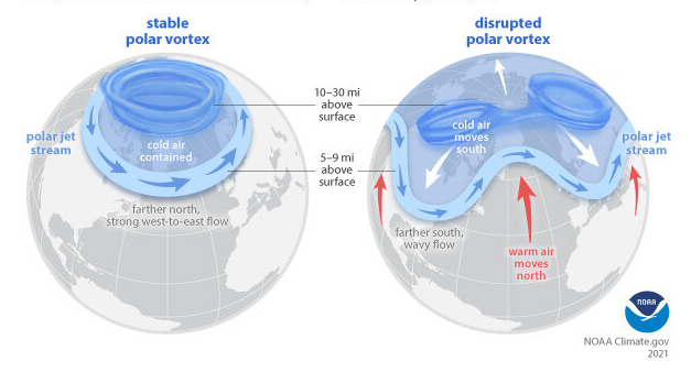
The Polar Vortex
Without going into too much unnecessary detail around the poles, the Polar jet circles the north pole and is strongest in winter. A stable polar vortex sees the coldest air confined to the poles but instability or weakening in the Polar Vortex can see deviations in the path of the polar jet, bringing cold air to higher latitudes. These events typically lead to cold weather and heavy snowfall outbreaks. To check the state of the Polar Vortex we look at the wind strength in the upper atmosphere with a weakening or even reversing of the winds a sign of that destabilisation.
New Acronym Alert
Okay, stay with me now. What can help us forecast the Polar Jet? La Niña itself can help contribute to the weakening of the Polar Vortex, but I have another acronym for those playing at home – the Quasi-Biennial Oscillation (QBO) which describes the regular periodic shifting in the direction of the equatorial zonal winds (east/west) in the lower stratosphere.
Right now, that wind is easterly, which is important because in this regime we are more likely to see a weakened Polar Vortex typically lead by Sudden Stratospheric Warming (SSW) events. These events see anomalous warming in the stratosphere at the poles and weakening of the Polar Vortex, providing cold air outbreaks and big snowstorms to the higher latitudes, including Japan.
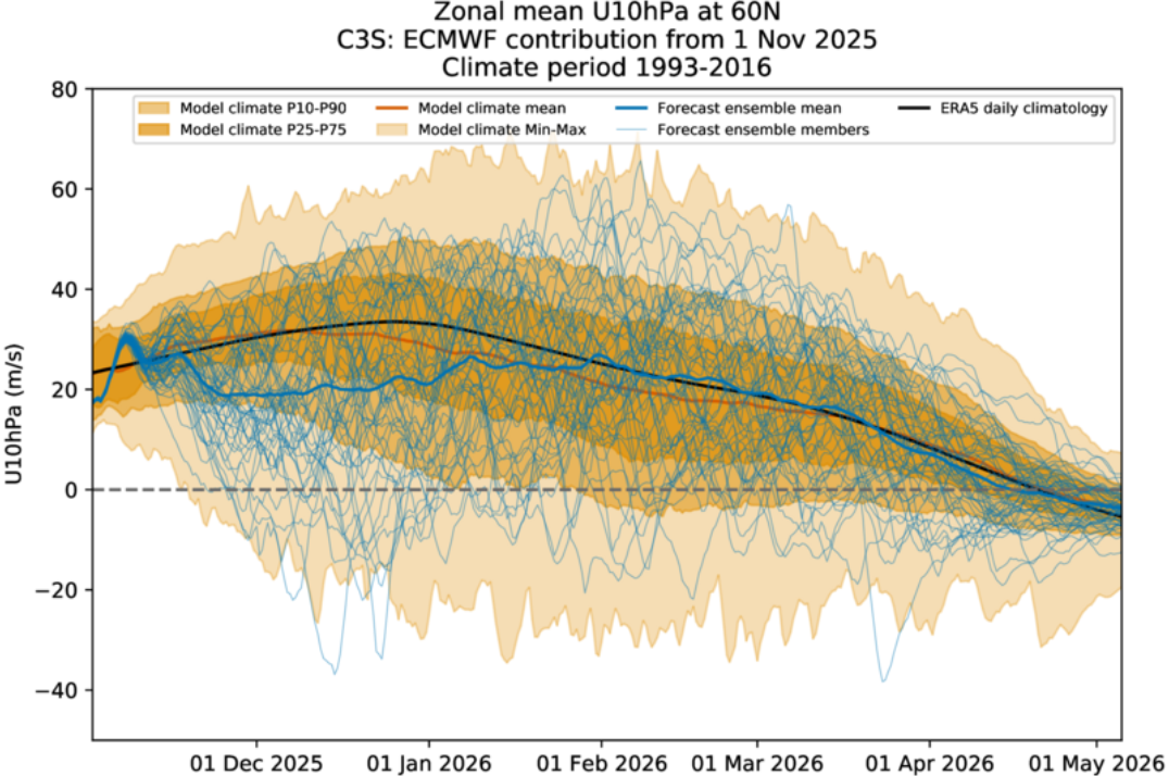
The plot below shows the strength of the zonal wind at 10hPa up in the atmosphere at 60°N, which indicates a likely weakening of the polar vortex. Think of it as the strength of the polar vortex with the black line showing a climatological mean from past values and the blue showing the mean of all the ensemble members. We notice the blue is below the mean through December and January and returns to pretty much normal around February.
Okay Hopper, get to the point.
This is important because an SSW event is forecasted to occur soon which will leading to early season cold temperatures in December I mentioned in the previous outlook.
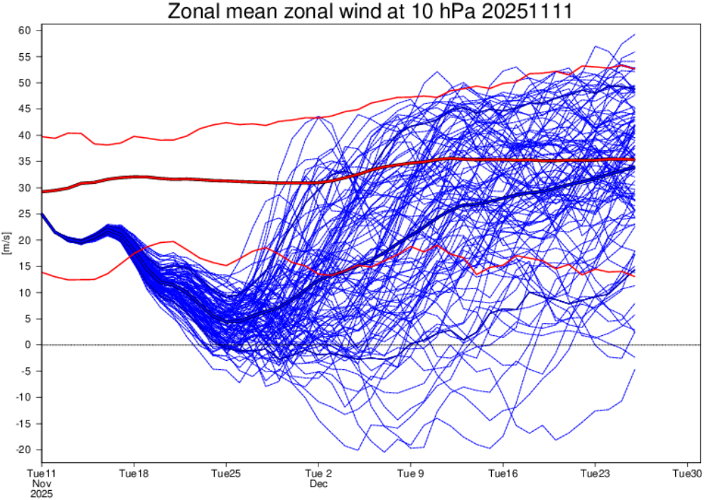
We see this below in the weekly ensemble member forecast of the zonal wind at 10hPa at 60°n, similar to the previous plot except this is on a shorter timescale. There is a forecasted dip throughout the end of this month which may act to drive some cold air outbreaks and snowfalls over the next two-to-three-week period across the northern hemisphere. Based on the longer-term plot, this kind of event will become more important moving into the thick of the season particularly through Dec/Jan and possibly early February.
Seasonal Products
Our long-term narrative remains the same as last update with a neutral to above-average season the most likely outcome. There haven’t been any major shifts from the long term products which is a good sign. Temperatures still look to be neutral to above average also which may hinder the length of the season.
Wrapping it up
Our current Japan outlook remains the same, we are still looking at an average to above average winter thanks to conducive Pacific Ocean conditions with La Niña conditions expected to peak earlier in the winter and transition back to neutral next year. Other background players may act to encourage some extra sauce like a weakened polar vortex throughout the season, but this is harder to predict on the longer-term scale. In the short term a forecasted SSW event through the end of November should lead to some snowy weather which will hopefully help us hit the ground running come December.
Stay tuned for my weekly Japan forecasts, due to start in mid-December. In the meantime check out our twice daily automated Japan forecasts and snow cams to stay across conditions as we head into what is looking like a promising winter.