2025 New Zealand Snow Season Outlook – Neutral ENSO, Above Average Temps
Mountainwatch | The Grasshopper
Welcome to the first of our New Zealand seasonal outlooks for the 2025 winter season. After a slow start but solid ending to last year’s season, what can we expect this year? If you’ve been keeping up to date you might know that we are coming off a weak La Niña event over the northern hemisphere winter and major climate drivers have returned to neutral.
In this first outlook will make some observations of what that may mean for the upcoming New Zealand ski season.
ENSO
As mentioned earlier, we saw a La Niña event develop over the northern hemisphere winter and while sea surface indicators have returned to neutral levels over the past couple of months there are still some lingering fingerprints of La Nina-like conditions in the global circulation.
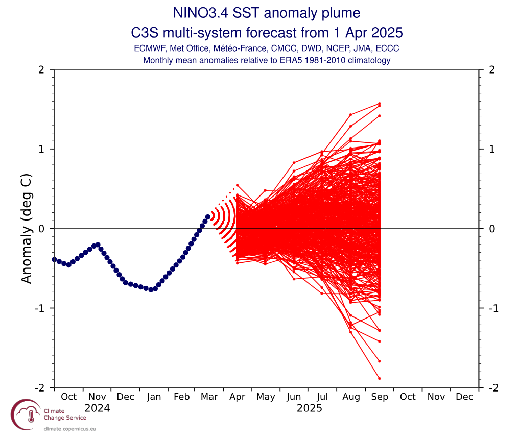
Looking at the El Niño Southern Oscillation (ENSO) there is solid consensus between global models that conditions should return well into the neutral range over the next six months with hints of a possible dip back into La Nina territory after the southern hemisphere season. This is shown in the graph below, with forecasts of the development of SST (Sea Surface Temps) in the Nino 3.4 region through the coming winter period. This region is widely used as the most accurate indicator of ENSO phase. All the different red lines represent different model simulations with consensus being that neutral values are the most likely outcome through the southern hemisphere winter.
Unlike many other popular snow areas of the globe, a La Niña is typically bad news for the New Zealand ski season. On the flip side El Niño is typically better news, categorised by low pressure to the southeast of NZ encouraging cold air from the south and more southwesterly wind regimes bringing snow bearing systems.
So… what does a neutral scenario mean?
Commonly for a neutral scenario we see higher than average pressure to the southeast of New Zealand, which lends itself to east-northeast wind regimes. This east/northeast air flow reduces the chances/frequency of strong cold outbreaks from the southwest, which are necessary for the larger snow storms we want to see.
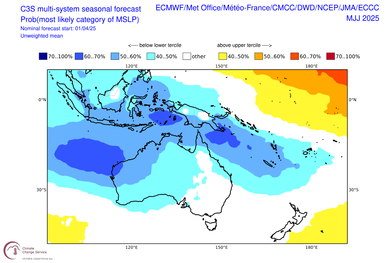
Below we have two forecast products: the first map shows the forecasted three-month MSLP (mean sea level pressure) for May-July and the second shows the MSLP for June-August. Heading into the winter season the first map shows this situation with high pressure to the southeast with low pressure to the northwest sandwiching New Zealand. This pattern promotes those undesirable east-northeast winds.
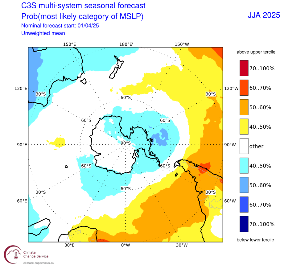
The second map, showing one more month into the future, suggests these anomalous areas of high and low pressure move slightly further to the southeast but still suggesting the same pattern.
Other Influences
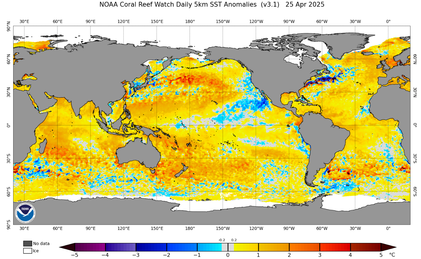
Global sea surface temperatures since the start of the year have been historically warm with average SSTs only eclipsed by last year’s numbers. Around the Aus/NZ region is no different, with anomalously high SST surrounding New Zealand. As you can see in the below illustration of the global SST anomaly, New Zealand is surrounded by warm waters. Although this can mean more moisture available for storm systems it also can lead to warmer temperatures and hence a rising freezing level, which is less than ideal.
Other Seasonal Products
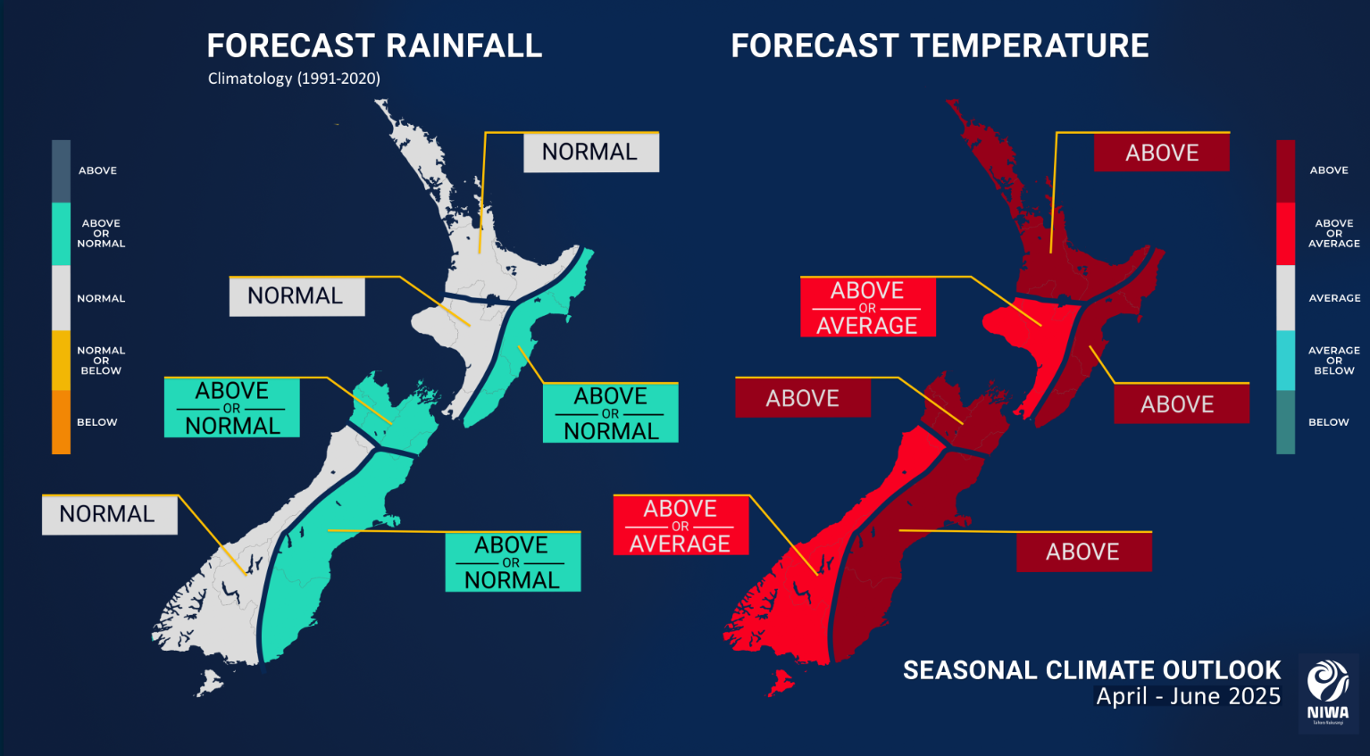
New Zealand’s National Institute of Atmospheric Research (NIWA) forecast product for the upcoming three months hints at what we have been speaking about – Warm temperatures are likely throughout the country, but precipitation is expected to be mostly normal. The eastern side may see slightly more precipitation which agrees with our assessment of a most likely east-northeasterly wind regime.
Summary
Overall, heading into the winter season the outlook is not ideal, with long range forecasts calling for warmer temperatures and perhaps less regular southwesterly storm systems that we know and love. However, it’s also not all bad news, as smaller timescale influences like the Southern Annular Mode will come in to play during the season, potentially helping to tap into cold air to the south.
One concern is that if the warm temperatures persist, we may see freezing levels remain high which does not bode well for the resorts at lower elevations. But remember this is our first investigation and it is only April we will stay tuned to see how the climate develops heading further into the year.
As in any season, it’s often about timing, and the best way to time it right is to keep a handle on weather forecasts, which you can do right here on Mountainwatch with top-of-the-line model data, and detailed NZ forecasts by yours truly starting early June.
That’s it from me folks. If you’ve got a different theory on what’s going to happen this winter, or just want to provide feedback, then please hit me up on Facebook and hit the follow button while you’re at it.


