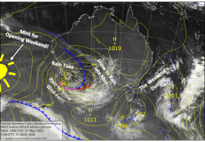
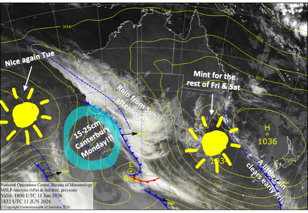
New Zealand Forecast – Nice for Fri & Sat, Snow for Canterbury on Monday
Published early Friday, 12th June 2026
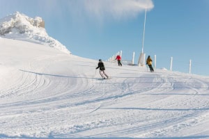
Well, winter has been slow off the mark this year, and despite their best efforts, The Remarkables has rescheduled its Opening Day for Saturday the 20th June. Cardrona has also rescheduled for that day, and Mt Hutt is hoping things will improve for a potential opening sometime in the next 7-10 days. Coronet Peak already has some learner slopes open thanks to its Snow Factory and is still on track for a second opening, with increased hours and facilities.
We’ll have mostly fine weather for the next couple of days on the heels of a damp weak front. Then, through the latter half of Saturday, a front will cross the Southern Lakes, bringing mostly just rain and possibly a little snow up high. As the front continues up Canterbury on Monday, cold southerly winds get into the mix, and we’ll see snow falling to low levels, leaving around 15-25cm of pure white gold on ski fields there.
Friday 12th June
A weak front that passed over the Southern Lakes during the night continues northwards over Canterbury during the morning, bringing cloud and a light shower or two. Skies will clear in the afternoon, but temperatures will be marginal for making snow overnight.
Meanwhile, down in the Southern Lakes, any leftover cloud will clear in the morning for a nice, sunny day. The snow guns will also get a good run at night with chilly temps.
Saturday 13th June
Scheduled Opening Day at Coronet Peak will be mint, as a ridge of high pressure moving up the country brings clear, sunny skies and northwest breezes to South Island ski fields. There’ll likely be more snowmaking overnight for the Southern Lakes, thanks to chilly temps there, but it’ll be too balmy in Canterbury.
Sunday 14th June
Day 2 of the season for Coronet Peak will see rain developing over the Southern Lakes in the afternoon as a more active front from the west passes over. A little bit of snow may fall above about 1900m at first, but it’ll all quickly turn to rain. The rain clears overnight as the front ships off to the north. Winds from the northwest will be strong in exposed areas.
Canterbury will stay clear and dry, but northwest winds will be strong and chew up much of the man-made snow.
Monday 15th June
The front crosses Canterbury during the morning. Rain will quickly turn to snow as cold air from the south floods in. We’ll see good snowfall through the afternoon, while snow levels continue to drop, possibly eventually reaching as low as 700m before clearing at night. Totals of around 15-25cm are expected for this event, which will go a fair way toward getting things rolling.
The Southern Lakes largely miss out on the snowfall event, but cold southerly breezes may bring a few light flurries and have the snow guns cranking.
Tuesday 16th June
A nice fine day with a chilly start for South Island ski fields on the heels of the cold front, but mild west-to-northwest winds will quickly warm things up.
Extended Forecast
Another cold front is picked to cross the South Island on Wednesday, the 17th of June. This one is expected to weaken as it tracks northwards, so Canterbury may only receive a dusting at best, while the Southern Lakes is in line for a small shot of snow. Conditions for making snow will be great for a couple of days.
After that, a shot of snow is on the cards from a storm rolling over the country between Friday, the 19th, to Sunday, the 21st June. It’s still a wee way off, and could lead to rougher conditions for rescheduled Opening Days.
That’s all from me today, folks. I’m sending out NZ forecasts every Monday, Wednesday and Friday throughout the season. Have a great weekend, and I’ll see you back here on Monday.
Grasshopper