Australian Weekend Forecast, July 21st – Chilled Out And Chilly While Another Weak Front Goes M.I.A.
Mountainwatch | The Grasshopper
Written early Friday 21stJuly, valid Sunday 23rdJuly
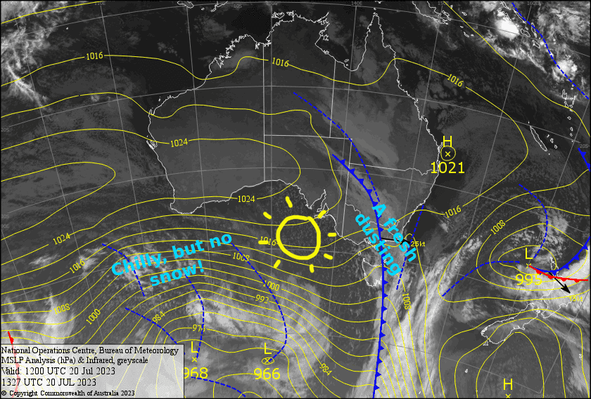
The weak front passed over last night, leaving us with a sprinkling of snow above 1600m and chilly SW winds. The breeze will die away Saturday as a narrow ridge of high-pressure pushes on ahead of what seems like the 101stweak cold front. This one, however, goes missing in action, somehow disappearing upon reaching us, and coughing up only a few showers for Baw Baw, which is on the south side of the Dividing Range. On the positive side, temps will remain fairly cold, and no strong winds or adverse weather is expected.
Friday 21st
A partly sunny, partly cloudy day, with chilly SW winds. Light snow showers will start to pop later in the morning, with one or two expected at most resorts at some point.
Saturday 22nd
A mostly fine day, but cloud will build over Victoria during the afternoon. S-SW breezes dying away.
Sunday 23rd
Another mostly sunny day, but a S-SE breeze will blow in a bit of cloud, especially during the afternoon with showers of snow/rain likely over Baw Baw.
Extended Forecast
High pressure will then keep a lid on things through until mid-next week. A cold front + low combo is expected to hit either Thursday or Friday, with snow falling to at least mid-slopes possibly through into Saturday. At this stage, we could be looking at somewhere between 10-30cm, which would be more than welcome.
That’s all from me today, folks. See you again Monday.
Grasshopper


