Forecast – New Zealand – Extended Outlook
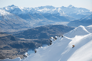
The end of April saw some significant snow hit the Queenstown resorts, here’s hoping the end of May sees the cold weather return. Image:: Coronet Peak
Mountainwatch | The Grasshopper
Tuesday 20 May 2014
Kia Ora folks. Yesterday we published an extended outlook for the Aussie Alps, just to give a taste of how things might be looking come opening weekend.
Now, that was relatively straightforward for the land of Oz. Firstly, there wasn’t a lot of weather to talk about. Second, most of the major resorts there “open” on the same weekend, although I use that term loosely.
For New Zealand… Sigh… I’ve picked a bigger battle. Everyone gets going at different times, and we’re still more than five weeks away for some. So what I can do today is concentrate on the first two cabs off the rank – Coronet and Mt Hutt – who open on June 7, same day as the Australian resorts. That will at least cover the Southern Lakes and Canterbury. And for the Ruapehu crew we’ll have a bit of a poke around to see how early June is shaping up.
South Island:
There’s a slightly insane amount of rain hitting the Southern Alps this week. The first burst peaks from tonight into Wednesday morning. It’s not going to matter for Coronet, where things are brown as. For Mount Hutt, the mixture of rain, high freezing levels and strong north-westerlies is going to chew into some of the base they’ve been coaxing along since early May.
The situation is looking up by Wednesday night. We get a fairly decent cold change move through, enough for a few centimetres of snow. Unfortunately, on Thursday it warms up again and another extreme period of rain starts up, running into Friday. More extremely strong north-westerlies. Too warm for snow initially.
On Saturday, another cold change moves through, with 15 to 20cm of snow possible. This would be great news, if it wasn’t for the fact that another big momma of a rain band is going to roll through around Tuesday of next week, bringing even more rain to wash away any snow that may have built up.
The saving grace of this whole affair is that the second half of next week looks like it will be cold and snow showery, especially for the Southern Lakes. Over several days it appears that temperatures will stay low as south-westerlies feed snow showers across the lower South Island. The great thing is that, in addition to some natural snow, the steadily cold temperatures should allow snow making to get into full swing, increasing the chances of a successful open day.
North Island
Be patient. That’s my constant refrain for those who want to ski the lovely Ruapehu. With all the elevation in the world, nearly every front that goes past is going to drop a little snow up high. And as winter goes on that snow line is going to get lower and lower.
Rain on Friday/Saturday will eventually turn to snow up high, and we’re in for a similar dose in the second half of next week. There’s still a long way to go between now and the opening day on June 28. But I expect we’ll continue to pick up dribs and drabs that start to look pretty good when you add them up over a month. Just remember that June is not August, so don’t book a holiday early in the season and expect to walk into two metres of snow. Unlikely to happen that way.
That’s all from the Grasshopper. Regular forecasts start next week. Got a question or feedback for me? Hit me up at grasshoppermw@gmail.com, on my facebook page, twitter, or join in the discussion below.