Grasshopper’s North American 2024-2025 Snow Season Outlook, November Update
Mountainwatch | The Grasshopper
After some good snowfalls in parts of the US and Canada over the past couple of weeks, quite a few resorts in North America already have lifts spinning and with likely heavy snowfalls on the way over the next week, winter is well and truly on the doorstep.
Starting today, a very strong storm in the Pacific will see the action over the next week focused on the Cascades in the Pacific Northwest, California’s Northern Sierras and the Coast Mountains in BC. An “atmospheric river” could result in some big snow totals, Whistler Blackcomb in line for 90+cms while Palisades Tahoe could see well over a metre of snow over the next 10 days.
Is this a sign of things to come? Maybe, as strong storms like this are not unusual in a La Niña or neutral year. Our last investigation into what we may expect this season hinted at the potential of a La Niña developing, so has much changed since my first North American season outlook? Let’s play spot the difference between that and updated conditions and discuss why things may be different.
ENSO
Last month the main story was the potential of a La Niña event developing over the coming winter. That potential is still likely, NOAA (National Oceanic and Atmospheric Administration) currently putting the chance of an event occurring at 57%, slightly down from the 60% chance we saw a month ago. Also, as discussed last month, if we do see a La Niña event reached this winter it is most likely to be weak, so its usual impacts can be dampened.
Below is a comparison of the global SST anomalies from October 13th on the left and of November 17th on the right. Overall, there is not a major difference between the two – we still have a pattern that looks like a La Niña is trying to emerge, but there isn’t any significant development. Waters around the west Pacific are very similar and there’s a slightly increased extent of cooler waters in the central-eastern regions. ENSO events do typically reach their maximum during the Dec-Feb period, so we can still expect this pattern to develop into winter.

NOAA Comparison
Before we look at the comparison between this and last months’ seasonal outlooks from NOAA and Environment Canada, I’ll quickly revisit why the pattern looks the way it does.
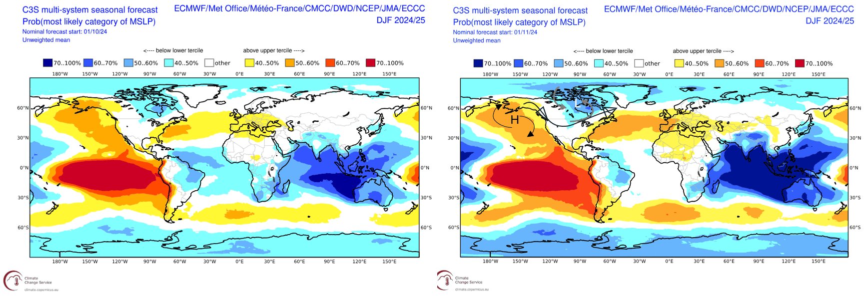
Below is a comparison between the forecasted MSLP anomaly over the coming winter. We see an area of high pressure in the Northern Pacific and an area of low pressure in northeastern Canada, which are typically present for a La Niña event. The annotated forecast on the right shows an idealised path of the Polar Jet in a La Niña like set up, with the high pressure at the surface often reaching high up into the atmosphere. This brings cold air from the north and moisture from the Pacific in the form of storms directing it over northwestern USA/southwestern Canada.
Moving to the more specific products, the image below compares NOAA’s seasonal temperature outlook from last month to this month. Spatially the pattern is very similar, the largest difference to note is the increase in area of below-average temperatures in the northwest. We can see that pattern outlined earlier and considering the likelihood of a La Niña event being weak in the Pacific, it is interesting to note the increase in the extent of forecasted below-average temperatures. That illustrates that weak events can still have impacts on seasonal temperatures and snowfall.
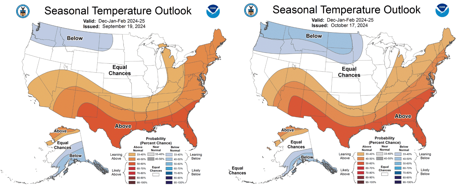
A comparison between the seasonal temperature outlooks for the coming winter from last month (left) and this month (right). Subtle differences between the two. Source: NOAA
Speaking of snowfall, the comparison map below shows the NOAA forecasted precipitation outlook for the winter, the left issued on September 19th, the tight on October 17th. Again, the pattern is very similar except for the updated version we see reduction in the extent of above average precipitation across the north. Again, the northwest is best positioned for the upcoming season.
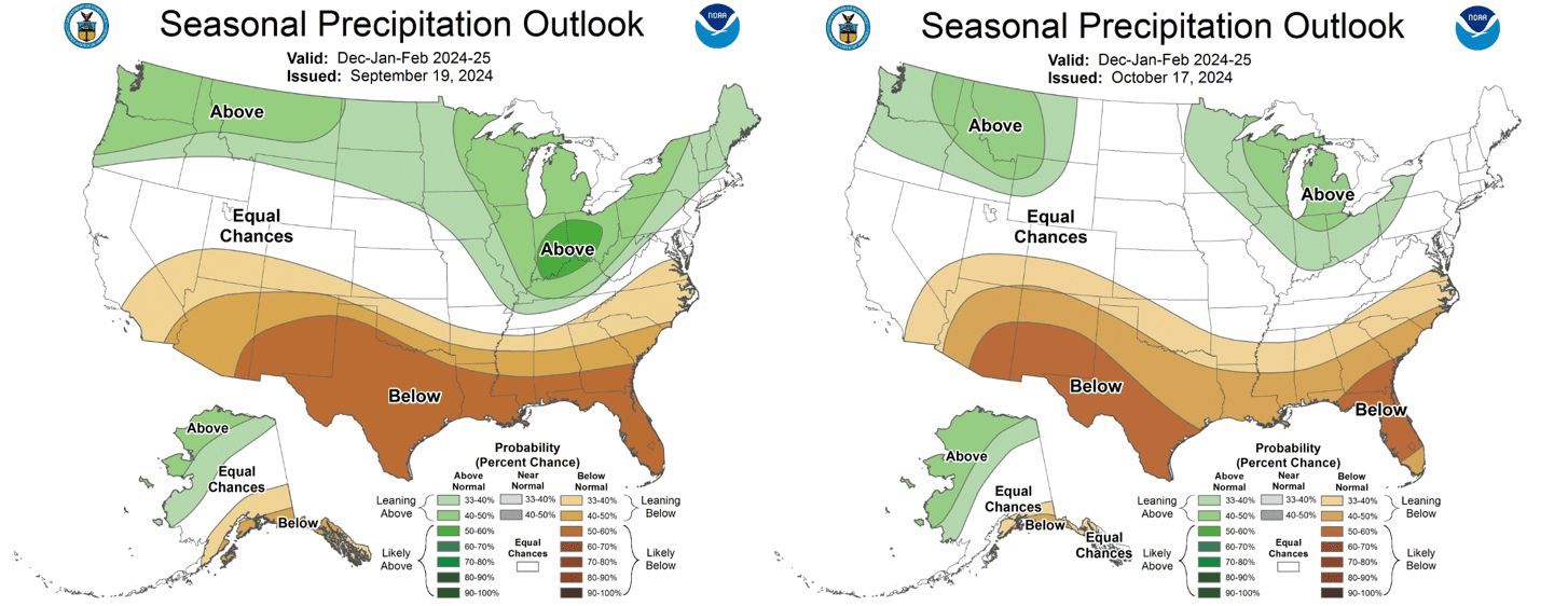
A comparison between the seasonal precipitation outlooks for the coming winter from last month (left) and this month (right). Once again subtle differences in the north and south with the main pattern looking quite similar. Source: NOAA
The updated Environment Canada seasonal forecasts against their month-old counterparts are shown below, the older forecasts run from November-January and the newer forecasts run from December to February. It is similar to NOAAs outlook and a we might have expected the southwest of Canada is best positioned with cooler than average temperatures forecasted, and the slightly wetter conditions forecasted are mainly confined to the Canadian Rockies.
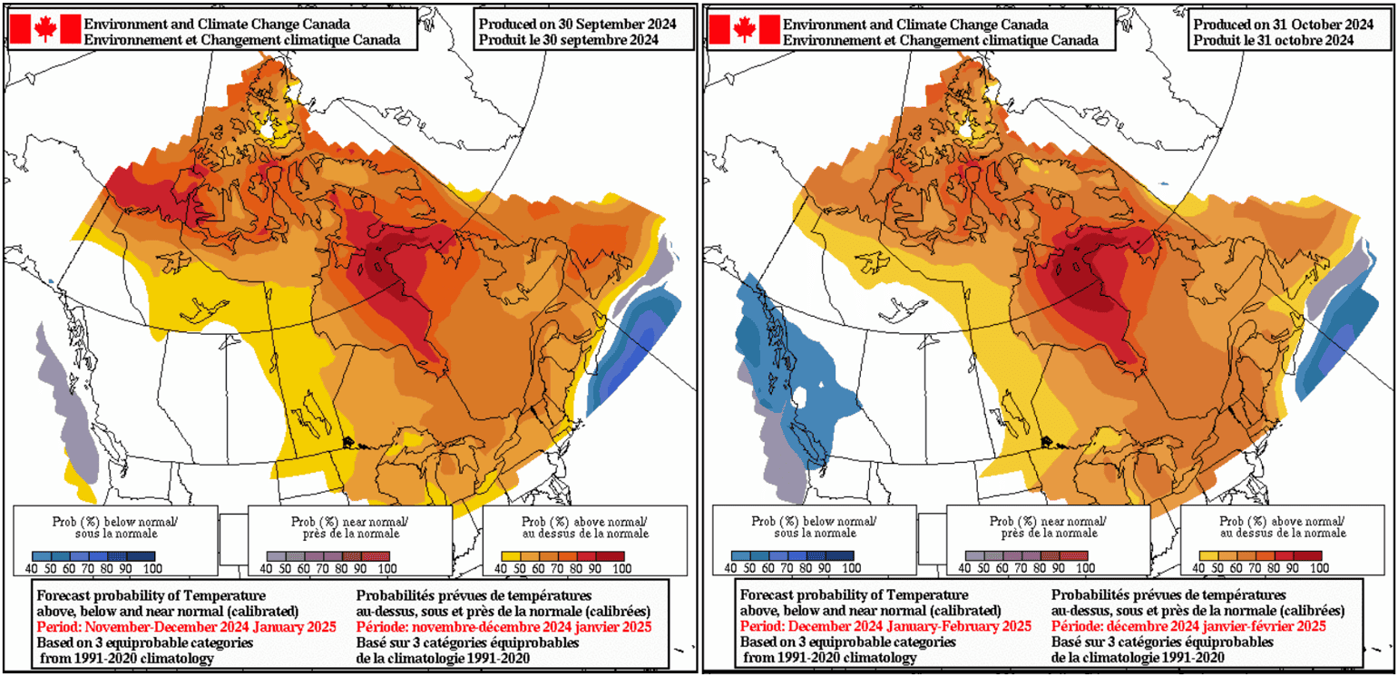
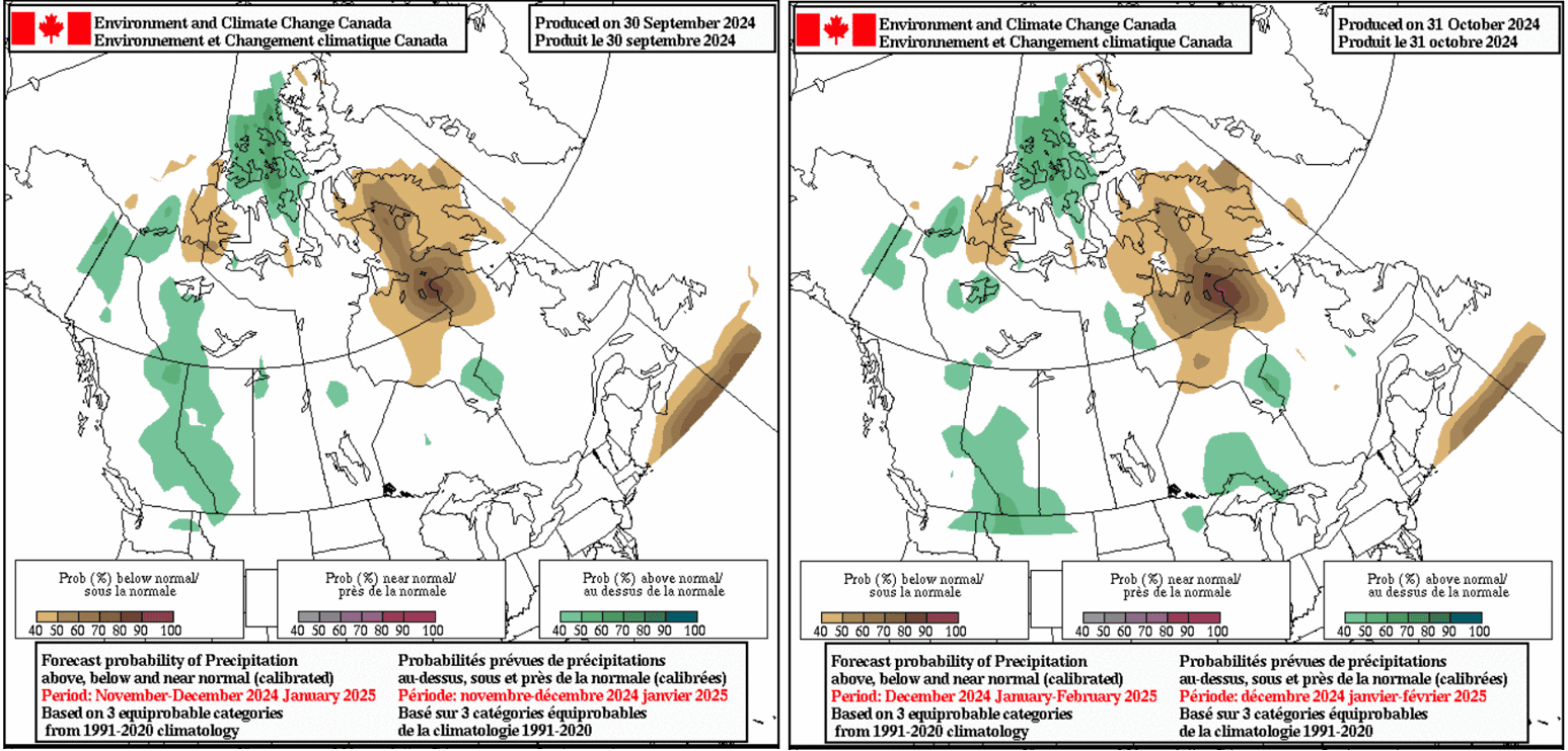
So, after all those comparisons where does it leave us? The most likely scenario at this point is a weak La Niña event peaking during the winter season. That should mean cooler, below-average temperatures and average-to-wetter conditions around the northwestern United States and southwestern Canada. Neutral conditions are expected through the more central latitudes of the United States, while further south drier and warmer conditions overall are more likely.
The result could mean above average snowfalls and colder temps for ski resorts in Oregon, Washington, Montana, Idaho and Wyoming and north of the border in British Columbia. Columbia. Of course, neutral conditions free of major climate drivers elsewhere mean everywhere has a good chance to see some decent storms and an overall good season.
I’ll have my next update in around a month’s time and stay tuned for my weekly North American forecasts, due to start in mid-December.
