Grasshopper’s Weekly Japan Forecast, Friday Feb 4th – Another Magic Week Ahead with Plenty of Powder and Sunshine Lined Up
Mountainwatch | The Grasshopper
Written Friday, February 3rd(Japan Standard Time)
It’s been a magic week here in Japan, with consistent and voluminous snowfall keeping resorts topped up and squeaky clean with deep powder.
Although it’s hard to compete with the week just been, and not as much powder is expected to fall over the coming seven-day period, we’ve still got some excellent conditions lined up.
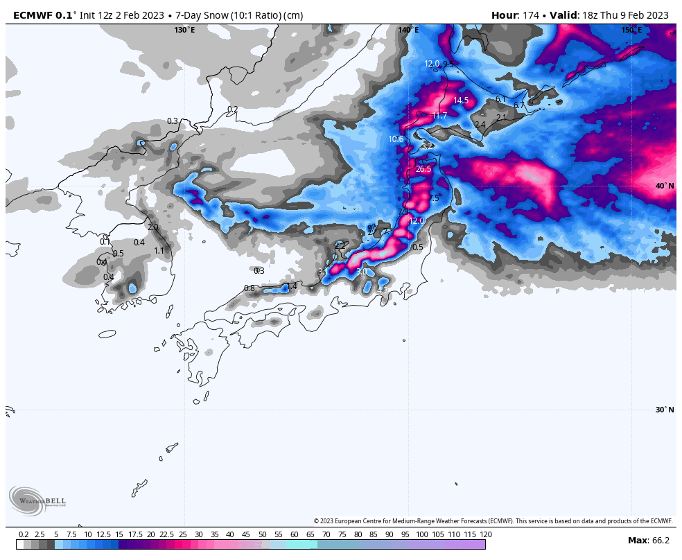
Weekly totals across most resorts should lie within the 20-50cm range, after a nice top up this weekend on Honshu, followed by a bigger snowstorm Wednesday into Thursday. Hokkaido, meanwhile, will continue to see light consistent snowfall. In between times, we should also see plenty of sunshine.
Friday Feb 4th
A cold breeze out of the NW will continue to push in light snow showers today. The further south you look, the less consistent the showers will be, especially in central Honshu where they will likely disappear this morning, but reappear later this afternoon before clearing Honshu entirely tonight.
Saturday Feb 5th– Sunday Feb 6th
We’ll start the weekend with mostly fine, calm conditions on Honshu, but a trough of low pressure will spread snowfall over central Honshu from late Saturday morning and northern Honshu during the afternoon. The snowfall will start lightly, and likely wet at base levels on central Honshu, but will become heavier late in the day as colder NW winds arrive with the snow level bottoming out once again.
Snowfall will clear central Honshu Sunday morning and northern Honshu during the afternoon as high pressure moves in, with mostly sunny skies lighting up what should be a ripper of a day.
Meanwhile, Hokkaido will continue to see light snow showers and cold westerly winds throughout the weekend, both of which will pick up in vigour for a time Sunday night.
Monday Feb 7th– Tuesday Feb 8th
Central Honshu will spend most of Monday and Tuesday under sunny, calm skies and warming temps, before mixed precip gets started Tuesday night as a low passes by on the Pacific side.
A front lying over the top half of northern Honshu will bring some rather heavy snowfall there during the first half of Monday, but will peter out during the second half of the day, leaving a partly cloudy/sunny day Tuesday.
Similarly, on Hokkaido, snow showers there will gradually clear during Monday, for a partially cloudy/sunny day Tuesday.
Wednesday Feb 9th – Thursday Feb 10th
With the low mentioned above continuing to pass by on the Pacific side, the small hours of Wednesday will see mixed precip over central Honshu spreading to northern Honshu, before freezing N-NW winds hit and we see moderate-heavy snowfall lowering to base levels over Honshu through the rest of the day. Cold northerlies will also get light snowfalls going over Hokkaido during the second half of the day.
Thursday, snowfall across the country will gradually ease as the strong, icy N-NW winds abate.
Friday Feb 11th & beyond
From late next Friday and through next weekend, models expect a deep low out of warmer climes to the west will pass over Honshu, bringing heavy, mixed precipitation, where snow levels will be uncomfortably high.
We’ll likely see settled conditions the following Monday, before a weak-moderate low-pressure system over the following day or two should bring some decent snowfall to low levels, perhaps providing the best conditions over this period.
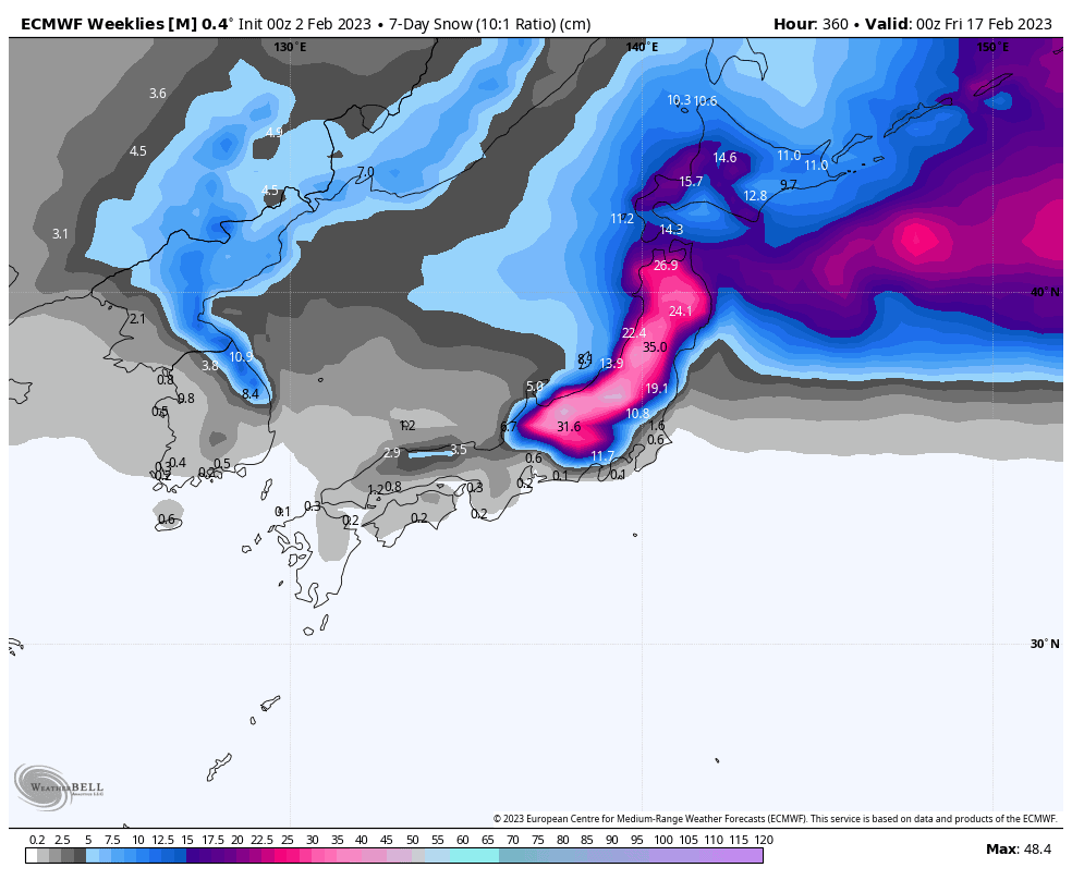
We’ll likely see settled conditions the following Monday, before a weak-moderate low-pressure system over the following day or two should bring some decent snowfall to low levels, perhaps providing the best conditions over this period.
That’s all from me this week guys, see you next week!
Grasshopper


