Grasshopper’s Weekly North American Forecast, Feb 23rd – Nowhere Spared as Continuous Storms Pile on the Powder
Mountainwatch | The Grasshopper
Written Thursday 23rdFebruary (Pacific Standard Time)
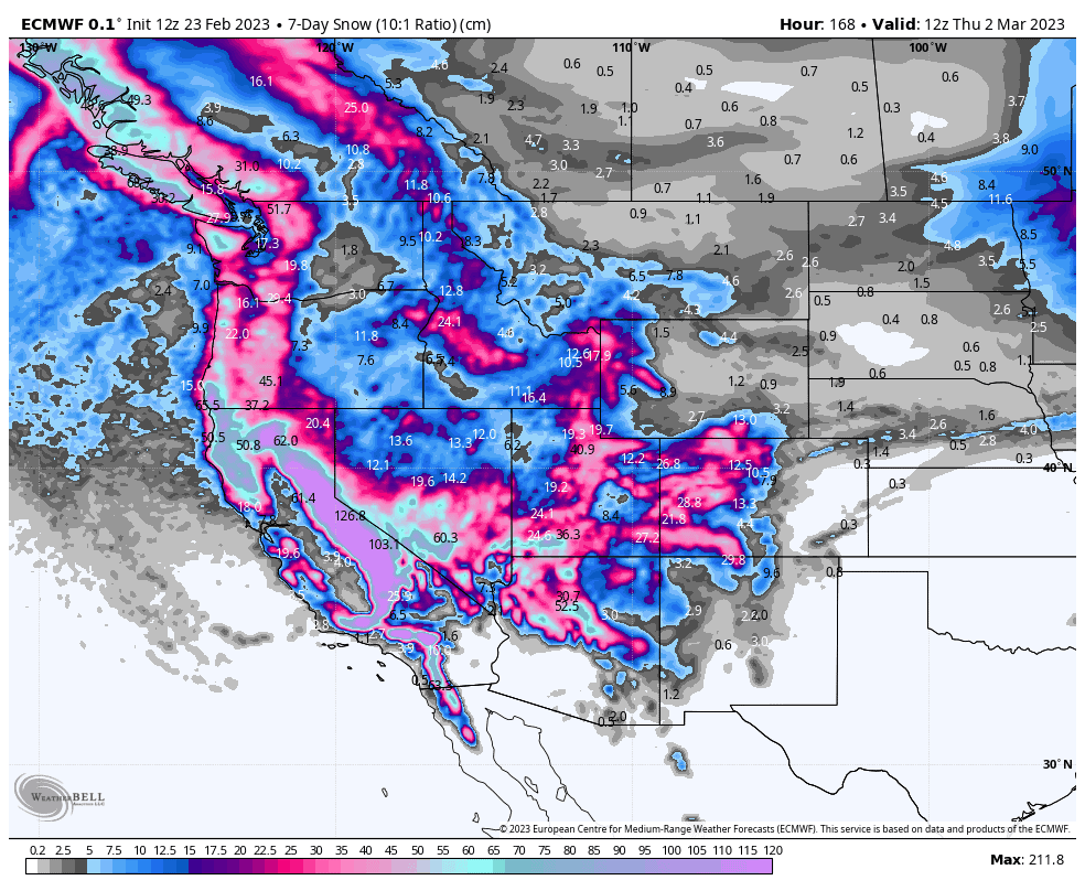
Wow we have another massive week ahead, possibly one of the biggest I’ve ever seen for the Sierras (as far as my tiny little grasshopper brain can recall).
In what will be a constant and dizzying storm cycle for the west, persistent heavy snowfall in the Sierra’s is likely to pile something like 1.5-2.5m of quality powder on top of an already massive snowpack.
Nowhere will be spared, with big totals also showing up in the central and southern Rockies, as well as the Pacific NW, with the northern Rockies also looking decent.
Thursday Feb 23rd& Fen Friday 24th
Light scattered snowfall across the west will clear northern skies today, as an Arctic airmass presses inform the north. At the other end of the spectrum snowfall will become heavy in the Sierras as a low tracks down the Pacific coast.
The southern Rockies with also cop some decent snowfall, as light scattered falls there become fairly heavy in some areas during the latter half of today before clearing out Friday.
Saturday Feb 25th& Sunday Feb 26th
Heavy snow will eventually ease for a time in the Sierras, as the low tracks inland, spreading moderate to heavy falls across the central-southern Rockies. It’ll be a short-lived reprieve, however, because a cold front sweeping down from the north, bringing moderate-heavy snowfall, will reach the Sierras during Sunday and also the central Rockies.
Monday Feb 27th to Wednesday March 1stMarch
Another low parked up off the Pacific NW will send yet another cold front into the fray during Monday, bringing an even heftier load of snow to the Sierras through Tuesday. The Central Rockies will also go deep during this time, while moderate falls are expected across the northern states and Pacific NW, with mostly light falls across the Canadian Rockies.
The low will magically morph into the south during Wednesday, bringing more heavy snowfall to the central and southern Rockies, whilst eventually easing or clearing elsewhere to the north.
Next Thursday March 2nd& Beyond
The active storm pattern looks set to continue through next Thursday and at least into the following weekend, before things look to calm down over the following several days – a great time to take stock and shred some lines!
Well, that’s all from me guys and gals, see you next week.


