Grasshopper’s Weekly North American Forecast, Feb 8th – Sunshine over the US and Snow for Canada Before the Snowfall Marches South
Mountainwatch | The Grasshopper
Written Wednesday 8thFebruary (Pacific Standard Time)
Folks in this part of the world are in for a good time as high pressure will dominate much of the US over the next several days, with plenty of sunshine to brighten everyone’s days.
During this time, most of the action will be over Canada and the Pacific NW, with a heavy buildup of powder there during this period.
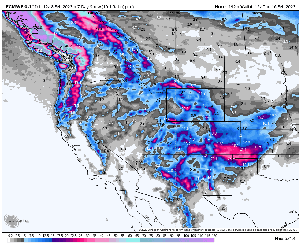
Then from Monday through Wednesday, a chilly N-NW flow will see snowfalls march southwards over the U.S. with the central and southern Rockies copping a decent load from late Tuesday as a low over the southern US throws its hat into the mix.
Thursday Feb 9th & Friday 10th
Light snowfall over the eastern portion of the central and southern Rockies will eventually clear out Thursday, leaving behind a nice dusting of about 5-15cm, as a large high-pressure system migrates southeastwards, bringing sunshine and happiness with it.
Beyond the reaches of the high, a mild, humid southerly flow will see mixed precip spread down from the Canadian Coastal Mountains into the Cascades Thursday night, and eventually into the Sierras late Friday as the winds become colder from the northerly quarter.
During this time, the northern Canadian Rockies will also cop a heavy load of snow, with just a light dusting reaching further south into inland BC.
Saturday Feb 11th & Sunday 12th
High pressure and fine settled weather will remain ensconced over much of the US this weekend. Any snow left over in the Sierras will clear out Saturday morning.
Light snowfall over Canada will ramp up during Sunday as a fresh wave of cold westerly winds blow in from the Pacific, with snow levels dropping and snow quality improving. This snowfall will eventually filter down into the Cascades and northern Idaho/Montana during the second half of Sunday.
Monday Feb 13th to Wednesday 15th
The high over the US will become squeezed into oblivion during this time between a low over the far south and an encroaching flow coming out of the N-NW.
The southern states will briefly see snow falling on Monday, while light-moderate snowfall over Canada and the Cascades continues to spread southwards, where it eventually moves into the central and southern Rockies during Tuesday after having passed over the northern Rockies and Sierras.
As the snow marches south, a low forms over the southern U.S., which will see to it that the central and southern Rockies cop a fairly heavy load of powder during Wednesday.
Next Thursday Feb 16th & Beyond
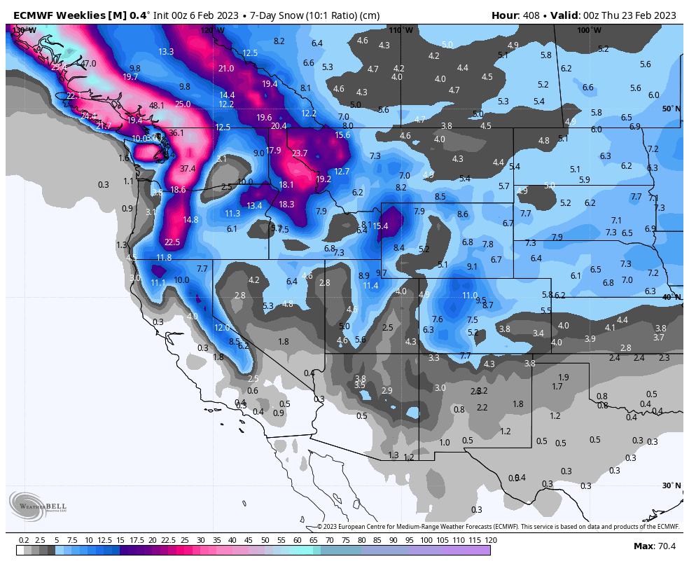
High pressure looks to dominate much of the US again through into next weekend, while a system pushes from the W-NW, with snowfalls likely benefiting the Pacific Crest and northern Rockies the most. From then onwards, weather system look to primarily favour the north.
Well, that’s all from me guys and gals, see you next week.


