New Zealand Forecast, Monday September 16th – Deep Powder in the Southern Lakes, More Snow for All Kiwi Resorts

Mountainwatch | The Grasshopper
After receiving 20-30cm at base levels and 50-60cm up top late last week, the Southern Lakes scored another 20-30cm after snow fell on Sunday. Canterbury only picked up a dusting on top of that 15-20cm they scored on Friday. Today (Monday) will be yet another “best day of the season” kind of days with the weather also lining up.
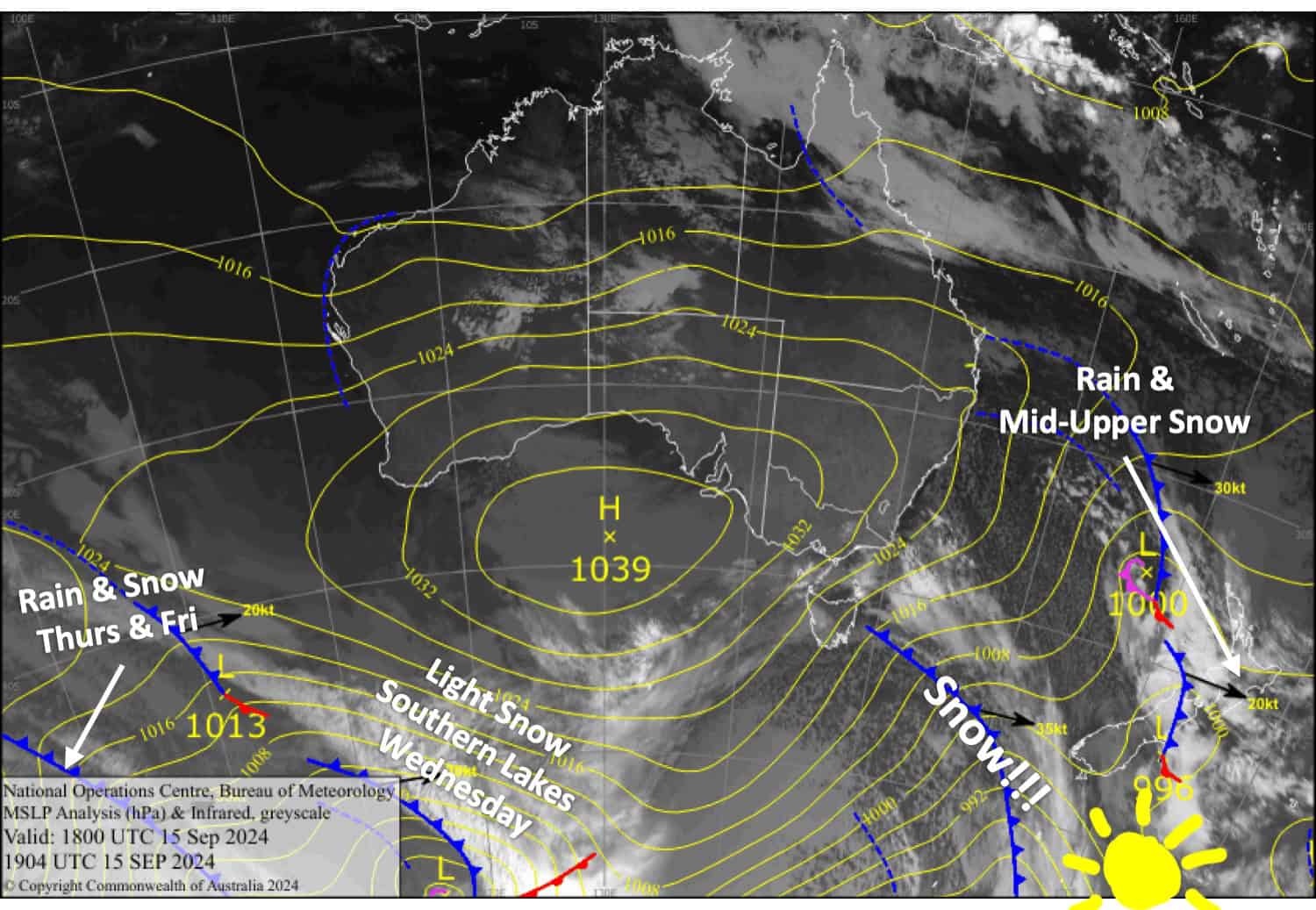
As if that weren’t enough, a strong southerly change will bring an extra 5-10cm top-up to all South Island resorts Monday evening into early Tuesday. There’ll be more light snow showers over the Southern Lakes on Wednesday before another front dumps a load of rain and snow across the South Island late Thursday.
After some mid-high level snow today, Mt Ruapehu will receive 10-25cm below base levels on Tuesday. It’ll be the first decent load of snow there in a long while, and it will be greatly appreciated.

Monday September 16th
Cloud over the South Island breaks up this morning for a mostly fine day while northwest breezes develop. However, Mt Hutt may see light snow flurries until around midday. A strong southerly change hits the Southern Lakes in the evening and Canterbury overnight, bringing a top-up of around 5-10cm.
Rain sets in over Mt Ruapehu in the afternoon, falling as snow on mid- and upper slopes. It’ll pin back to light snow showers to below base levels in the evening as northwest winds turn to a colder southwest.
Tuesday September 17th
Remaining snow showers over the South Island gradually clear, and fine breaks develop as southwesterly winds ease.
Snow day for Mt Ruapehu with heavy falls likely in the afternoon as southwest winds change to a strong, cold southerly. Snow clears at night
Wednesday September 18th
A cloudy day for the Southern Lakes with light snow showers from late afternoon and northwesterly winds. Skies become cloudy over Canterbury in the morning as northwesterlies strengthen.
A clear start for Mt Ruapehu, but cloud and light snow showers arrive from late morning as brisk southwesterlies turn westwards.
Thursday September 19th
Cloudy for the Southern Lakes, with a few snow showers becoming heavy and persistent for a time late afternoon and evening as gusty northwetserlies turn westerly. However, the snow may fall as rain on the lower slopes due to warming temperatures.
In Canterbury, strong northwest winds will blow a gale in exposed areas, forcing showers of rain and mid- to high-level snow over the Main Divide. These showers will become heavier and more persistent in the evening. However, Mt Hutt will stay dry until about late afternoon, when a little bit of rain will also reach the frontal range.
Snow showers on Mt Ruapehu will turn wet at mid- and low elevations in the morning as temperatures warm. Westerly winds will strengthen.
Extended Forecast
Another front is likely to bring another top-up to the South Island during the latter half of Friday, while rain and high-level snow continues to fall on Mt Ruapehu. Conditions will be rough with strong-gale northwesterly winds.
Another weather system is likely to affect the country this weekend, however, models are still uncertain about what shape or form this will take. Snowfall over the South Island will likely turn wet as warmer northerlies arrive, while things should clear up over Mt Ruapehu.
That’s all from me today, folks. The next forecast is Wednesday. See you then, and have a couple of days.
Grasshopper


