Grasshopper’s 2026 New Zealand Snow Season Outlook – El Niño to Favour South Island
Mountainwatch | The Grasshopper
Summer has been and gone and now we move into May, one step closer to the 2026 Winter Season. Coming off a La Niña event peaking over the summer, and mostly neutral conditions with an inconsistent year for ski fields last season we’ll dive into what to expect for 2026.
El Nino on the way
If you have been following along at home, you might have noticed talk of a “formidable” El Niño event shaping up for this year. After La Niña conditions eased at the end of the summer ENSO is now firmly neutral with global climate models agreeing on the development of warmer waters in the equatorial Pacific through the remainder of the year.
Importantly, ENSO is said to account for approximately a quarter of the seasonal variation in temperature and precipitation over New Zealand, so it is not the only force at play, but it does have a significant impact. In past El Niños during our winter – think 2023 and 2015 – El Niño can push a lot of fronts over NZ, particularly the South Island, with cold S-SW winds often dominating. Throw moisture into those fronts and we should see some snow.
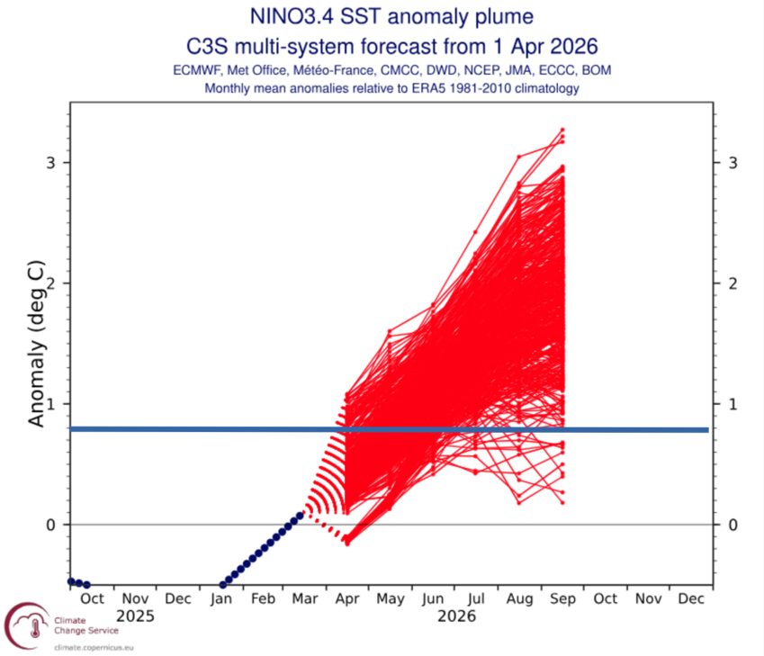
Below is an ensemble plot of the Nino3.4 index, showing the SST in a specific region of the equatorial Pacific widely used as a proxy for ENSO classification. We can see a clear positive trend in values moving through the year, I’ve placed a line at 0.8°C, the threshold used by the Bureau of Meteorology for an event.
Looking broadly, we can see majority of ensemble members above that threshold after the June/July period, with some significantly above this level. An interesting caveat of those more extreme values is that the SST anomaly itself and the impacts of an ENSO event are not a perfect linear relation, in that a strong SST anomaly may not always induce stronger impacts in the global circulation when compared to a weaker anomaly.
Under Pressure
The main mechanism that ENSO uses to exert its impact on New Zealand is through a tendency of anomalously higher pressure over Australia (think blocking highs), which act to drive a consistent south-westerly airstream over NZ. As we move through the next few months, we will see the La Niña/neutral ENSO influence weaken and expect things move towards an El Niño like pattern.
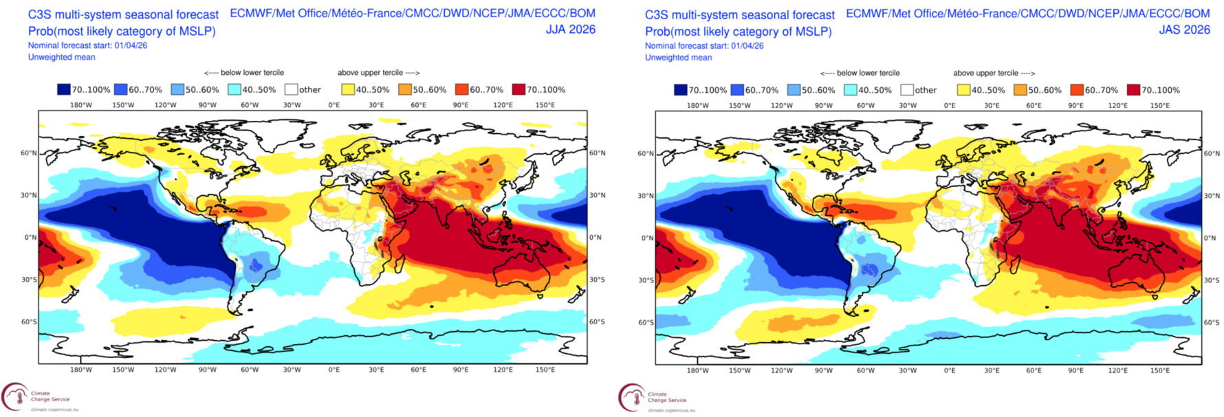
Below is a forecast of the MSLP (Mean Sea Level Pressure) for the June-July-August period (left) and July-August-September period (right). The broadscale pattern shows broad areas of higher-than-normal pressure over Australia, while low pressure sits to the south/southeast. Scanning across from the June-August period to the July-September we can see these areas of anomalous pressure further intensify.
This El Nino pattern favours the southwest of NZ but often leaves the northern and eastern areas begging. This year the potential for a positive IOD event helps amplify this pattern further promoting blocking highs over the Australian mainland.
Seasonal Products
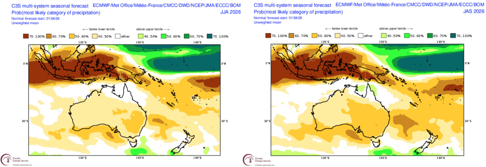
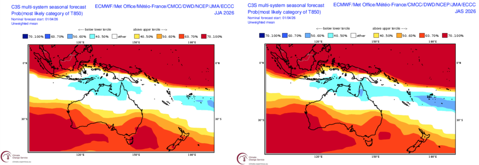
So, what do we get when we put everything together? Over the next few months things will transition to more of an El Niño pattern. Below we have three monthly forecasts of precipitation and 850hPa temperature (roughly around the 1500m elevation mark), we can see the patterns over winter aren’t too surprising considering what we already know.
Focusing on precipitation, with fronts pushed southwards below the Australian continent and the south-westerly airflow promoted over NZ we see neutral to above average precipitation forecasts for areas of the South Island. As we look north things gradually dry up with a below average signal for much of the North Island.
When looking at potential temperature, the below charts show the most likely forecast for the 850hPa level (roughly 1500m elevation). The problem is broad areas of higher-than-average temperatures are expected across NZ with little variation moving through the snow season.
Wrapping it up
Overall, the story of the moment is the high likelihood of an El Niño event developing over the remainder of the year, having a noticeable impact on the NZ snow season. Forecasts are not favouring the North Island with the promotion of a south-westerly airflow mainly helping areas of the South Island, particularly the southwest, with above average precipitation.
However, warmer temperatures may act to stifle some of the helpful impacts with the broad areas of above average temperatures possible across the country. Remember this is an average over a three- month period and in a New Zealand winter, it’s all a matter of one or two degrees. As in the past, the southwest fronts will drag up colder air as they cross, leaving some snow in their wake.
Stay tuned this season as we update the seasonal outlook each month with the latest information and my regular NZ forecasts will start in early June.