New Zealand Weekend Forecast, Friday, September 25th – Another Freshen-Up Friday, Then a Bigger Powder Dump Sunday
Mountainwatch | The Grasshopper
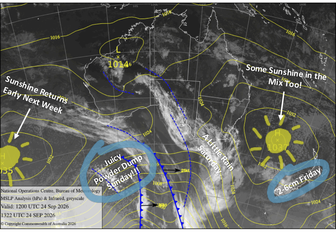
The spring powder taps keep dribbling, with Mt Hutt scoring 10cm Tuesday night and Mt Ruapehu 5cm on Wednesday, topped off with great snowmaking conditions. Another weak system adds to the tally today, Friday, with a handy 2-6cm expected across South Island and Mt Ruapehu ski fields.
The real action arrives this weekend. Saturday brings a brief lull before an icy southerly blasts up the South Island early Sunday, potentially dumping 5-15+cm across the Southern Lakes and 10-30cm in Canterbury. Mt Ruapehu gets its share later Sunday, although severe gales and heavy rain beforehand will make for a pretty atrocious day.
A few more snow flurries linger into Monday before conditions come right across the country on Tuesday.
Friday 25th September
Light snowfall clears the Southern Lakes early in the morning while spreading north over Canterbury as a weak system slinks up the country. Cloud then gradually breaks apart over the Southern Lakes, opening the door to a cracking sunny afternoon with light westerly breezes. Snow over Canterbury also gradually clears through the latter half of the day. All up, South Island ski fields should pick up a handy 2-6cm of fresh powder from this weak system.
Mt Ruapehu starts out fine, but light snow showers develop later in the morning as southwesterly winds pick up, giving the ski fields a dusting of up to around 6cm.
Saturday 26th September
A weak front brushes across the South Island early, bringing little more than a spot of rain before leaving behind partly cloudy skies and a stiff northwester.
Conditions deteriorate on Mt Ruapehu as southwest winds strengthen. Clouds build during the morning before rain and high-level snow set in around midday. Precipitation turns to rain at all levels during the evening as winds swing around to the northwest.
Sunday 27th September
An icy southerly front blasts up the South Island early in the morning, reaching Mt Hutt around dawn and dumping fresh powder to low levels. Snow gradually backs off to lighter showers from the south before eventually clearing during the afternoon as winds ease and swing southwest.
Conditions will be atrocious on Mt Ruapehu, with rain becoming heavy as northwesterlies start howling and severe gales up high likely keep the ski fields closed. The cold southwest change hits around late afternoon, flipping rain to snow before things finally start settling down during the evening.
All up, this system could lay down around 5-15+ cm for the Southern Lakes and Mt Ruapehu, and 10-30cm for Canterbury, delivering another timely late-season boost.
Monday 28th September
A strong, chilly southwesterly keeps skies mostly cloudy over the Southern Lakes, along with a few lingering snow flurries.
Canterbury fares better, with mostly sunny skies and brisk westerlies.
Mt Ruapehu gets another fine start, but snow showers redevelop during the morning as brisk, cold southwesterlies kick in.
Tuesday 29th September
Conditions improve across the country as southwesterly winds ease. Cloud clears the Southern Lakes for a mint afternoon, while Canterbury enjoys a sunny day. Mt Ruapehu also comes right as lingering cloud and snow flurries gradually clear.
Extended Forecast
After a brief breather around Wednesday the 30th of September and Thursday the 1st of October, a couple of weak storm systems are expected to make landfall later in the week. Models are still wrestling over the details, but the Southern Lakes currently look most likely to cop the bulk of the weather, although little to no snow is expected.
That’s all from me today, folks. I’m sending out NZ forecasts every Monday, Wednesday and Friday throughout the season. Have a great weekend, and I’ll see you back here on Monday.
Grasshopper