New Zealand Weekly Forecast, Monday August 22 – After a Week Of Spring Conditions Winter Makes a Comeback This Week
Mountainwatch | The Grasshopper
Valid Monday, August 22nd to Sunday, August 28
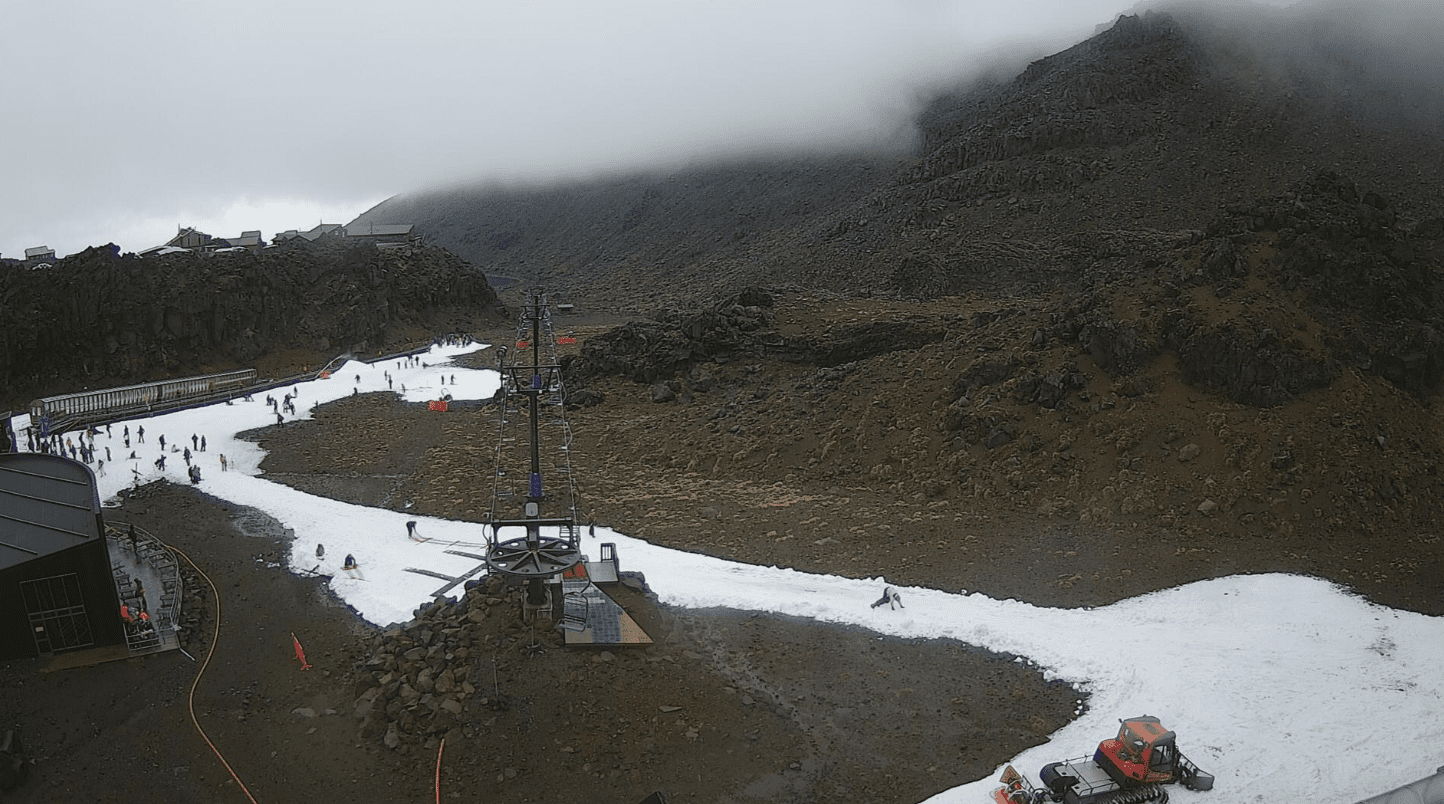
Spring-time conditions were observed last week as intense rainfall combined withnear-record temperatures, both day and night, across the country. This had a major impacton the snow bases at the ski fields, most notable at Ruapehu and the Upper South Island fields like Hanmer, where the snow pack was rendered unusable.
This week sees another pattern shift, with a colder air mass returning and spreading northwards over New Zealand through the week, although snowfalltotals are unlikely to make up for last week’s degradation in the snow pack. A cold front brings minor snow and strong northwesterlies to the Remarkables and surrounding fields from late Tuesday into Wednesday, but the bigger weather maker will approach mid-week from the northwest in the form of a Tasman low (yes another one!).
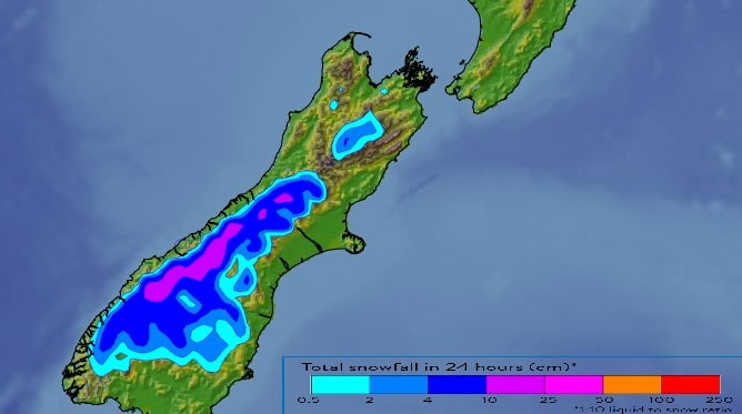
However, this one is slightly differentand while precipitation initially starts as rain, a trailing strong southerly change drags up colder air across the South Island on Thursday, with freezing levels falling to levels not seen over the past week, around 800 metres. This should bring much-needed snow to refresh the dwindling bases across South Island fields from Mount Hutt southwards. Most weather models are keeping snow accumulations on the lower-end, but some of the outliers do have higher accumulations, and this will be the system to watch.
The cold air then shifts northwards across northern South Island and potentially Ruapehu during Friday, while moving away from central and southern South Island. While this could bring a small top-up to Hanmer and Ruapehu, snow accumulations are unlikely to produce enough to make up for last week.
High pressure moves onto the South Island from Friday through the weekend. Southerly winds will gradually ease during Friday, and bluebird days are looking likely from Friday to Sunday.
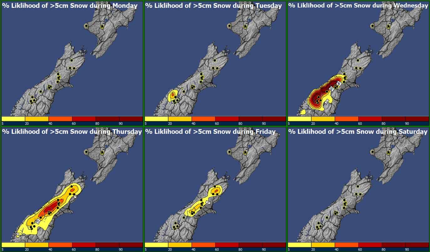
Tuesday 23rd– Wednesday 24thAugust
A cold front moves up southern and central South Island, with strong northwesterlies ahead of the feature. Rain initially, turning to snow showers south of Mount Hutt, with snow accumulations most likely remaining below 10cm. Fine elsewhere.
Thursday 25thAugust
Warmer conditions bring periods of rain across South Island fields at first, turning to snowy showers as southerlies bring lowering freezing levels. The snow is relatively short-lived, but accumulations exceeding 10cm are possible for the Remarkables and Mount Hutt, with lesser amounts for Hanmer. Strong and gusty southerlies.
Friday 26thAugust
Improving conditions across central and southern ski fields, both for clearing skies and easing winds, with the potential for a bluebird day. Snow showers stick around for Hanmer and spread up to Ruapehu, with minor accumulations likely, though much cooler conditions are expected with the potential for snow making.
Saturday 27th– Sunday 28thAugust
High pressure brings mint weather across the board, with the potential for Bluebird days, especially about and south of Mount Hutt. Further north, a lingering southeasterly flow could bring in the odd shower and cloud cover, with temperatures hovering on the rain/snow border.
Extended Outlook
No change in the weather pattern on Monday, then a weak cold front approaches the Remarkables on Tuesday with strengthening northwesterlies and brief rain possible ahead of the feature. However, high pressure remains in charge through mid-week and could force the cold front back southwards with a return to mint skiing conditions.


