North America 2021-22 Snow Season Outlook
Mountainwatch | The Grasshopper
The season started off with a bang in October with unseasonably large totals over western North America, however since then things have quietened down a bit, particularly in the US.
Some resorts in Canada are open with great early conditions after some good November falls and more snow on the way this week, but it is a different story for areas south of the border with some resorts having to delay openings. It is obviously still quite early in the season and I’m going to unpack what to expect for winter, maybe give you some motivation for a last-minute North American getaway.
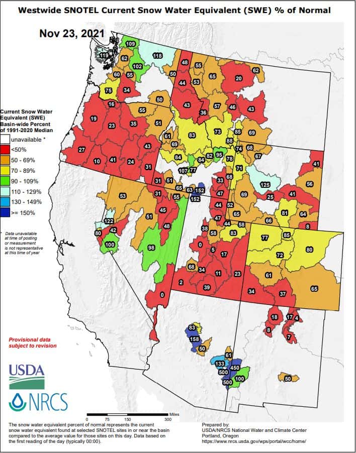
The slow start is pictured below showing the percentage of median depths around western USA. Red areas show snow depths that are under 50% of the median value at that location for this time of year. It is early and so as much as these colours aren’t ideal there is reason for some regions to keep their head up, especially in the northwest.
La Nina Returns
Over the past few months you might have heard rumblings about a second La Nina winter in a row (see my Japan Seasonal Outlook) and it has been confirmed recently by the BOM and is going to grace the Northern Hemisphere. A La Nina can mean good or bad news in North America – depending on where you look as unlike Australia ENSO phases are not as easy- El Nino (usually bad), La Nina (usually good).
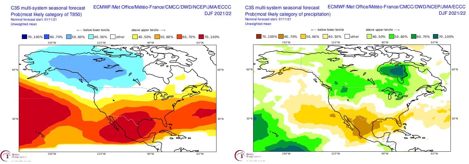
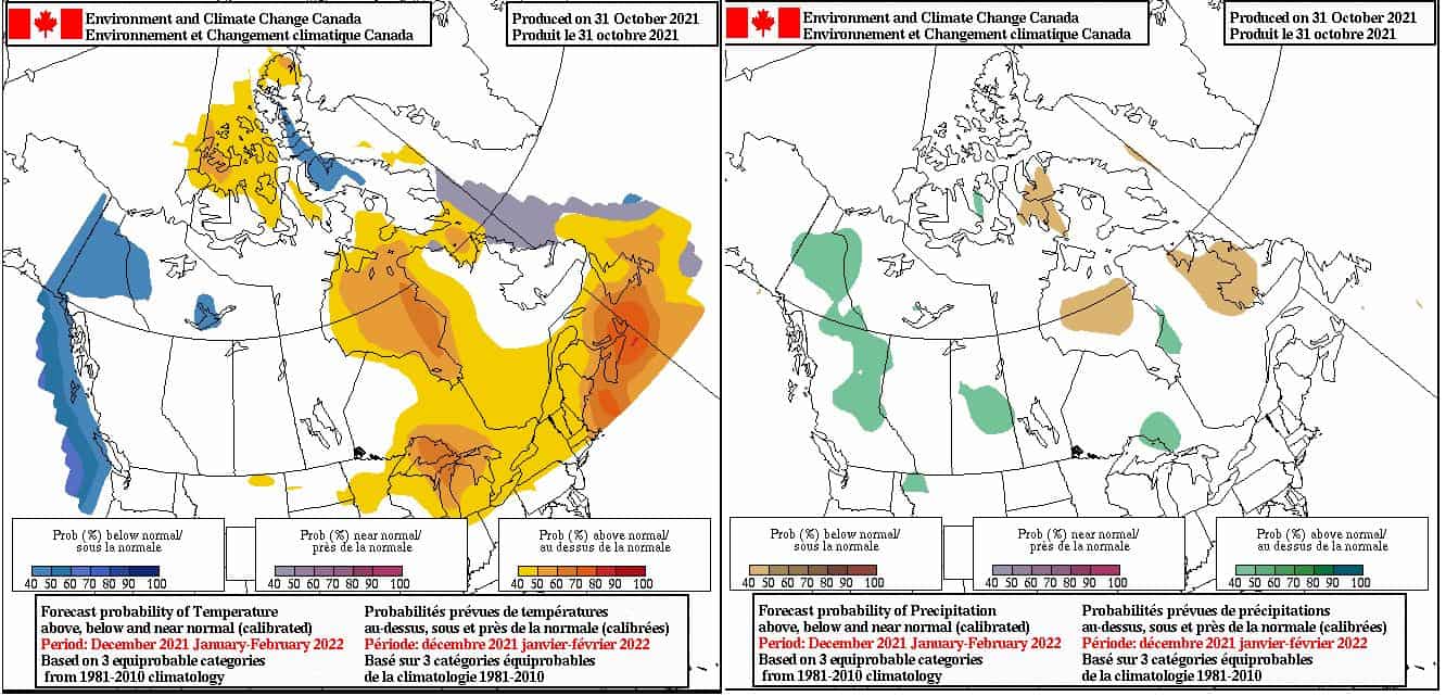
Typically, during La Nina phases in North America, the northwestern areas fair best, including the PNW, Canadian Rockies, Coast Mountains etc. For areas further south, it tends to be not great news, with warmer and drier conditions more likely. This pattern is visible in the two seasonal outlooks below which represent the mean from eight different meteorological agencies around the world. The left plot shows forecasted temperature anomalies and the right has precipitation anomalies for the upcoming winter. We can see areas in the northwest are most likely to have the best results this season, with areas further south looking a little warmer and drier.
More Seasonal Forecasts
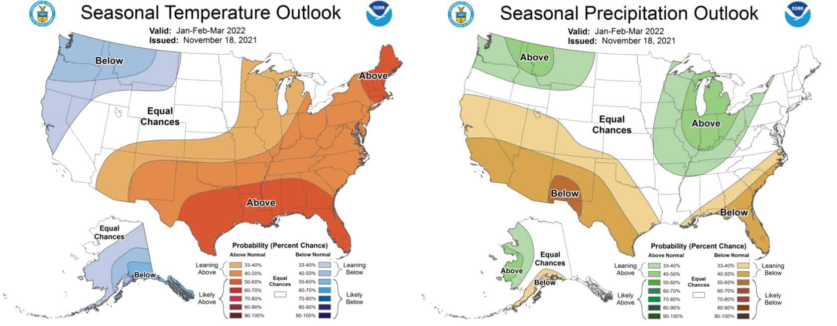
The general idea of the plots above is repeated in the NOAA and Environment Canada forecasts for the upcoming winter. We can see the same pattern favouring areas around the Pacific Northwest and western Canada with average outlooks for the American Rockies and the Tetons.
2020 Sequel?
Looking at all the figures above you could easily confuse the upcoming seasonal outputs for last year’s with the double dip La Nina on the horizon dominating seasonal predictions. As the weather is a chaotic and an inherently unpredictable beast I’m not saying we are going to experience a pure repeat of last year but the settings are in a very similar position right now, so it will be interesting to see how it plays out. Last year also had a slow start but turned out to provide some excellent conditions through similar areas outlined here.
Conclusion
Overall, it’s looking like average to above average season in store for the northwest of the USA and Canadian Rockies. It is pointing toward average conditions through the American Rockies and Tetons and an average to slightly below average for Utah and the Sierras. Basically, the further south into America you go the prediction is for higher temperatures and less precipitation. Last year saw some big storms throughout many of the Western ski areas as it’s important to remember average in some of these places is world class. Once again seasonal predictions are rough, but do give a good little insight as to where to look for some of the biggest storms throughout the upcoming winter.
That’s it from me folks. If you’ve got a different theory on what’s going to happen this winter, or just want to provide feedback, then please hit me up on the discussion below. Or you can follow me on Facebook. Remember to check out my weekly forecasts for both Japan and North America starting mid-December, giving you all the highlights and snowlights of the coming weeks.


