SNOW SEASON OUTLOOK JAPAN – The Usual Powdermonium Expected
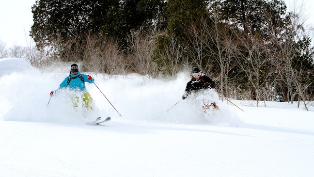
Steve Lee and daughter Layla skiing Hakuba’s famous powder in March 2011. Image:: Chris Hocking
Season Outlooks | The Grasshopper
Here we go then. Australian and New Zealand ski resorts are firmly locked in a spring cycle, and our thoughts are starting to drift northwards. Whether you prefer the cultural delights of Japan or the charm and convenience of North American resorts, the talk, as always, is turning towards what sort of season we can expect in the Northern Hemisphere.
In this piece we’re going to look at Japan – specifically Niseko on the island of Hokkaido and hakuba on Honshu – and try to extract every last clue about what pleasures and pitfalls the northern winter might hold.
A weak little girl
One frequent topic of discussion whenever Japan snowfall comes up is what the El Nino Southern Oscillation (ENSO) is up to. We’re expecting a weak-to-moderate La Nina event this year, and given ENSO is the world’s biggest driver of climate, it’s natural to wonder what effect it might have on Japan’s snowfall.
La Nina certainly does affect the climate across East Asia. We know, for instance, that atmospheric pressures tend to be stronger to the north of Japan, slightly below average over Japan, and below average south of Japan.
The consequence of this is that winds have a more northerly component. Temperatures also tend to be about half a degree colder than average over most of the country (Figure 1), and there is a weak signal for more precipitation than normal during La Ninas (Figure 2).
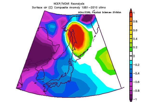
Figure 1: Temperature anomalies during La Nina years
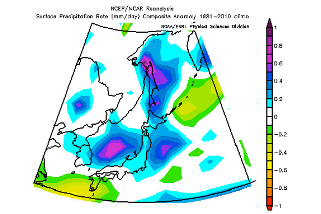
Figure 2: Precipitation anomalies during La Nina years
Uncertain fruits
Colder than normal eh? With more precipitation? That’s gotta mean more snowfall right? Let’s see.
From the 1953/54 season until 2010/11, Kutchan, near Niseko, averaged 1199cm of snow from November to March. But get this: La Nina years over the same period averaged only 1167cm. And strong La Nina years averaged even less, at 1062cm. So it’s not surprising that 2010/11’s strong La Nina came in with 1004cm of snow, about one sixth less than normal.
When we move further south to look at Toyama and Takada (on the coast near hakuba), we see a slightly different story, with La Nina years and neutral years both slightly above average (and El Nino years about 20 per cent below average).
I think the reason we’re not seeing a clear signal for the additional snowfall that we might expect in La Nina years comes down to the very complex mechanism that generates such fantastic snowfall for Japanese ski resorts in the first place.
Take a walk down snow street
I’m talking of course, about the “lake effect”. Or in this case, the “Sea of Japan effect”. The average wind during winter is a north-westerly that is driven by a massive high pressure system that forms over Siberia during winter. As this air comes off the Asian continent it is incredibly cold and dry.
So when it travels over the relatively warmer Sea of Japan the air near the surface picks up a lot of moisture and is warmed considerably.
The air, now warmer , is less dense than the air above it, so it rises, transporting moisture into the lower levels of the atmosphere. This cold, moist air then slams into the mountain ranges, rises rapidly, and pukes all that moisture out as snow.
As the air travels across the Sea of Japan it also tends to organise itself into bands of convection, called cloud streets. These “streets” may only be a few kilometres or tens of kilometres wide, which explains the fickle nature of snow in Japan. In any single event a mountain just down the range can be getting dumped on and you could miss out.
A thousand words
The image below is a favourite of mine. It shows the organised nature of these streets. But to get this situation we need to get a bit goldilocks on it, with everything “just right”.
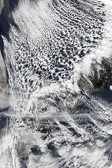
Figure 3: Cloud streets over the Sea of Japan
First, we need the air to be significantly colder than the sea surface, so we get the instability necessary for the convection that will mix our moisture through the atmosphere. Second, we need a long body of water so the air has time to pick up the moisture. Third, we need an inversion at about three kilometres up in the atmosphere, which keeps a lid on the convection and keeps the moisture close to the earth. Lastly, you need the wind to be a fairly steady speed and direction all the way up to the inversion; otherwise it will mess up all of your lovely organised cloud.
It turns out that the situation where cold dry north-westerly winds pass over the Sea of Japan for 250 to 500 kilometres before reaching Japan is very good at producing lake effect snow. But you’d probably be talking several years of research to come up with an explanation of how the changes caused by La Nina might affect the delicate balance that gives us the take effect.
You might also see some brave souls out there talk about other climate factors, such as the arctic oscillation, or the Pacific Decadal Oscillation. I won’t go into what these are now because for starters, we’re not very good at forecasting these indicators months in advance, so they’re kind of useless for seasonal forecasting. In addition, even if we could forecast them, we’d be in the same situation of not really knowing what they do to the lake effect without years of search.
It’s a sure bet
Put a gun to my head, and I’d say that this year we’ll see about five per cent less snowfall than average for Niseko resorts, and about five to ten per cent more snowfall than average for hakuba resorts. That’s just playing the averages, but in reality we could still see well above or below average snowfall in either area.
But the more important thing to consider is just how reliable snowfall is, especially around Niseko. For example, about 95 per cent of years since 1953/54 at Kutchan have recorded more than 8 metres of snowfall.
Things are a bit more variable down Honshu way. Takada, for example, with an average snowfall of 617cm from November to March, records at least 3 metres of snow about 90 per cent of the time.
Up around hakuba itself, which boasts around 11 metres of snow a year (although I can’t find the records to back that up), I’d expect they’d be seeing at least 6 metres of snow about 90 per cent of the time.
Unless you’ve done so many snow seasons in Japan that you’re starting to get jaded and picky about six to eight metres of snow, you really can’t lose by booking a holiday in Niseko or hakuba this winter.
So that’s the land of the rising sun. Watch out for my outlook for Canada in the next few days and remember that from November you can catch my thrice-weekly snow forecasts for key resort areas in Japan, Canada and the US. Through the Aussie summer, you’ll always know when you’re missing out on spectacular Northern Hemisphere powder.
That’s all from the Grasshopper. Got a question or feedback for me? Hit me up at:
grasshoppermw@gmail.com – twitter, or facebook
Hakuba forecasts,
snow reports and
live snow cams.
Niseko forecasts,
snow reports and
live snow cams.


