Snow Storm Journal – Australia Sept 26 and 27, 2009
Was this the storm of the season?

What a difference a few days can make.
It is debatable if it was the storm of the season, but there is definitely no doubt that it was the storm of the 2009 spring.
It came while most of us were busy watching the Northwesterly “blow-drier” winds bringing snow-melting temps, heavy rain and red dust storms to the Australian Mountains – just when we all thought the season was coming to a crashing halt, mother nature took us in her hands and laid us down in over half a metre of fresh dry snow. And as some people have named it – the snow storm of the year.
.jpg)
Mac Taylor hiking for the goods at Falls Creek where they enjoyed 42cms of fresh powder. Photo: Chris Hocking
.jpg)
Mac Taylor skiing the uncrowded tree runs of Falls Creek. Photo: Chris Hocking
.jpg)
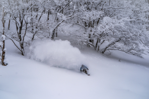
Mac Taylor Laying them deep at Falls Creek. Photo: Chris Hocking

There was enough snow from this storm that cliffs and drops were back on the agenda for a day of skiing. Mac Taylor Falls Creek. Photo: Chris Hocking
5 Reasons why this was the snow storm of the year:
1. From Zero To Hero: The storm took some resorts from pending closure to extend the season by another week and a half. EG Mt Buller.
2. No crowds: Most good snow storms and powder days are in the busy months of July and August. The mountains were pretty much empty as all the punters were busy trying to swim in the ocean and imagine it was warmer than 17 degrees. This left all the pow and lines for the locals and the die hard committed. At one stage the Mountainwatch team was lapping Thredbo’s Kosciuszko chair with no more than 15 people on the mountain.
3. Wet base snow to cold and dry: With so much exposed rocks and grass from the spring melt the storm started with a night of heavier wet snow which gave a protective base that packed in all those holes and rocks, by the next morning it was snowing cold and dry leaving a fresh “blower” top layer to ski and board.
4. Limited Lifts Open: With resorts shutting down lifts across the mountain due to lack of punters, it made access to the good stash’s of snow less obvious. The people in the know scored deep fresh runs where if it was August or July it would have been tracked by 10am.
5. Cheap Lift Tickets: Not only cheap tickets but cheap accommodation and more good deals than the new Costco in Melbourne.
6. (Yep a 6th) The wind on Sunday 27th: Increasing wind on Sunday meant every run the fresh powder was blown back into your track and it sent most people off the hill early. The best turns were scored that Sunday afternoon.
Steve Lee hooking a turn out of the bottom of Stanley’s at Thredbo. Usually tracked by 10am, it was totally fresh at 2:30pm on Saturday the 27th. Photo: Russell Holt
Wind blown snow meant fresh tracks for most of the day. This was midday at Thredbo under the Kosciuszko Chair. Photo: Russell Holt

Amanda Ellis enjoying the fresh above Sponars T-bar at Thredbo on the first bluebird day after the storm. Photo: Reggae Ellis
Snow storm depth totals for each resort (25th – 28th Sep):
NSW
Charlotte Pass 55cm
Thredbo 53cm
Perisher 61cm
Selwyn Snow Fields 35cm
VIC
Falls Creek 42cm
Hotham 46cm
Mount Baw Baw 43cm
Mount Buller 49cm
Australian Resort Closing dates for 2009:
Hotham – Closed
Falls Creek – October 4
Mount Buller – October 4
Mount Baw Baw – Closed
Thredbo – October 5
Perisher – October 4
Charlotte Pass – Closed
Selwyn Snowfields – Closed
New Zealand snow resort closing dates:
Treble Cone – October 4
Cardrona – October 4
Snow Park – October 4
Coronet Peak – October 4
Remarkables – Oct 11
Mt Hutt – October 18
Mt Ruapehu (Both Whakapapa & Turoa ) – October 18
Video From Falls Creek where they received nearly 70cms of snow over the weekend.


