The Grasshopper’s Weekly Japan Forecast – Good Snowfalls Saturday, Warm Temps and Rain Tuesday and Wednesday
Mountainwatch | The Grasshopper
Thursday 14thFebruary (Japan time)
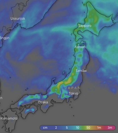
Ten-day totals this week should lie in the range of 25-45cm for most resorts, with up to 60cm on more exposed terrain of central Honshu. Most of this will fall during a good dump on Saturday, with just snow showers or flurries interspersed with sunshine on other days. However, temps will skyrocket on Tuesday as winds turn to the south and a low will bring another one of those ghastly rain/wet snow events. Fortunately, freezing northerlies will again sweep over Japan in the wake of the low late Wednesday, with fresh snowfalls undoing the damage and giving us some respite before another potentially ominous system lines up from next Friday.
Thursday 14 Feb:
There is a steady stream of snow showers flying in on freezing N-NW winds. Winds and snowfalls will gradually ease over Honshu as a ridge builds.
Friday 15 Feb:
A high crosses over Honshu with mostly cloudy and calm conditions, while snow flurries on Hokkaido eventually peter out as NW winds swing around to the west.
Saturday 16 Feb:
A low in the Sea of Japan crosses the Tsugaru Strait between Honshu and Hokkaido, kicking off moderate-heavy snowfalls over Honshu as well as heralding in colder W-NW winds, which will blow a gale over the northern part of the island. Hokkaido will also receive a nice dusting during the morning and winds will be much lighter.
Sunday 17 Feb:
Snow flurries will come down throughout the day as NW winds continue. There’ll be more falling on Honshu, but a trough brushes Hokkaido at night and will drop a nice, tidy top-up on resorts there.
Monday 18 Feb:
The same trough will give Honshu a glancing blow with a nice dusting falling on northern parts before dawn. Any remaining flurries will clear during the morning as a high drifts onto Honshu, then we’ll see more and more sunshine through the afternoon.
Tuesday 19 Feb:
The high will drift out into the Pacific and winds will turn to the south as temperatures become positively balmy. The day will start out fine with just a bit of high cloud coming off a low that will be brewing up in the Yellow Sea. This same low will spread rainfall up Honshu during the latter half of the day as it wanders into the Sea of Japan, with wet slushy stuff falling on Hokkaido.
Wednesday 20 Feb:
The low deepens as it passes over Japan to ravage the North Pacific. Heavy rain will gradually ease over Honshu, and then turn to snow at night as cold N-NW winds hit. It’ll be a similar story for Hokkaido where wet slushy snow will turn to the lighter fluffier variety late in the day as freezing northerlies hit.
Extended Outlook:
We should have decent snowfalls into the early hours of next Thursday before high pressure builds and eases off those precious N-NW winds. After that, it doesn’t look like any real snowfalls are on the cards and we’re likely to see a warm system from the Yellow or East China Seas bring a rain event to south and central Honshu.