The Grasshopper’s Weekly North American Forecast – Plenty going on with plenty of Snow for everyone
Mountainwatch | The Grasshopper
Wednesday 16thof January (Pacific time)
It’s a fairly stormy week ahead with lots going on; some days almost turned into an essay. Again, the Sierras stick out with ten-day accumulations up over the metre mark, but about half of that will fall in the next 24 hours during the current storm. The Rockies are also looking good with accumulations getting up around 50cm-75cm in a lot of places with fairly consistent falls on the cards. The Coast Mountains and Cascades will have a large chunk of their accumulations come down over the next few days, but there should be enough thereafter to keep the slopes fresh and fruity.
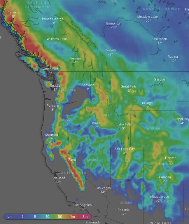
Snowfalls are more evenly spread in this week’s ten-day snow accumulation chart with plenty for everyone. Source: windy.com
Thursday 17 Jan:
A low, sitting just off the west coast, trundles northwards without making landfall. However, it pushes in moisture laden S-SW winds over the Sierras, Cascades and the Coast Mountains of Canada. It’ll be a full-on blizzard in the Sierras with heavy falls, but it will ease in the evening as it gets heavier over the Coast Mountains. There’ll be good snowfalls over the Canadian Rockies and those of Montana and Idaho where the moisture meets much colder air. A low also flares up over the High Plains, ensuring decent snowfalls spread east over Utah, Wyoming and Colorado.
Friday 18 Jan:
Snow falling throughout the length of the Rockies will gradually ease as the low over the High Plains meanders eastwards. Snowfalls over the Coast Mountains will ease, but return again late in the day with renewed vigour as a second low in the Pacific follows a similar path to the previous one, while also ravaging the Cascades. The Sierras will see snow showers, mostly in the morning and evening.
Saturday 19 Jan:
As the second low in the Pacific makes its way towards the Gulf of Alaska, moisture laden S-SW winds drop moderate to heavy snowfalls over the Cascades, the mountains of Idaho and Montana, as well as over Canadian resorts where it’ll ease later in the day. High pressure further south over the Rockies will restrict things to just flurries late in the day.
Sunday 20 Jan:
A westerly airstream coming off the Pacific will bring more snow to the Cascades, the northern Sierras and the Rockies of Idaho and Montana. Snowfalls will then spread over the southern Sierras and southern placed Canadian resorts during the latter half of the day as a deepening low makes its way inland.
Monday 21 Jan:
The low will slowly drift over the High Plains, drawing in chilly northerlies and decent snowfalls across the American Rockies. Remaining snowfalls along the Pacific Crest will dwindle, and a front will get snowfalls going over the Coast Mountains of Canada later.
Tuesday 22 Jan:
Another westerly airstream will bring moderate snowfalls to Canadian resorts, while high pressure further south clears any remaining snowfalls over the American Rockies.
Wednesday 23 Jan:
A cold northerly airstream should spread light to moderate snowfalls from the Canadian Rockies down to at least Wyoming and possibly Colorado.
Extended Outlook:
Next Thursday and Friday should see high pressure build over western North America, reducing snowfalls to just flurries here and there over the Rockies. It’s very much up in the air what will happen after that, but the high pressure looks like a big, slow moving oaf, so we may have to wait until after next weekend before things get going again.


