WEATHER ANALYSIS – The Unstoppable Advance of Spring
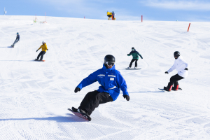
Spring conditions at Mt Buller dictated the direction of the SoO AirTime video edit event. Here, competitors make the most of what they have to produce some creative imagery. Image:: Joey Corcoran
Weather Analysis | The Grasshopper
Ahh spring… For most people it signifies a period of renewal and new life. But for those of us that live for the snow, it’s possibly the slow, agonising death of the snowpack that sums up the daffodil-season best.
Since late June the sun has been rising higher in the sky, shining down on the mountains a little longer and stronger each day. And around mid-August a balance tips, overnight freezes become less frequent, and the warm air starts to eat away at the snow.
But an often overlooked factor when snow-depths fall off a cliff in September is the effect the wind has. The trick is that ice doesn’t just turn to water when the air around it is warmer than freezing level – it can also turn directly into water vapour in a process called sublimation.
The wicked wind of the west
When the wind blows across the snow it’s doing two things. First, it’s replacing a cold layer of air sitting at the surface with warmer air from elsewhere. That increases the absorption of heat by the snow, and will speed up melting. Secondly, that layer of air near the snow is also moist, and removing the moisture speeds up sublimation and the evaporation of melt-water.
So the snowpack is getting a triple-whammy from the wind, and to make matters worse, spring happens to be a period of strong westerlies over the Australian Alps.
There are a few things contributing to these westerlies: During spring the oceans south of Australia are at their coldest, and the average centre of a band of high pressure that sits over the interior of Australia during winter is moving south as summer approaches, on its way to the Bight.
Leaving on a jet stream
So we generally have higher pressures and warmer air north of the Australian Alps, and colder air and lower pressures to the south. The pressure gradient on average is pushing the air from north to south, but the balance of forces related to the spin of the earth turns it to the west.
The next bit is tricky – but in warmer, less dense air, the atmospheric pressure decreases less quickly with height than it does in colder, denser air. That means that as you go higher in the atmosphere the pressure gradient pushing the air from north to south becomes stronger, and consequently the westerly winds are aloft are also stronger.
This “warm in the north, cold in the south” set up is generally the situation in the middle latitudes all year round, but due to the colder oceans to the south and the southern advance of that band of high pressure, the atmosphere reaches its maximum north-south contrast during spring.
And so, to finally get to the point, this is why the westerly component of the wind is strongest during spring, why the warming spring westerlies over the Aussie Alps have about the same average strength as cold winter winds, and why the gradually warming air gets such a leg-up in its mission to destroy our snowpack.
That’s all from the Grasshopper. Got a question or feedback for me? Hit me up at grasshoppermw@gmail.com, twitter, or facebook