WEEKLY SNOW JOURNAL – Floods, Volcanoes and Southern Snowfalls!
Aussie Weekly Snow Journal | Alex Horvath
Season 2011 hit the ground running on the weekend with most resorts in Australia flicking the switch on the lifts and opening terrain for the Aussie crew to get out and shred! Without rubbing it in we should feel very stoked to have some white on the ground as our Kiwi brothers across the Tasman have not been so lucky!
There were plenty of reasons to get out there with most resorts being able to open an impressive amount of terrain for day one of the Season. Both Perisher and Thredbo offered a few terrain park features meaning that there was plenty on offer for all levels of riders.
Loads of celebrations took place overnight at all resorts resulting in a few sore heads and sketchy chairlift rides in the mornings I am sure!
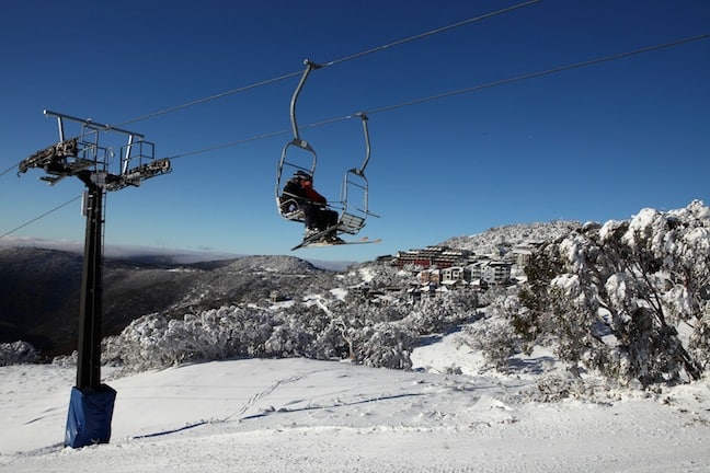
Hotham, Opening Weekend Image::Courtesy of Mt Hotham
The weekend was testing time for both Perisher and Thredbo who launched their new RFID (Radio Frequency Identification) lift validation systems. These systems seemed to work really well for both resorts, they should enable faster movement through the gates and consequently shorter lift lines! The other cool thing about this system is the ability for riders to keep track of their stats throughout the season. Perisher enables this through their “MyRide Dashboard” found online at www.perisher.com.au/myridedashboard, this online tool lets you keep track of where you rode, what parts of the hill and how many vertical metres you covered. This all seems pretty cool and I know that I would love to see other resorts follow suit! The added bonus is that it will be a pretty cool way to compete with your mates about who really did shred the hardest!
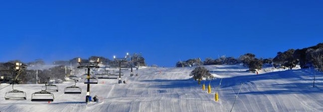
Perfection in Perisher Image::Courtesy of Perisher
Weather this Week…
The long weekend saw some fairly mild weather with light snowfalls, cloudy conditions and occasional sunny breaks. This was a result of the high-pressure system that has been dominant over our region for last 3-5 days. The ridge has resulted in a southeasterly airflow that has been continuing over the period. This fetch unfortunately resulted in a few showers/drizzle over Monday and Tuesday, this meant that the resorts lost a little of the early season base and higher traffic areas are beginning to thin.
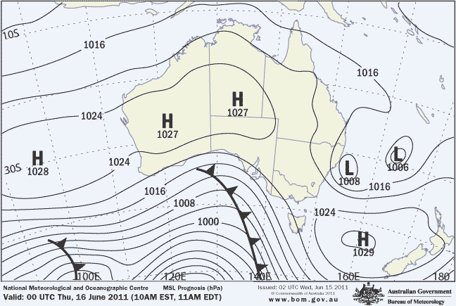
BOM Short Term Forecast Chart Image::Courtesy of BOM
The East Coast Low that is currently positioned off the northern NSW Coast is wreaking havoc up north causing widespread damaging floods and road closures. As “The Grasshopper” mentioned in his synoptic outlook on Monday 13 June, this rain band does not look like it will move far enough south to bring damaging rain to the mountains. So far it is behaving as forecast and will move slightly south along the coast before tracking east and into the Tasman.
As you can see on the Bureau’s short term forecast above there is a cold front approaching the south east of Australia from the Bight. At this point it is looking like this front may be pushed south just missing the alps. However small snowfalls are possible especially in the southernmost resorts.
Next Snowfalls?
Our best options for the next ‘major’ snowfalls are looking like next week on Monday and Tuesday 20/21 June. Our forecast models are tipping 20-30cms of snow over the two days to around mid- mountain at most resorts. We are still about 5 days out on this one at time of writing so the next few days will hold the key to understanding exactly what is likely, at this stage most models agree so it should be interesting at the very least!
Perisher conditions are great with Perisher continuing to have lifts open on front valley and other areas will open as conditions allow, the possibility of snow flurries across the weekend with 10-15cms possible Monday and into Tuesday.
Thredbo an early season cover is in great shape, Friday Flat, Merrits area and High Noon will remain open, snowmaking will continue when temperatures drop overnight. Some grass is exposed at lower elevations but the grooming team will do their best to keep the open runs covered. Snow flurries up high over the next few days then 5cms of snow late on Sunday, 10-15cms likely on Monday, 20-30 cms likely on Tuesday
Selwyn Snowfields at this point resort operations are on hold at Selwyn, flurries and the possibility of 3-5cms of snow is likely up till Friday, the weekend looks like a mixture between snow and rain with the possibility of another 3-5cms.
Mt Buller temperatures are looking mild with sunny conditions expected for Buller over the next few days, our models are predicting 3-5cms of snow over the weekend with the possibility of 10-15cms over Monday and Tuesday.
Falls Creek mostly partly cloudy until the weekend for Falls, the models are saying 20-30cms of snow Sunday through to Tuesday!
Mt. Hotham Partly cloudy with sunny breaks over the next few days, some snow flurries from Friday, our forecast models are saying that Hotham could receive between 40 and 60cms of snow from Sunday through to Tuesday!
Charlotte Pass are tipped to receive about 20cms of snow by Tuesday night, this is excellent news for the resort ahead of their planned opening on Friday 24 June
The Puyehue Volcanic Eruption – Possible Cooling effect?
One issue that has been discussed among the weather community over the last few days is the effect that the eruption of volcanic ash in the upper atmosphere could have on the climate in Australia. The way this works is basically that particles of sulphur dioxide are emitted very high into the upper atmosphere where they can act to reflect the energy of the sun back into space, this process can have a cooling effect on the climate that is termed “dimming”. In the past there has been a time lag associated with this process meaning that the effects may not be seen for a few months, however this eruption is on a latitude that is well positioned to impact Australia/New Zealand. If the eruption does have an effect it is likely that we could end up with slightly colder temperatures and more snow! Time will tell with this one, there are many factors at play but it is definitely something to keep an eye on!
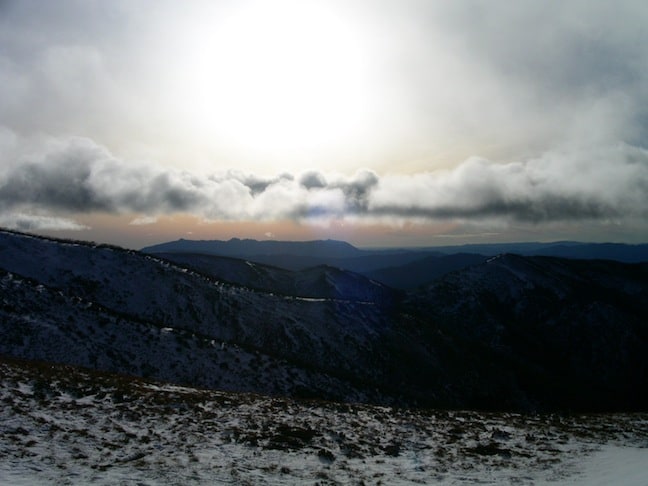
Volcanic ash moving over Hotham Image::Courtesy of Mt. Hotham
What is happening at the resorts?
A fairly quiet week is ahead in terms of events and happenings at the resorts as most wait in eager anticipation of the next natural snowfalls. Snowmaking will continue where possible as all resorts try to open more terrain and lifts as conditions allow. If you are looking for a cheap trip to the mountains there is plenty of great deals available on lift tickets and accommodation so it is a great time to take advantage of early season conditions.
Mt Buller is offering half price lift tickets, $52 for adults and $28 for children
Thredbo is holding the first round of their Thredbo Freeride Series on Saturday 18 June where some of Australia’s top Jibbers will throwdown in the Rails event. Visit www.thredbo.com.au/freeride/ for details.
Perisher has decided to extend their opening weekend special on lift tickets, only $80 for adults and $44 for children
Perisher forecasts,
snow reports and
live snow cams.
Falls Creek forecasts,
snow reports and
live snow cams.
Mount Buller forecasts,
snow reports and
live snow cams.
Charlotte Pass forecasts,
snow reports and
live snow cams.
Hotham forecasts,
snow reports and
live snow cams.
Thredbo forecasts,
snow reports and
live snow cams.
Mount Baw Baw forecasts,
snow reports and
live snow cams.


