New Zealand Forecast Monday August 17th – Unsettled Northerlies On The Way, But Snow Sunday and Next Monday
Mountainwatch | The Grasshopper
Valid Monday 17thAugust – Thursday 20thAugust
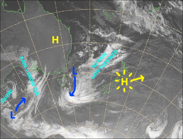
The run of clear winter days is about to come to an end as we bid bon voyage to the happy high-pressure system. The next few days will see an unsettled northerly flow descend upon the Country, bringing mostly scattered rain and strong winds.
The northerly flow is attached to a massive beast of a low-pressure system that forms south of the Tasman Sea. This gnarly looking thing will churn away for several days, and it won’t be until the weekend, when its cold western periphery hits us, that we’ll get any decent powder out of it.
Monday 17th
Another splendid clear, calm day.
Tuesday 18th
Cloud increasing as N-NW winds strengthen. Scattered rain developing in the evening, falling as snow about the tops except for at Mt Hutt.
Wednesday 19th
Scattered rain clearing during the morning, although the odd shower still possible for those resorts closest to the Main Divide. Strong NW winds, gale in Canterbury, will start abating.
Thursday 20th
Patches of blue sky, but showers possible for resorts closest to the Main Divide. Scattered rain developing afternoon or evening. Northerly winds, tending to a lighter northeast.
Extended Outlook
As I alluded to above, cold southerlies will hit the South Island and dump snow this Sunday and next Monday. Models vary, but at this stage 15-30cm looks likely for most resorts, whereas Mt Hutt could see up to 50cm.
An unsettled westerly flow over the South Island with two or three weak cold fronts should bring light snowfalls later next week into the following week. Then, a bigger system is on the cards around the turn of the month, so pencil that into your diaries folks.
That’s all from me today, guys.


