New Zealand Weekend Forecast, Friday August 16th – Strong Tasman Storm Hits this Weekend with Heavy Snow for Northern Canterbury

Mountainwatch | The Grasshopper
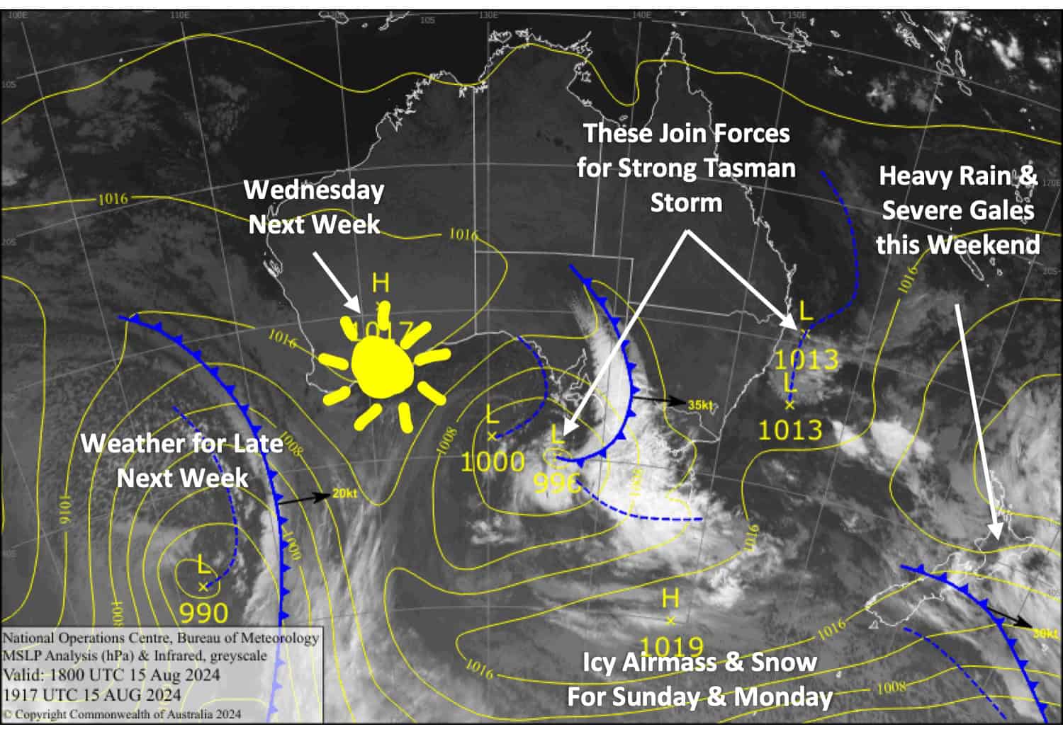
This weekend, a strong low from the north Tasman Sea will pass over the middle of the New Zealand, bringing heavy rain and severe gales to the North Island, where conditions will be atrocious on Mt Ruapehu.
However, icy cold southerlies and snow sneak up the South Island on Sunday. The snow will be heavy over the upper parts of the South Island, but due to uncertainty and model inconsistencies, it’s tricky to pick which resorts will cop it. Canterbury resorts from Mt Hutt northwards could see anywhere from 15-25cm up to around 60cm, with those resorts furthest north in the region standing the best chance for the deepest totals.
On Monday a strong surge of icy southwesterlies will bring more snow showers across the country, including Mt Ruapehu where 5-10cm could accumulate. This will also add to the Southern Lakes tally, which will also total around 5-10cm for both Sunday and Monday.
Friday August 16th
Plenty of sunshine amongst partly cloudy skies for South Island resorts, although it’ll be a bit more closed in for the Southern Lakes where there could also be a light snow flurry or two. W-NW winds will be quite brisk in exposed areas, especially in Canterbury.
A damp day for Mt Ruapehu as drizzle turns to rain in the morning, but it’ll fall as snow mostly above 1800m. Westerly winds.
Saturday August 17th
Cloud will continue loitering over the Southern Lakes throughout the day. Canterbury will be fine with high clouds, but rain will spread over the region in the evening about as far south as Mt Hutt. NW winds will be brisk in exposed areas again, especially in Canterbury.
If resorts open and you’re super keen, you might be able to squeeze in a morning session on Mt Ruapehu. But conditions will deteriorate significantly in the afternoon, with rain becoming heavy while northerly winds rise to severe gale, so don’t get caught out!
Sunday August 18th
In Canterbury, rain turns to snow in the morning as cold southerlies develop. Both wind and snow will start lightly but gradually build, with heavy snowfall likely in the upper half of the region. Snow will gradually lower to around 500m before easing at night.
The Southern Lakes will also see snow showers to low levels and icy southerly winds.
Mt Ruapehu will be a no goer with severe gale northwesterlies and heavy rain. It’ll turn to snow up high late in the day.
Monday August 19th
Strong, icy cold W-SW winds sweep over the country during the morning, reaching gale to severe gale in exposed areas and likely hampering lift operations.
Snow showers will continue over the Southern Lakes, and will spread northwards up Canterbury during the latter half of the day after a clear morning there. Rain on Mt Ruapehu will also turn to snow showers early morning.
Extended Forecast
The strong, cold SW flow will start to ease over the country on Tuesday before a ridge brings clear, calm skies on Wednesday.
The weather looks to become unsettled again through the back half of next week, with rain and strong NW winds leading up to a cold change with snow next weekend.
That’s all from me today, folks. The next forecast is Monday. See you then, and have a great Weekend.
Grasshopper


