The Grasshopper’s 2026-2027 North American Season Outlook – El Niño Presents a Mixed Bag for North America
Mountainwatch | The Grasshopper
Halfway through October, and the snow has already started falling at a few resorts across North America. It’s almost time for the North American season to begin, which means it’s also time for the Grasshopper’s seasonal outlook series to ramp up again. So, strap in as we take a first look at what to expect for the upcoming winter.
There has been some early excitement around Utah and Colorado with the first decent accumulations fall over the past few days, with a little more snow on the way. It’s a much-welcomed start to the winter ahead and, hopefully, a sign of bigger things to come…?
Catching Up
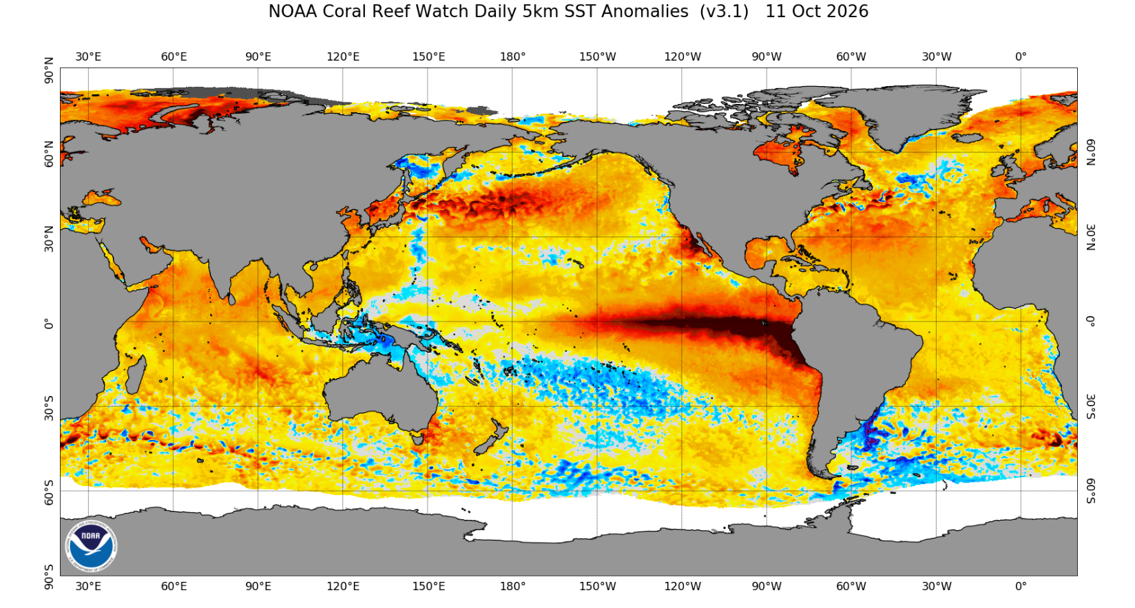
In case you haven’t been paying attention to the climate this year, we’ve been experiencing a record-breaking El Niño event, which was declared earlier than ever before during the Northern Hemisphere summer. Our mission now is to try to decipher what exactly that means for the upcoming North American season.
Below is a current sea surface temperature (SST) anomaly image showing just how pronounced this El Niño really is. We can see warm anomalies that are almost off the scale throughout the eastern equatorial Pacific.
When Will It Peak?
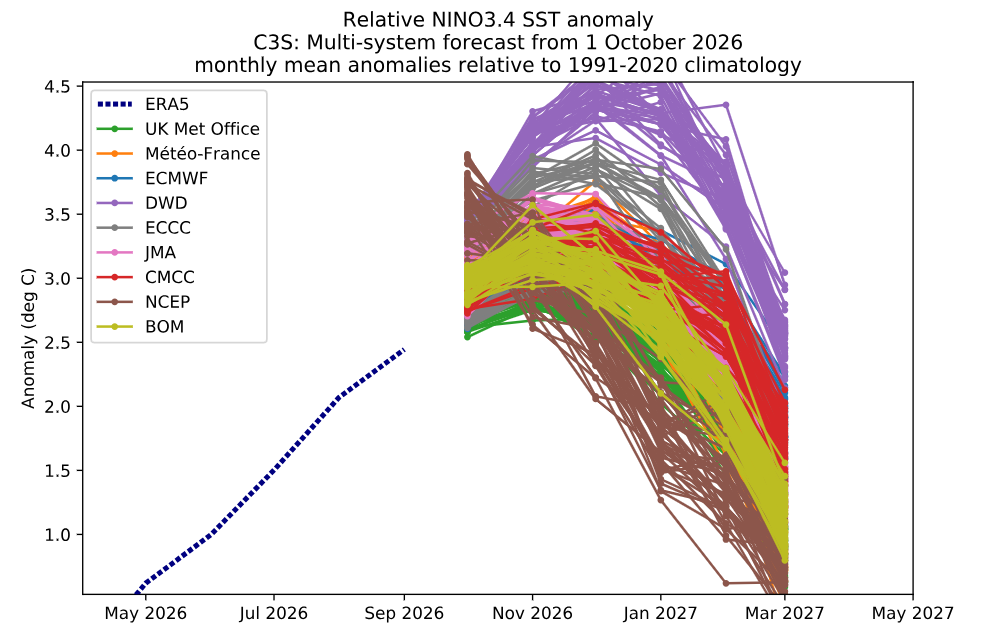
Currently, we’re still under an El Niño advisory, with the official wording from NOAA indicating a greater than 90% chance of a very strong event in the Northern Hemisphere during autumn and winter. This comes as no surprise.
Below is a plot showing ensemble forecasts from several major meteorological agencies for the Niño 3.4 anomaly. ENSO events usually peak during the winter (December–February) period. Most models indicate an early-winter peak before the event begins to ease through the start of next year.
Because this year’s event is so strong, any easing may not necessarily translate into an immediate change in conditions. The effects may already be set in motion, and although the event may be weakening in the grand scheme of things, conditions will still be well above the relevant thresholds.
ENSO and North America
Before we get into some of the seasonal products showing temperature and precipitation forecasts, let’s investigate what we might expect for the upcoming season with a quick revision of atmospheric dynamics.
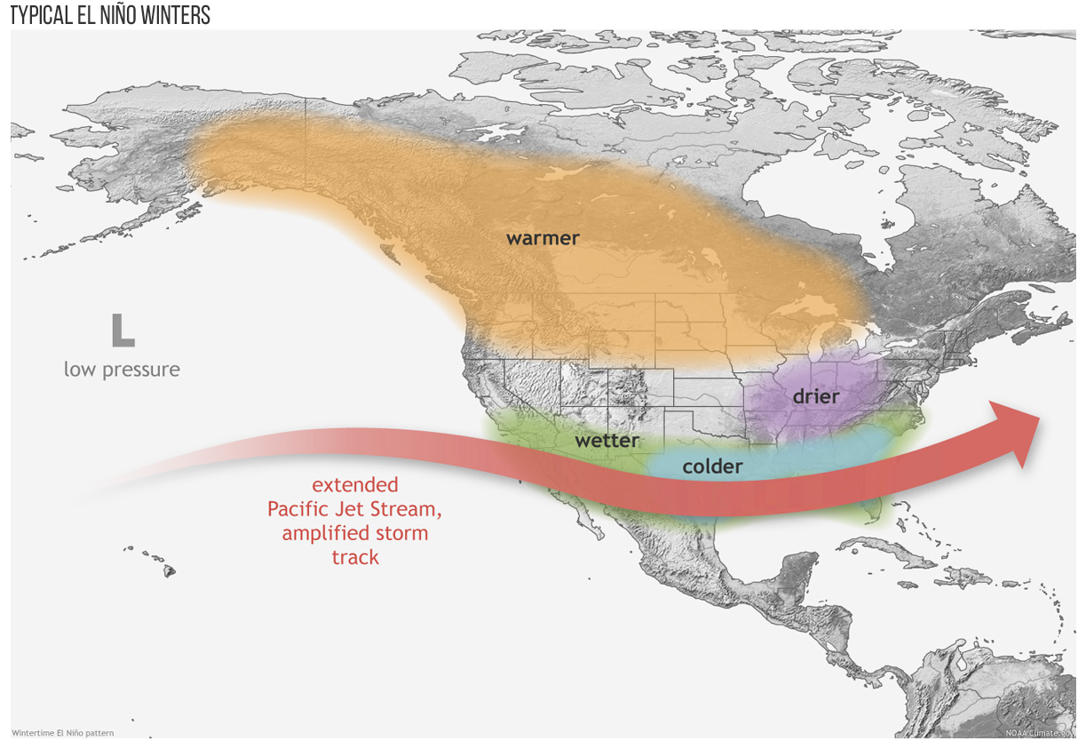
The impact of ENSO is felt during the North American winter through its influence on the jet streams. Jet streams help steer storms from the Pacific onto the North American continent. During an El Niño year, we typically see a southward shift in the storm track, driven by a southward shift in the subtropical jet stream.
In theory, this leads to increased precipitation in areas traditionally south of the usual jet stream position, such as New Mexico and the southern Rockies, and reduced precipitation in areas further north, such as the Pacific Northwest (PNW) and western Canada. During a La Niña event, the opposite tends to occur, with a northward shift that favours areas such as the PNW and Canada.
One way this shift in the storm track is communicated is through ENSO’s influence on the Aleutian Low, a semi-permanent area of low pressure around the Aleutian Islands. During an El Niño year, the Aleutian Low typically strengthens, helping push the jet streams further south. NOAA’s diagram below illustrates this pattern.
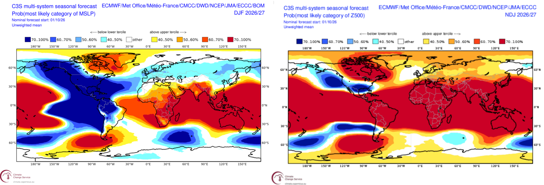
Keeping the above in mind, below are two forecasts for pressure over the upcoming winter. The image on the left shows mean sea-level pressure (MSLP), while the one on the right shows pressure at 500 hPa, higher up in the atmosphere. We can see broadly lower-than-average pressure across the Pacific and to the west of the continent, consistent with the pattern shown in the diagram above.
Seasonal Products
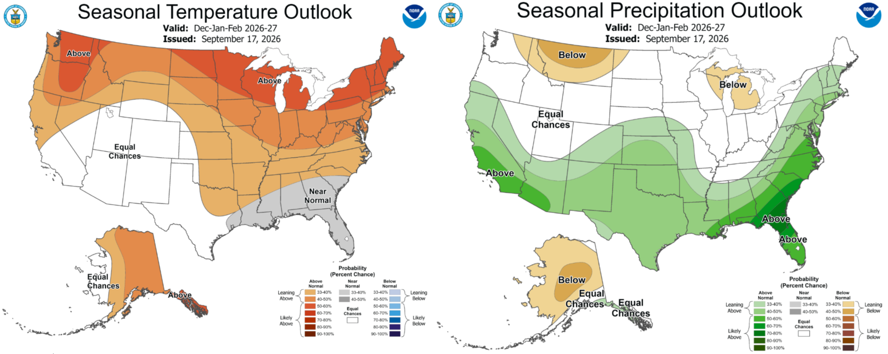
To better visualise the above, let’s focus first on the USA. Below are NOAA’s seasonal forecasts for the winter period. These forecasts may change slightly over the coming months, but for now, they suggest a reduction in precipitation in areas around the Northwest and increases further south. This is accompanied by warmer-than-average temperatures further north, with the outlook becoming more neutral as we move south.
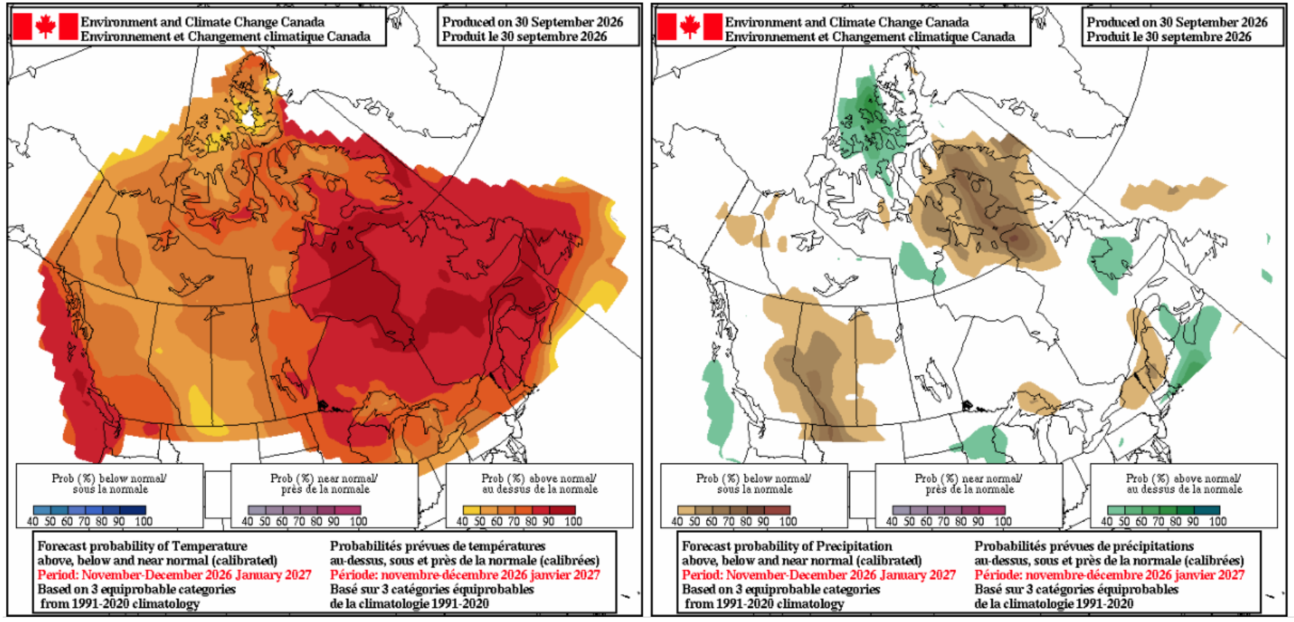
Moving north of the border, we have a similar product from Environment Canada. These forecasts cover the period from November to the end of January. In line with our expectations, they indicate an increased chance of below-average precipitation across the Canadian Rockies. For temperatures, the most likely scenario is average to above-average conditions across most of the country.
Wrap It Up
Overall, an El Niño year presents a mixed bag for North America and traditionally does not favour many of the regions synonymous with North American skiing and snowboarding. However, this is far from certain, with many areas falling into a middle ground where conditions can be influenced in either direction.
Areas such as the PNW and Canadian Rockies are arguably the least favourably positioned, while other regions, such as the Sierra Nevada, Utah and Colorado, sit in more of a grey area.
As the season progresses, we’ll revisit these forecasts monthly and investigate further where might be best placed for skiing and snowboarding during the coming winter. Also, my detailed weekly North American forecasts will start in mid-December