2019-2020 North American Snow Season Outlook – December Update
Snowy In The South and Slow In The North, But The Tables May Turn
Mountainwatch | The Grasshopper
All signs continue to favour the northern half of North America for the next three months, contrary to the run of things at the moment.
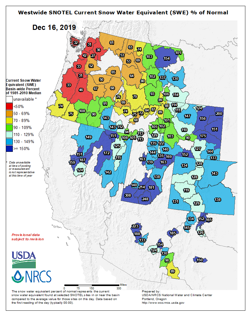
Snowfalls in the Sierras and most of the American Rockies (excluding Idaho) are running well above average, while the Cascades and Coast Mountains are well below average. The Canadian Rockies are mostly average or a little below.
The recent month of weather has undoubtedly favoured the southern half of North America. But this week, the snow pendulum has swung north, and snowfalls are already underway in what should equate to 35-75cm+ being added to those areas screaming out for snow. It may not be enough to bring them up to average, but it should open up more terrain and provide some good powder days.
From this Sunday through to the end of December however, short-term models indicate the pendulum will swing back south. Those mountains already sitting well above average are likely to cop another couple of decent snowstorms. When does lucky turn into greedy?
Pandemonium and a weak Aleutian Low
Looking further ahead, we’re having to rely more heavily on climate models and their reliance on recent trends, because our main driver of climate variation – the El Nino Southern Oscillation – is firmly locked in neutral. As if to make matters worse, these models show a lack of confidence. It’s a forecaster’s worst nightmare – chaos and disorder!
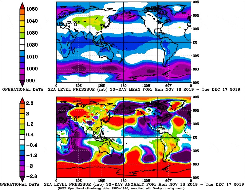
As we’d expect, climate models haven’t changed much since the previous outlook. They are consistent across the board in blotching high-pressure anomalies over the north Pacific and low-pressure anomalies over the eastern half of Canada for the next three months.
The high-pressure anomalies in the North Pacific indicate a weak Aleutian Low – an area of persistent and intense storm activity during winter. The diagram below sums up nicely what happens when we have a weak Aleutain Low.
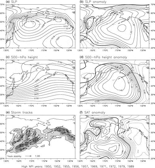
Notably, this tends to change the storm track so that they more frequently hit the Coastlines of British Columbia and Washington from the west and northwest, as opposed to hitting the Alaskan Coast from the south or southwest. This is likely to bring increased snowfall not only to the Coast Mountains and Cascades, but further inland to the Rockies possibly as far south as Wyoming. When the snow pendulum swings north like this, it usually comes at the expense of snowfalls farther south.
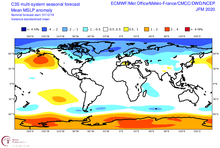
Forecasts from climate models and NOAA support this idea, and give us a slight chance of above average precipitation over Canada, Idaho, Montana and Wyoming. This precipitation pattern, however, may be influenced by increasing global temperatures where the air can hold more moisture. Some Alaskan Mountains, for example, have seen snowfall more than double since the mid-1800s.
Temperature outlooks have actually chilled off a little in these same areas since last month, and they are now not more likely to be warm, which says a lot in a cooking planet where all surrounding areas are likely to be. Normally we would expect these areas to be cooler than average when the Aleutian Low is weak, but “average” may now be the new “below-average” these days.
Same, same, but different
For this outlook, I’m sticking to my guns from what I said a month ago: all odds favour the north and not the south. It’s a risky call since the last month has shown the complete opposite. Yet that was only one month out of three. Phew, I’m safe!
Here, we’re now talking about snowfalls for the next three months and conveniently disregarding what has happened so far – reset and push play.
We can expect average-or-above snowfalls over Canada, Idaho, Montana and Wyoming. The Sierras are likely to receive average-or-below amounts, while the Cascades and remainder of the Rockies sit on the average fence where they could easily fall either way. As I alluded to before, the heavy use of “average” is not only because that’s a real option, but also due to the level of uncertainty.
That’s all from me folks. I’ll update this outlook in another month or so. Until then, have a merry Christmas and a happy New Year, and be sure to check out my weekly forecasts for Japan and North America.
If you’ve got a different theory on what’s going to happen this winter, or just want to provide feedback, then please hit me up on the discussion below. Or you can follow me on Facebook.


